
Carries 6 lanes of I‑5 Construction started 1915 Total length 1,078 m Height 70 m | ID number 01377, 07333 Opened 1915 Clearance below 54 m | |
 | ||
Similar Glenn L Jackson Memorial, Salmon Creek Regional, Waterfront Renaissance Trail Van, Columbia River Crossing, Marquam Bridge | ||
I 5 bridge columbia river interstate bridge to oregon
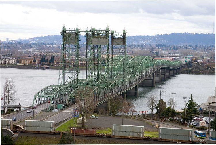
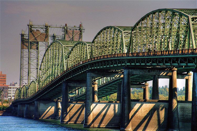
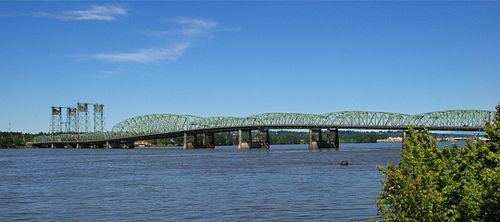
The Interstate Bridge (also Columbia River Interstate Bridge, I-5 Bridge, Portland-Vancouver Interstate Bridge, Vancouver-Portland Bridge) is a pair of nearly identical steel vertical-lift, "Parker type" through-truss bridges that carry Interstate 5 traffic over the Columbia River between Vancouver, Washington and Portland, Oregon in the United States.
Contents
- I 5 bridge columbia river interstate bridge to oregon
- I 5 bridge columbia river interstate bridge to washington
- First bridge
- Upgrades
- Replacement
- References
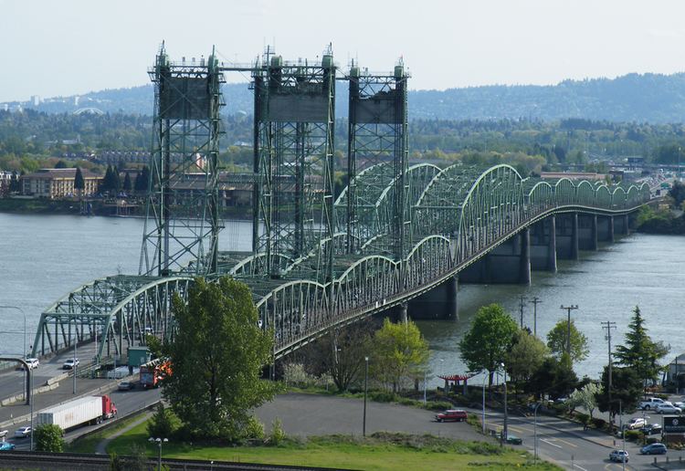
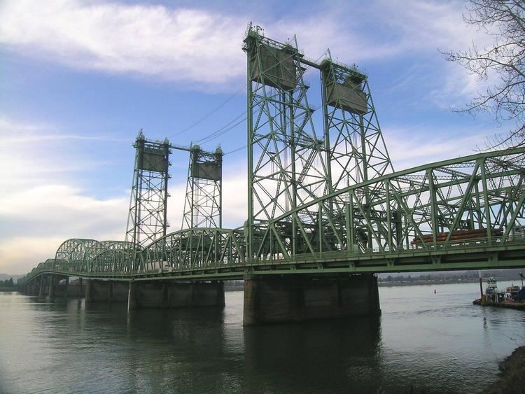
The bridge opened to traffic in 1917 as a single bridge carrying two-way traffic. A second, twin bridge opened in 1958 with each bridge carrying one-way traffic. The original 1917 structure is the northbound bridge. As of 2006, the bridge pair handles around 130,000 vehicles daily. The green structure, which is over 3,500 feet (1,067 m) long, carries traffic over three northbound lanes and three southbound lanes. It was added to the National Register of Historic Places in 1982, as the "Portland–Vancouver Highway Bridge".
Since 2005, proposals for replacing the bridge have been produced and debated. The bridge is considered responsible for traffic congestion of road vehicles and river traffic. Plans for a replacement bridge, known as the Columbia River Crossing (CRC) project, estimated to cost at least $3.4 billion, had come together by 2012 after many delays, but were very controversial, with both strong support and strong opposition. In late June 2013, the CRC project was canceled, after the Washington state legislature declined to authorize funding for the project.
The Interstate Bridge's name is a simple descriptive one based on its location, as a bridge connecting two states. In 1917, the new bridge gave its name to a Portland arterial street. Shortly before the bridge opened, a pair of streets through North Portland that were planned to be treated as the main route to and from the bridge, Maryland Avenue and Patton Avenue, were renamed Interstate Avenue.
I 5 bridge columbia river interstate bridge to washington
First bridge
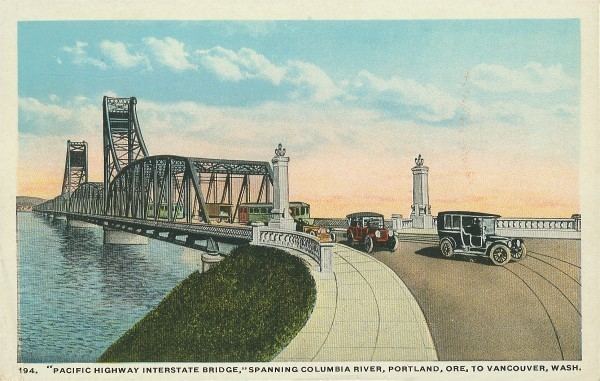
The bridge was built to replace an overcrowded ferry system operated by Pacific Railway, Light & Power Co. Construction on the bridge began in March 1915, following the sale of bonds. The first bridge was opened on February 14, 1917 at a cost of $1.75 million (equivalent to $33 million in 2016), which was shared between Clark County and Multnomah County. Clark County paid $500,000 and Multnomah County $1,250,000—probably proportional to population.
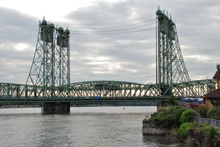
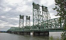
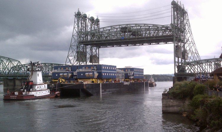
The first bridge has a total of 13 steel spans, with three measuring 275 feet (84 m) in length and the remaining ten spans 265 ft (81 m) each. Piers sit atop pile caps on wooden pilings approximately 70 feet deep. One of the 275-foot (84 m) spans is the lift span for allowing river traffic under the bridge. The lift span is capable of moving 136 ft (41 m) vertically, and provides 176 ft (53.6 m) of clearance below when fully raised. The towers are 190 ft (57.9 m) tall, above the roadway.
The original paved roadway was 38 ft (11.6 m) wide and had a 5 ft (1.52 m) wide sidewalk. It was the first automobile bridge across the river between Washington and Oregon, and the second to span the river at all, after the Wenatchee Bridge of 1908. It was originally a toll bridge costing 5¢ per vehicle or per horse and rider, equivalent to $0.93 in 2016. In 1928 the states of Washington and Oregon jointly purchased the bridge from the counties and discontinued tolling the following year.
Electric streetcars operated across the bridge from opening day in 1917 until 1940. The bridge's deck carried dual gauge track, to accommodate both Vancouver's standard gauge cars and Portland's 3 ft 6 in (1,067 mm) gauge cars. Before the bridge, Portland had had a Vancouver streetcar line since 1893, but it ran to Hayden Island, where passengers transferred to a ferry owned by the street railway company to continue across the river to Vancouver. Streetcar service across the Interstate Bridge ended on September 3, 1940.
The bridge became part of then-new Interstate 5 in 1957.
Upgrades
In 1958, a $14.5 million ($120.4 million in 2016 dollars) upgrade created a southbound span and doubled the capacity of the bridge. The new bridge was built with a "humpback" that provides 72 ft (21.9 m) of vertical clearance and minimizes bridge openings. At the time the new bridge was opened, the old one was temporarily closed for rebuilding to give it a matching humpback section. When both bridges were first open concurrently, in 1960, each bridge became one-way, and tolls were reinstated at $0.20 for cars, $0.40 for light trucks, and $0.60 for heavy trucks and buses, until removed in 1966 after the construction expenses were paid off. A $3 million ($5.5 million in 2016 dollars) upgrade to the lift cables, expansion joints, and a deck repaving was completed in 1990. The diesel generator used to power the lift was replaced in 1995 at a cost of $150,000. In 1999, the bridge was repainted at a cost of $17 million. A $10.8 million electrical upgrade was completed in mid-May 2005.
The bridge is 3,538 feet (1,078 m) long with a main span of 531 feet (162 m). The vertical lift provides 176 feet (53.6 m) of river clearance when fully opened. Openings last about ten minutes and occur between 10 and 20 times per month.
Outside peak commuting times (6:30 a.m. to 9 a.m. and from 2:30 p.m. to 6 p.m), marine traffic is granted right of way at the bridge by federal law (33 CFR 117.869).
In 2006 the six total lanes of the bridges carried 130,000 vehicles daily. Full traffic capacity occurs four hours every day.
Replacement
The bridge is frequently a bottleneck which impacts both traffic on the freeway, as well as on the river. The Oregon and Washington transportation departments are jointly studying how to replace the bridge. Both spans have been rated as "functionally obsolete," with sufficiency ratings of 18.3% and 49.4% for the original and second spans, respectively. Initially, the estimated cost for a replacement bridge was around $2 billion, but that number has climbed steadily to around $3.4 billion. An independent study in 2010 estimated the full cost to be closer to $10 billion.
Design of a replacement (especially a fixed-span bridge) is complicated by the existence of a railroad drawbridge crossing the Columbia a short distance downriver (on the Burlington Northern Railroad Bridge 9.6), which constrains the location of the shipping channel; and by approach paths to Portland International Airport in Portland and to Pearson Field in Vancouver, which limit the height of any new structure. Some have proposed replacing the bridge in a different location. There were originally 12 transportation plans that were being studied to improve and expand the Interstate 5 crossing of the Columbia River. In late 2006, four of these plans were selected for a final proposal, along with a fifth no-build option. The Columbia River Crossing project's six local partner agencies selected a replacement I-5 bridge and light rail extension to Clark College as the project's Locally Preferred Alternative (LPA) in 2008.
There is also a longstanding debate as to whether or not a new bridge would include a MAX Light Rail line, express buses, or bus rapid transit. During his 2007 "State of the City" address, Vancouver mayor Royce Pollard stated
In December 2007, Oregon governor Ted Kulongoski advocated for a new bridge, publicly endorsing the Oregon Business Plan's proposal.
In 2008, as fuel prices increased and project cost estimates soared, many in the area began questioning whether the project is worth the costs. In addition, many on the Portland side of the river fear that a 12-lane highway bridge to Vancouver, which many also believe has virtually no land use restrictions, will encourage suburban sprawl and development north of the river.
Further concerns over the 12-lane "Columbia River Crossing" (CRC) proposal include its failure to examine critical environmental impacts, such as damage to Clark County's drinking water supply, endangered fish habitat in the Columbia, and air pollution in North Portland.
In 2008, the Environmental Protection Agency found that the Draft Environmental Impact Statement for the CRC had failed to adequately cover these issues, as well as the potential induced demand for suburban sprawl. In a letter to CRC planners, the EPA wrote that "There was no indication (in the CRC environmental impact statement) of how these vulnerable populations might be impacted by air pollution, noise, diesel construction vehicles and increased traffic", referring to minority communities in North Portland.
In June 2013, the Washington Legislature voted against further funding of the CRC. On June 29, Oregon Governor Kitzhaber directed the CRC to shut down operations.