
Existed: 1991 – present Length 15.9 km | Constructed 1991 | |
 | ||
West end: | ||
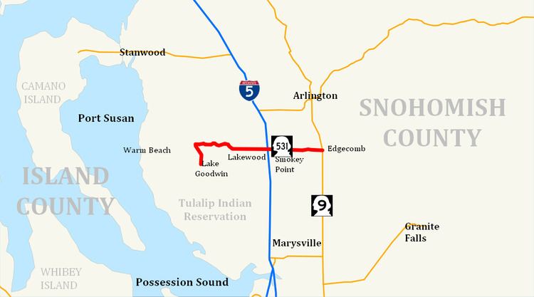
State Route 531 (SR 531) is a short Washington state highway in Snohomish County. It extends east 9.88 miles (15.90 km), from Wenberg County Park in the community of Lake Goodwin, to SR 9 in southeast Arlington. SR 531 intersects Interstate 5 (I-5), and passes the Arlington Airport. The route connects I-5 to SR 9, Smokey Point, and Wenberg County Park. The Washington State Legislature approved SR 531's current route in 1991. Since then, construction projects, arranged by the Washington State Department of Transportation (WSDOT), have turned this small road into an arterial street. Even though the Washington State Legislature and WSDOT approved SR 531 in 1991, they erected no signs until April 1, 1992, when the law creating the road took effect.
Contents
Map of State Rte 531, Meshoppen, PA 18630, USA
The road now used by SR 531 has existed as a separate route since at least 1911. A map dating from 1911 shows that 172nd Street, then known simply as Lakewood Road and Edgecomb Road, extended east from its current intersection with SR 9 to the banks of the South Fork Stillaguamish River.
Route description
State Route 531 runs about 9.88 miles (15.90 km), from Wenberg County Park to State Route 9 south of Arlington. The route links the communities of Lake Goodwin, North Lakewood (also known as Lakewood), Smokey Point, and Edgecomb. It also passes four schools in the Lakewood School District, as well as Weston High School in the Arlington School District. The road intersects four major arteries: Forty-Five Road, Interstate 5, Smokey Point Boulevard (formerly known as U.S. Route 99), and 67th Avenue, before ending at SR 9. WSDOT found that, based on average annual daily traffic (AADT) data, about 35,000 motorists utilize the road daily at the I-5 interchange.
Starting at Wenberg County Park, the route runs north along East Lake Goodwin Road until it intersects Lakewood Road. From there, SR 531 travels east along Lakewood Road around Lake Ki before reaching Forty-Five Road. Here, Lakewood Road becomes the main artery of North Lakewood and Smokey Point, 172nd Street. Continuing east, SR 531 intersects 11th Avenue.
After intersecting 11th Avenue, SR 531 becomes the northern boundary of the Lakewood High School campus. SR 531 continues east from 11th Avenue to 16th Drive, shortly after entering Marysville city limits. Soon thereafter, the road intersects 19th Drive, which connects the southeastern section of North Lakewood with SR 531. Continuing east across a double track, the highway intersects 27th Avenue, which connects the road with Lakewood Crossing, a shopping center in Lakewood. SR 531 then continues further east to the interchange with I-5.
After leaving the interchange with I-5, along with North Lakewood and Marysville city limits, SR 531 continues east to Smokey Point Boulevard (formerly U.S. Route 99) in Smokey Point. The road then maintains straight east, passing Weston High School and Arlington Municipal Airport before intersecting 67th Avenue. From 67th Avenue, SR 531 travels east to a suburban community of Edgecomb. The road curves northeast and then southeast while on a hill. SR 531 travels east past the Arlington Gun Range and Gleneagle, a large housing area, before ending at an intersection with SR 9.
History
The whole stretch highway from Wenberg County Park to current SR 9 has been known to exist earlier than 1911. 172nd Street NE, now SR 531, once extended from what is currently SR 9 to the banks of the South Fork Stillaguamish River. This part of the highway has been removed.
SR 531 became a state highway in 1991, but the highway designation did not take effect until April 1, 1992. In 2006, WSDOT announced it would complete three more projects over about five years to improve SR 531. The first, to improve the bridge and interchange between I-5 and SR 531, began immediately. The Tulalip, Stillaguamish, Samish and Kikiallus Tribes helped fund the construction of the project. On April 30, 2005, the old two-lane SR 531 bridge was demolished during the night. WSDOT redirected traffic on SR 531 to the completed north side of the new bridge, while the northbound lanes of Interstate 5 were closed to all traffic and rerouted on ramps from I-5 to SR 531. During construction, eastbound SR 531 left-turn lanes were closed; a detour on Smokey Point Boulevard and SR 530 provided direct drivers access to northbound I-5. The other half of the bridge was later demolished in May 2005. All of the temporary structures on the bridge were subsequently removed in December 2005. Partly finished in June 2006, WSDOT plans to complete the project after adding a loop ramp in 2011. In August 2007, WSDOT completed a project to add sidewalks along SR 531 to the adjacent schools of the Lakewood School District.
An upcoming project, adding a loop ramp onto the I-5 interchange, started in March 2009 and will end in 2011. WSDOT has awarded the contract for the project to Northwest Construction, Inc. Part of the project includes widening the main entry point to Lakewood Crossing, by adding turn pockets. Widening SR 531 between 43rd Avenue NE and 67th Avenue NE from its current two to five lanes near the Arlington Airport is another planned project. The project is currently in planning stages and WSDOT has set up a webpage for the project.
Major intersections
The entire highway is in Snohomish County.