
Length: 296.92 mi (477.85 km) | ||
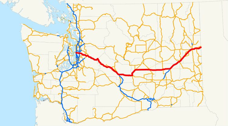 | ||
Interstate 90 (I-90), a transcontinental Interstate Highway from Seattle, Washington, to Boston, Massachusetts, crosses the state of Washington before crossing the Idaho state line between Spokane and Post Falls. It serves the cities of Seattle, Bellevue, Issaquah, Ellensburg, Moses Lake, Ritzville, and Spokane.
Contents
- Seattle to Snoqualmie Pass
- Seattle Bellevue Express Lanes
- Snoqualmie Pass to Ritzville
- Ritzville to Idaho
- History
- Reversible express lanes
- References
It is the only Interstate Highway to cross the state east to west, but there are two U.S. Routes that also do the same, U.S. Route 2 and U.S. Route 12, along with a few state highways. I-90 is also the only highway in Washington to connect the two largest cities in the state (Seattle and Spokane). The road is the third busiest in the state, behind I-5 at 240,000 and I-405 at 201,000. An estimated 148,000 motorists use the road daily.
I-90 incorporates two of the longest floating bridges in the world, the Lacey V. Murrow Memorial Bridge and the Homer M. Hadley Memorial Bridge, which cross Lake Washington from Seattle to Mercer Island, Washington. They are the second- and fifth-longest such bridges, respectively.
Seattle to Snoqualmie Pass
Interstate 90 starts at the intersection of SR 519 and 4th Ave S in Downtown Seattle. The recently rebuilt freeway joins the I-90 Express Lanes and goes east to an interchange with I-5. After leaving the interchange, the highway travels through the Central Area and into the Mount Baker Tunnel, a tunnel on the National Register of Historic Places that carries I-90 and its express lanes under the Mount Baker neighborhood. After emerging from the eastern portal of the tunnel, I-90 splits and the eastbound lanes go on the Lacey V. Murrow Memorial Bridge and the westbound lanes exit off the Homer M. Hadley Memorial Bridge, which is shared with the I-90 express lanes, both over Lake Washington.
After crossing Lake Washington into an area known as "the Eastside", I-90 enters Mercer Island and goes under the Mercer Island Lid at West Mercer Way and emerges at 76th Avenue SE before leaving Mercer Island to cross over Lake Washington again on the shorter East Channel Bridge into the city of Bellevue. The freeway continues east, passing an interchange with Bellevue Way, where the express lanes end, before a large stack interchange at I-405 near the Factoria Mall.
The freeway travels through the Eastgate area of Bellevue and passes Bellevue College, Lake Sammamish, and Lake Sammamish State Park before entering Issaquah and intersecting SR 900.
After passing by downtown Issaquah, the highway goes along the northern boundary of the Tiger Mountain State Forest and passes Preston, where the speed limit raises from 60 MPH to 70 MPH, before intersecting SR 18 in Upper Preston. From Upper Preston, I-90 passes Echo Lake and Snoqualmie before entering North Bend, where SR 202 begins after an interchange with the highway.
Seattle-Bellevue Express Lanes
Interstate 90 has a 7.45-mile (11.99 km) long reversible express lane that goes across Lake Washington from Seattle to Bellevue. The express lane starts at two different locations, one at the southern terminus of the Downtown Seattle Transit Tunnel and the other at a signalled intersection at 5th Avenue S., S. Dearborn Street, and Seattle Blvd. The lanes turn east and travel in a separated right-of-way before traveling towards the middle of I-90 east of the interchange with I-5. This section is bi-directional, containing two lanes separated by a barrier, and allows buses to use the lanes in both directions at all times. From there, the lanes travel through the Mount Baker Tunnel and onto the Homer M. Hadley Memorial Bridge, sharing the bridge with the westbound lanes. From there, the lanes travel through Mercer Island and ends at its terminus with the I-90 interchange with Bellevue Way, with ramps connecting to mainline I-90 and I-405.
Segments of the express lanes between the western terminus and I-90 ramps and Island Crest Way and the eastern terminus are reserved for HOV only. The westbound traffic uses the express lanes from 1 am to 12:30 pm (Monday–Friday) The eastbound traffic uses the express lanes from 2 pm to 12 midnight (Monday–Friday) and all day from Saturday to Sunday. The express lanes are closed every other Tuesday from 10 am to 1:30 pm.
Snoqualmie Pass to Ritzville
Around 42 miles east of Bellevue, at milepost 53, I-90 traverses the Cascade Mountains via Snoqualmie Pass, elevation 3,022 feet (921 m), the only interstate crossing and lowest east–west crossing in Washington State. I-90 then goes out towards the Columbia Plateau, passing through the cities of Cle Elum and Ellensburg, where it intersects with Interstate 82. It crosses the Columbia River on the Vantage Bridge. After passing into Grant County, North Frontage Road and South Frontage Road parallel I-90 through Grant County. The frontage roads intersect each exit off I-90 (Exits 143 to 174 and Exits 179 to 184). In Moses Lake at Exit 174, the frontage roads end. The freeway passes through Moses Lake. The frontage roads begin again at Exit 179 in Moses Lake and end at the Adams County line.
Ritzville to Idaho
At Ritzville, I-90 forms a concurrency with US 395 towards Spokane, where US 2 also forms a concurrency and both US 395 and US 2 branch off from I-90 at Downtown Spokane. I-90 continues to head east through the suburbs of Spokane and into Idaho.
History
As part of the state's first connected state highway system, the Washington State Legislature designated the Sunset Highway between Seattle and Idaho in 1913. Later in 1915, the Legislature also designated the North Central Highway between Ellensburg and Davenport. The State Highway Board selected two routes that would partially connect the main cities of Western Washington to Eastern Washington and Idaho. In 1923, by which time the entire road had been improved and a new connection had filled in a small gap, the Sunset Highway became State Road 2 (Primary State Highway 2 after 1937), but retained its name. The North Central Highway became State Road 7 (Primary State Highway 7 after 1937), but retained its name. Another highway, named Primary State Highway 18 between George and Ritzville. By that time, most of the route of Interstate 90 became US 10, which was established in 1926. Until 1940, the route headed south from Seattle to Renton, then east to Issaquah, in order to travel around Lake Washington.
Interstate 90 crosses Lake Washington between Seattle and Bellevue on a pair of floating bridges that are two of the world's longest floating bridges. The westbound lanes travel on the Homer M. Hadley Memorial Bridge, the fifth longest floating bridge, and the eastbound lanes travel on the Lacey V. Murrow Memorial Bridge, the second longest floating bridge. The Lacey V. Murrow Memorial Bridge, originally called the Lake Washington Floating Bridge, opened on July 2, 1940. The bridge sank during construction on November 25, 1990. It was later rebuilt and the new bridge opened later in 1993. The second bridge, the Homer M. Hadley Memorial Bridge, opened on June 4, 1989.
Later in 1956, President Dwight D. Eisenhower signed the Federal-Aid Highway Act of 1956 which started the construction of Interstate Highways. By 1969, US 10 was removed from the system entirely. During the construction of the freeway between Seattle and Bellevue, lawsuits were filed on May 28, 1970 and stopped construction of Interstate 90 until the early 1990s. Legally, the Washington section of I-90 is defined at Washington Revised Code § 47.17.140. In 1998, I-90 from Seattle to Thorp was designated the Mountains to Sound Greenway to protect its outstanding scenic and cultural resources.
Before 2003, Interstate 90 used to end at a signalled intersection with 4th Avenue S. However, increasing traffic from Downtown Seattle, Colman Dock, Safeco Field, and Qwest Field forced city, county, and state officials to look for improvements to the area. The first stage of the improvements, the SR 519 South Seattle Intermodal Access Project, included the construction of a new on-ramp to Interstate 90 via a new interchange with 4th Avenue S. and Edgar Martínez Drive S. (formerly S. Atlantic Street). Other projects are currently ongoing and have been completed in the recent years on I-90.
Reversible express lanes
The entire route is in King County.