
Existed: 1942 – present Constructed 1942 | Length 377 km | |
 | ||
Highway system British Columbia provincial highway system | ||
Pemberton bc duffey lake rd portage rd pemberton british columbia highway 99
Highway 99, also known as the Fraser Delta Thruway south of Vancouver, and the Sea to Sky Highway, the Squamish Highway, or Whistler Highway north of Vancouver, is the major north–south artery running through the Greater Vancouver area of British Columbia from the U.S. border, up Howe Sound through the Sea to Sky Country to Lillooet, and connecting to Highway 97 just north of Cache Creek. The number of this highway is derived from the old U.S. Route 99, with which the highway originally connected. The highway currently connects with Interstate 5 at the international border.
Contents
- Pemberton bc duffey lake rd portage rd pemberton british columbia highway 99
- Map of BC 99 British Columbia Canada
- South Surrey to Richmond
- Vancouver
- Trans Canada HighwayUpper Levels Highway
- Sea to Sky Highway and Duffey Lake Road
- Major intersections
- References
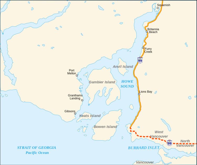
Map of BC-99, British Columbia, Canada
This highway received the "99" designation in 1942 after completion of the King George VI Highway (1940) to the U.S. border, and it originally shared an alignment with Highway 1 from Surrey to Vancouver via the Pattullo Bridge and Kingsway. The current freeway alignment of Highway 99 between 8th Avenue in South Surrey and the North Arm of the Fraser River opened in 1962 as Hwy. 99 and was called the Deas (Island) Throughway. Between 1964 and 1973, the freeway alignment of Highway 99 was designated Highway 499. The Oak Street Bridge was built in 1957 to cross the North Arm Fraser River, and the Deas Island Tunnel was built 1957–59 (renamed the George Massey Tunnel in 1967) to cross the Fraser River. Tolls were collected at the crossings until April 1 1963.
In 1957, the northern end of Highway 99 was moved from downtown Vancouver, across the Lions Gate Bridge and west to the village of Horseshoe Bay, following Marine Drive through West Vancouver. Highway 99 was re-aligned via Taylor Way, just east of the Park Royal Shopping Centre, to the Upper Levels Highway and extended to Britannia Beach one year later, extending to Squamish in 1959, and to Pemberton in 1966. Finally, in 1992, the just-paved Duffey Lake Road between Pemberton and Lillooet was made part of Highway 99, and the section of Highway 12 between Lillooet and Highway 97 was re-numbered 99. The portion of the highway between Lillooet and Pavilion was part of the route of the Old Cariboo Road.
The total length of Highway 99 from the U.S. border to the Highway 97 junction is 409 kilometres (254 mi). In 2006 the UK's The Guardian newspaper listed the Sea to Sky as the fifth best road trip worldwide.
South Surrey to Richmond
In the south, Highway 99 begins at the British Columbia – Washington State border crossing at Douglas, on the Canadian side of Peace Arch Park, as a continuation of Interstate 5. The highway begins with a four-lane freeway configuration. Highway 99 travels through Surrey 12 kilometres (7.5 mi) due northwest from the border, through four interchanges, and then turns west for 4 kilometres (2.5 mi) before reaching the junction with Highway 91, marking the highway's entry into the Corporation of Delta. Four km (2½ mi) west, Highway 99 reaches its junction with Ladner Trunk Road (formerly Highway 10). Eight km (5 mi) north, Highway 99 reaches a junction with Highway 17A. Another 2 kilometres (1.2 mi) northwest, Highway 99 crosses into Richmond through the George Massey Tunnel, also known as the Deas Tunnel or Deas Island Tunnel. From Surrey to Vancouver, the speed limit is 100 kilometres per hour (62 mph).
Through Richmond, Highway 99 travels 7 kilometres (4.3 mi) north from the Steveston Highway interchange, at the north mouth of the tunnel, to a junction which connects to the Westminster Highway, Knight Street, and western end of Highway 91. Another 4 kilometres (2.5 mi) northwest, the southern freeway section of Highway 99 ends as the highway crosses the North Arm of the Fraser River, over the Oak Street Bridge, into Vancouver.
Vancouver
The 30-kilometre (19 mi) long route through Vancouver's city streets starts off going north on Oak Street to the intersection with West 70th Avenue. Highway 99 then goes west on West 70th Avenue, and then north along Granville Street for 7 kilometres (4.3 mi), 41st Avenue is used as an alternate signed connection between Granville and Oak Streets. It crosses over False Creek (via the Granville Street Bridge) into the downtown core. Highway 99 north goes through the downtown area by way of Seymour Street (southbound it uses Howe Street) and Georgia Street, through Stanley Park, and over the Lions Gate Bridge into West Vancouver at Marine Drive.
Trans-Canada Highway/Upper Levels Highway
In West Vancouver, Highway 99 goes west on Marine Drive and north on Taylor Way, to Highway 1. Highway 99 shares the Upper Levels Highway with Highway 1 for 12 kilometres (7.5 mi) west, diverging from Highway 1 near the BC Ferries terminal at Horseshoe Bay.
Sea to Sky Highway and Duffey Lake Road
The "Sea to Sky Highway" is the name given to the section of Highway 99 from Horseshoe Bay to Pemberton. From Horseshoe Bay, the highway travels along the coast of Howe Sound for 12 kilometres (7.5 mi) to Lions Bay, north for another 21 kilometres (13 mi), crossing into the Squamish-Lillooet Regional District en route to Britannia Beach, and north for 11 kilometres (6.8 mi) to Squamish, at the head of Howe Sound. From Squamish, it continues north for another 58 kilometres (36 mi) to Whistler, and then to Pemberton 32 kilometres (20 mi) later, where the Sea-to-Sky Highway ends and Duffey Lake Road begins. After going for almost 100 winding kilometres in very steep mountains where sometimes the speed limit is 30 km/h, (99 km) (62 mi) northeast, Highway 99 reaches the junction with Highway 12 at Lillooet, and then goes northeast for another 75 kilometres (47 mi) to its northern terminus at its junction with Highway 97, just north of Cache Creek and just south of Clinton. The speed limit of the Sea-to-Sky Highway ranges from 80 kilometres per hour (50 mph) to 100 kilometres per hour (62 mph) with 60 kilometres per hour (37 mph) sections in Lions Bay, Britannia Beach and parts of Squamish.
The Sea to Sky Highway section of Highway 99 has a checkered history. Built on a steep cliff overlooking Howe Sound, it was a two-lane undivided highway with no outside barrier. Many motorists have lost their lives on it due to inclement weather, poor visibility, speeding, passing slower vehicles, or drunk driving.
As part of the 2010 Winter Olympics bid, the British Columbia provincial government authorized an upgrade of the highway to accommodate greater traffic loads, widening the highway and adding a concrete divider. Starting in 2002 a large section was upgraded between Squamish and Whistler that had already seen major improvements during the 1980s. The Sea to Sky is a freeway from the interchange with Highway 1 to the at-grade intersection with Lawrence Way. After that, there are sporadic interchanges and at-grade intersections. It is mostly a divided highway all the way to Lions Bay and through Squamish.
On-site protests delayed part of the construction. Protesters claimed that a tunnel under Eagleridge Bluffs was a safer and environmentally friendlier alternative. A court injunction and police were used to remove the protestors, one of whom, Harriet Nahanee, a respected Squamish elder, died soon after in the Surrey Pre-Trial Centre from health complications alleged to be related to her arrest and incarceration.
Major intersections
From south to north: