
Website Official website Literacy 83.3% | Major highways NH 16 Area 1,467 km² Average annual precipitation 1,461 | |
 | ||
Points of interest Belur Math, Acharya Jagadish Chandra, Vidyasagar Setu, Swami Vivekananda Temple, Ramakrishna Museum Colleges and Universities Indian Institute of Engineeri, Narasinha Dutt College, Bijoy Krishna Girls' Coll, Ramakrishna Mission Vivekana, Dinabandhu Institution | ||
Howrah district (Pron:ɦauːɽaː) (Bengali: হাওড়া জেলা) is a district of the West Bengal state in eastern India. It has thousands of years of rich heritage in the form of the great Bengali kingdom of Bhurshut. The district is named after its headquarters, the city of Howrah.
Contents
- Map of Howrah West Bengal
- Geography
- Administrative subdivisions
- Howrah Sadar subdivision
- Uluberia subdivision
- Assembly constituencies
- Impact of delimitation of constituencies
- Demographics
- References
Map of Howrah, West Bengal
Geography
The Howrah district lies between 22°48′ N and 22°12′ N latitudes and between 88°23′ E and 87°50′ E longitudes. The district is bounded by the Hooghly River and the North 24 Parganas and South 24 Parganas districts on the east, on the north by the Hooghly district (Arambagh and Shrirampur sub-divisions), and on the south by Midnapore East district (Tamluk sub-division). On the west Howrah district is bordered by the Ghatal sub-division of Midnapore West district, and partly by the Arambagh sub-division of Hooghly district to the north-west, and the Tamluk sub-division of Midnapore East district to the south-west.
Boundaries of the district are naturally determined by Rupnarayan River on west and south-west, and by Bhagirathi-Hooghly river on east and south-east side. On north side, the boundary is an artificial one except for Bally Canal on north-east and Damodar River on north-west.
Annual normal rainfall is 1461 millimetre per year. Annual maximum temperature varies between 32-39 °C, whereas minimum temperature varies between 8-10 °C.
Administrative subdivisions
Howrah district has two subdivisions: Howrah Sadar and Uluberia. Howrah Sadar consists of Bally municipality and Howrah municipal corporation and five community development blocks (CD blocks): Bally–Jagacha, Domjur, Panchla, Sankrail and Jagatballavpur. Uluberia subdivision consists of Uluberia Municipality and nine CD blocks: Uluberia–I, Uluberia–II, Amta–I, Amta–II, Udaynarayanpur, Bagnan–I, Bagnan–II, Shyampur–I and Shyampur–II.
Howrah district has 1 municipal corporation in Howrah, 2 municipalities in Bally and Uluberia. Rest of the area under this district is divided in 14 community development blocks. Each block consists of rural area divided into gram panchayats along with urban units like census towns. This district has 11 police stations, 157 gram panchayats, and 50 census towns. Khalisani in Uluberia - II block and Chak Srikrishna in Sankrail block were noted as urban outgrowths in census 2001.
Howrah Sadar subdivision
Uluberia subdivision
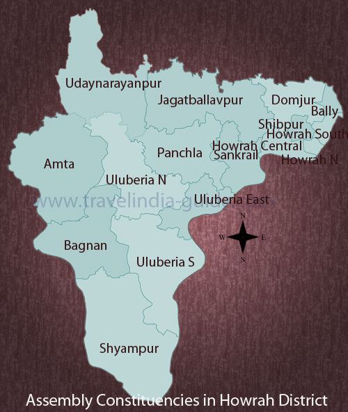
Assembly constituencies
The district is divided into 16 assembly constituencies:
- Bally (assembly constituency no. 161),
- Howrah North (assembly constituency no. 162),
- Howrah Central (assembly constituency no. 163),
- Howrah South (assembly constituency no. 164),
- Shibpur (assembly constituency no. 165),
- Domjur (assembly constituency no. 166),
- Jagatballavpur (assembly constituency no. 167),
- Panchla (assembly constituency no. 168),
- Sankrail (SC) (assembly constituency no. 169),
- Uluberia North (SC) (assembly constituency no. 170),
- Uluberia South (assembly constituency no. 171),
- Shyampur (assembly constituency no. 172),
- Bagnan (assembly constituency no. 173),
- Kalyanpur (assembly constituency no. 174),
- Amta (assembly constituency no. 175) and
- Udaynarayanpur (assembly constituency no. 176).
Sankrail and Uluberia North constituencies are reserved for Scheduled Castes (SC) candidates. Bally, Howrah North, Howrah Central, Howrah South, Shibpur, Domjur and Sankrail constituencies form the Howrah (Lok Sabha constituency). Uluberia North, Uluberia South, Shyampur, Bagnan, Kalyanpur, Amta and Udaynarayanpur constituencies form the Uluberia (Lok Sabha constituency). Along with five assembly constituencies from Hooghly district, Jagatballavpur and Panchla constituencies form the Serampore (Lok Sabha constituency).
Impact of delimitation of constituencies
As per order of the Delimitation Commission in respect of the delimitation of constituencies in the West Bengal, the district will be divided into 16 assembly constituencies:
- Bally (assembly constituency no. 169),
- Howrah Uttar (assembly constituency no. 170),
- Howrah Madhya (assembly constituency no. 171),
- Shibpur (assembly constituency no. 172),
- Howrah Dakshin (assembly constituency no. 173),
- Sankrail (SC) (assembly constituency no. 174),
- Panchla (assembly constituency no. 175),
- Uluberia Purba (assembly constituency no. 176),
- Uluberia Uttar (SC) (assembly constituency no. 177),
- Uluberia Dakshin (assembly constituency no. 178),
- Shyampur (assembly constituency no. 179),
- Bagnan (assembly constituency no. 180),
- Amta (assembly constituency no. 181),
- Udaynarayanpur (assembly constituency no. 182),
- Jagatballavpur (assembly constituency no. 183) and
- Domjur (assembly constituency no. 184).
Sankrail and Uluberia North constituencies will remain reserved for Scheduled Castes (SC) candidates. Bally, Howrah North, Howrah Central, Shibpur, Howrah South, Sankrail and Panchla constituencies will form the Howrah (Lok Sabha constituency). Uluberia East, Uluberia North, Uluberia South, Shyampur, Bagnan, Amta and Udaynarayanpur constituencies will form the Uluberia (Lok Sabha constituency). Along with five assembly constituencies from Hooghly district, Jagatballavpur and Domjur constituencies will form the Sreerampur (Lok Sabha constituency).
Demographics
According to the 2011 census Howrah district has a population of 4,841,638, roughly equal to the nation of Singapore or the US state of Alabama. This gives it a ranking of 23rd in India (out of a total of 640). The district has a population density of 3,300 inhabitants per square kilometre (8,500/sq mi) . Its population growth rate over the decade 2001-2011 was 13.31%. Haora has a sex ratio of 935 females for every 1000 males, and a literacy rate of 83.85%.
Total area in Howrah District is 1467 km2. Total population is 4,273,099 as per census 2001 records. 57.91% of the population live in Howrah Sadar subdivision and rest 42.09% live in Uluberia subdivision. Population Density: 2913 per km2.