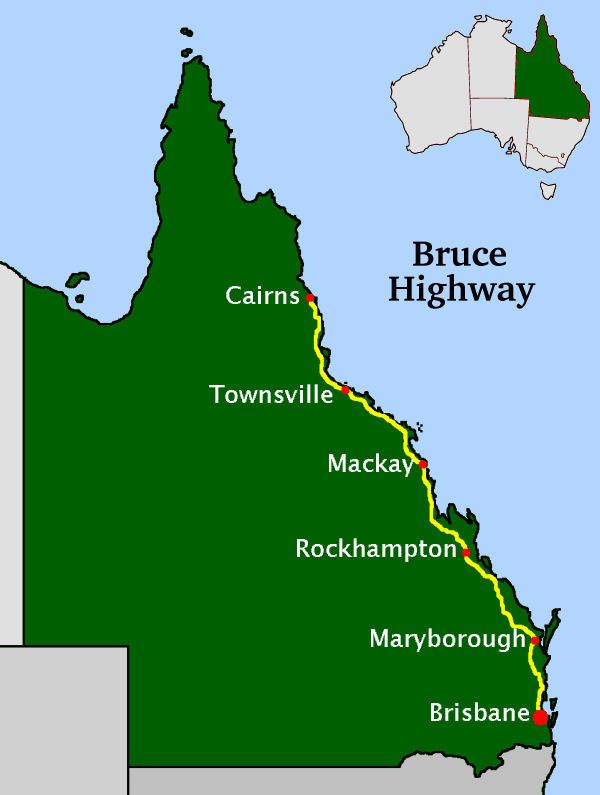
The Bruce Highway is a major highway in Queensland, Australia. Commencing in the state capital, Brisbane, it passes through areas close to the eastern coast to Cairns in Far North Queensland. The route is a part of the Australian National Highway and also part of Highway 1. Its length is approximately 1,700 kilometres (1,100 mi); it is entirely sealed with bitumen.
Map of Bruce Hwy, Queensland, Australia
The highway is named after the former Queensland and federal politician Henry Adam Bruce. He was the state Minister for Works when the highway was named after him, in the mid-1930s. It once passed through Brisbane, but was truncated at Bald Hills when the recently constructed Gateway Motorway became National Highway 1 upon its opening in December 1986.
The Bruce Highway is the biggest traffic carrier in Queensland. The highway initially joined all the major coastal centres; however, a number of bypasses, particularly in the south, have diverted traffic around these cities to expedite traffic flow and ease urban congestion. As a result, the highway is constantly being shortened. The road is a dual carriageway from Brisbane to Cooroy with some dual carriageway lengths at Gympie, many of these upgrades being completed in the 1980s (Glass House Mountains, Tanawha, Maryborough) and 1990s (Nambour, Yandina, and Cooroy).
In the south the Bruce Highway commences at the bridge over the Pine River at the Gateway Motorway interchange, 21 kilometres (13 mi) north of Brisbane central business district. Recently, the Bruce Highway has changed its route numbering from National Highway 1 to the M1 (motorway road) or A1 (single carriageway, generally with overtaking lanes).
Several major cities along the route include Maryborough, Rockhampton, Mackay, Townsville, and Cairns. The highway passes the Glasshouse Mountains, rainforests and pastures in the Sunshine Coast, the Gunalda Range (north of Gympie), Mount Larcom (north of Gladstone), and the arid countryside north of Rockhampton; after that, it passes through land predominantly used for sugar cane, crop growing and dairy farms and the sub-tropics and tropics.
One of the largest and major deviations of the Bruce Highway was the Bald Hills to Burpengary Deviation. Beginning construction in 1972, the new route took traffic from Gympie Road at Bald Hills to Uhlmann Road at Burpengary along a much more superior alignment which was also constructed to four lanes. The new route was officially opened on 10 November 1977 at a total cost of $20 million.
Due to the nature of wet weather and tropical cyclone prone areas of North Queensland, Bruce Highway is prone to frequent flooding in a number of places. Following the catastrophic Queensland floods in 2010–2011 the Australian Government have commissioned a feasibility study on flood-proofing the Bruce Highway. The feasibility study is to be completed by the middle of 2011.
Bruce Highway is set to undergo redevelopment, realignment, flood-proofing and extension of dual carriageway sections on numerous stretches of the Highway. Former Premier Anna Bligh announced the plans while launching the Queensland Infrastructure Plan. The works are expected to total A$2 billion and include 60 projects over a period of two decades.
A stretch of road between Cardwell and Tully, which is prone to frequent flooding in the wet season, is set to undergo realignment. A new route for the highway through Townsville was under construction with the first stage of the Townsville Ring Road (now called The Ring Road) already completed.
Upgrade to a stretch of the highway north of Townsville has been given approval, and will see the existing dual carriageway to the north extended by another 5–10 km. It will also include installation of traffic lights at Mt Low Parkway, and will be the final stage of the Ring Road link up to this section by 2015. The Queensland Main Roads Department's ultimate concept map of the development also shows that the highway will also progressively become Motorway standard by 2015, with the implementation of interchanges at various junctions.
The highway south of Cairns will also see sections of the highway to the suburb of Edmonton become six lanes, with progressive dual-carriageway redevelopment of the highway to Gordonvale. Labour candidate Jim Turnour has also put ahead that stage 1 of the Cairns Southern Motorway will begin with overpasses at Ray Jones Drive and Sheehy Road if elected.
To improve flood immunity of the highway south of Childers, a new and improved road alignment and a higher bridge over the Isis River were completed in September 2011.
Between Caboolture and the Gateway Motorway, the highway has been widened to eight and six lanes since 2001, including the Dohles Rocks Road to Boundary Road section in October 2004, the Boundary Road to Uhlmann Road section in March 2007, and the latest section Uhlmann Road to Bribie Island Road in November 2009. Further upgrades are under review.
A new interchange is currently under construction at the notorious intersection of Roys Road at Beerwah. It will also connect to the nearby Bells Creek Road, another dangerous intersection, and is due for completion in early 2015. This follows a similar situation at Buchanans Road in Morayfield, the intersection of which was replaced by an interchange in November 1996.
The Pumicestone Road interchange is also undergoing a redesign, replacing the original low-level bridge and ramps constructed in October 1970. Completion is expected in late 2014.
The Nambour Bypass has recently gone through a process of rehabilitation due to the extremely rough surface and dangerous pothole appearances during wet weather. This work was completed in 2009.
As of 2014 Section B of the joint State and Federal funded 61 kilometres (38 mi) Cooroy to Curra upgrade of the highway is open. Due to the new highway change, one of the local schools, Federal State School, was relocated. Early works for Section A has commenced. When completed, the Cooroy to Curra upgrade will bypass the town of Gympie and a mainly 2 lane section will be replaced with a 4 lane dual-carriageway.
August 1966 - Caboolture Bypass Stage 1. Single-carriageway completed between Burpengary Creek and Bribie Island Road.August 1970 - Caboolture Bypass Stage 2. Single-carriageway completed between Bribie Island Road and Red Road.December 1972 - Single-carriageway deviation between Eumundi and Cooroy, bypassing Eumundi Range Road.December 1973 - Bald Hills to Burpengary Deviation Stage 1. 1.3 mile-long dual-carriageways completed between Roghan Road and Strathpine Road.December 1973 - Beerwah Bypass. 2.5 km-long deviation completed between Roys Road and Foley Road including a new concrete bridge across Coochin Creek.November 1974 - Browns Creek Deviation. 6 km-long single-carriageway completed between Browns Creek and Eerwah Vale.December 1974 - Glasshouse Mountains Bypass. 1.5 km-long deviation completed between Glasshouse Mountains Sportsground and Kings Road including a new concrete bridge across Coonowrin Creek.August 1976 - Eumundi Bypass. 2.4 km-long deviation completed between Eerwah Vale and Main Creek.2 August 1976 - Bald Hills to Burpengary Deviation Stage 2. 12 km-long single-carriageway deviation completed between Strathpine Road and Boundary Road.March 1977 - Bald Hills to Burpengary Deviation Stage 3. Second carriageway completed between Strathpine Road and Anzac Avenue.10 November 1977 - Bald Hills to Burpengary Deviation Stage 4. Boundary Road to Deception Bay Road section completed.5 December 1978 - Bribie Island Road Interchange.9 August 1979 - Burpengary to Bribie Island Road Duplication. Second carriageway completed between Burpengary Creek and Bribie Island Road.9 December 1985 - Beerburrum Creek to Caloundra Road Deviation. Major 26.5 km-long four lane deviation completed between Beerburrum Creek and Caloundra Road.September 1987 - Caloundra Road to Sippy Creek duplication16 November 1989 - Tanawha Deviation. Four lane deviation completed between Caloundra Road and Maroochydore Road.23 November 1990 - Nambour Bypass Stage 1. Single-carriageway bypass of Nambour completed between Maroochydore Road and Parklands.20 December 1993 - Nambour Bypass Stage 2. Second carriageway completed between Maroochydore Road and Parklands.17 May 1994 - Cooroy Bypass. Single-carriageway bypass of Cooroy completed.13 July 1997 - Yandina Bypass. Dual-carriageway bypass of Yandina completed.23 July 2002 - Gateway Motorway to Dohles Rocks Road six-laning.18 September 2003 - Yandina to Cooroy Duplication. Dual-carriageways completed between Browns Creek and Eumundi Range.20 January 2005 - Dohles Rocks Road to Boundary Road six-laning. Six-lane upgrade completed between Dohles Rocks Road and Boundary Road, including upgrades to the Anzac Avenue interchange.12 March 2007 - Boundary Road to Uhlmann Road six-laning. Six-lane upgrade completed between Boundary Road and Uhlmann Road, including upgrades to the Deception Bay Road and Uhlmann Road interchanges.5 November 2009 - Uhlmann Road to Bribie Island Road six-laning. Six-lane upgrade completed between Uhlmann Road and Bribie Island Road, including upgrades to the Bribie Island Road interchange.Wallaville - Burnett River Bridge (May 1940)Ambrose to Raglan Deviation (December 1967)Gunalda Bypass (April 1973)Gavial Deviation (Rockhampton) - Roope Road to Egan's Hill (1974)Calliope River Bridge (April 1975)Bauple Bypass (August 1976)Bajool Bypass (May 1977)Howard-Torbanlea Deviation (May 1984)Rockhampton Deviation – Yeppen Yeppen Crossing to Egan's Hill (7 October 1986)Maryborough Bypass (14 September 1990)Glenwood Deviation (16 November 1991)Wallaville Deviation - Tim Fischer Bridge (5 July 1999)Gunalda Range Deviation (14 February 2001)Isis River Bridge replacement (August 2011)Cooroy to Curra Upgrade Section B (18 December 2012)Rockhampton – Yeppen North (28 October 2013)Calliope Interchange (11 June 2014)Rockhampton - Yeppen South (22 October 2015)Cooroy to Curra Upgrade Section A (to be completed early 2017)Bowen - Don River Bridge (10 May 1973)Parkhurst - Ramsey Creek Bridge (January 1975)Mackay - Bakers Creek Deviation (23 December 1977)Mackay Deviation – Ron Camm Bridge (12 July 1980)Rockhampton Deviation – Neville Hewitt Bridge (16 August 1980)Marlborough-Sarina alignment change (29 October 1982)Thoopara - 3.4 km deviation and new bridge over O'Connell River (September 1984)Mackay City Gates - Realignment of Nebo Road at the City Gates with provision of an overpass to allow for future North Coast Railway realignment (1991)Townsville Deviation - Alignment change from Ingham/Charters Towers/Bowen Roads/Stuart Drive to Nathan/Duckworth Streets/University Road (25 May 1992)Barratta - Collinsons Lagoon realignment (July 1993)Barratta - Middle and East Barratta Creek realignments (December 1993)Yaamba/Milman Deviation - new alignment with higher-level bridges at Alligator and Plentiful Creeks in response to 1991 Flood (20 April 1994)Townsville - Charles N. Barton Bridge Duplication (1995)Mackay - Ron Camm Bridge duplication (18 December 1998)Mackay - Boundary Road to Farrellys Lane duplication and intersection upgrade (December 2009)Mackay - Boundary Road to City Gates intersection upgrades (2012)Mackay - Farrellys Road to Temples Lane duplication and intersection upgrades (October 2013)Brandon - Sandy Corner to Collinsons Lagoon realignment for flood mitigation and cane rail overpass (February 2015)Townsville - Vantassel Street to Cluden Drive duplication, rail overpass and intersection upgrades (October 2015).Gordonvale/Aloomba Bypass Stage 1: Swan Creek to Riverstone Road, including Carl Wordsworth Bridge (1959)Gordonvale/Aloomba Bypass Stage 2: Mackey's Creek to Riverstone Road, bypass of Gordonvale (1961)Rollingstone Deviation (1962)Gordonvale/Aloomba Bypass Stage 3: Swan Creek to Leumann Road, bypass of Aloomba (1963)Gordonvale/Aloomba Bypass Stage 4: Leumann Road to Assman Road (1966)Bellenden Ker Deviation (1968)Ingham Deviation - John Row Bridge at Herbert River (28 September 1968)Bellenden Plains/Murray River Deviation - replaced in 2008 by Tully Deviation (December 1968)Townsville - Black River Bridge (October 1971)Innisfail Deviation – Centenary Bridge (9 July 1973)Innisfail - Sir Joseph McAvoy Bridge (1981)Rollingstone Creek - High-level bridge (10 November 1984)Cardwell Range Deviation (South) (23 April 1987)Mutarnee - Ollera Creek Bridge and Mutarnee Deviation (4 December 1987)Babinda Deviation Stage 1: Lloyd's Corner/Stager Road to Munro Street (17 October 1991)Babinda Deviation Stage 2: Munro Street to Nelson Road (1992)Babinda Deviation Stage 3: Nelson Road to Frenchmans Creek (1993)Townsville Deviation – Woolcock Street extension (March 1998)Edmonton Deviation - realignment and four-laning (1999)Cairns - Ray Jones Drive to Sheehy Road six-laning (2002)Cairns - Sheehy Road to Foster Road six-laning (2004)Tully deviation (2008)Townsville Ring Road Stage 3 - Change of course for National Highway A1 (17 April 2009)Higher-level Mulgrave River Bridge - Desmond Trannore Bridge (20 April 2009)Mount Low Overpass Townsville (June 2009)Cardwell Range Deviation (North) (1 November 2013)Cairns Southern Access Upgrade – Stage 1 (May 2014)Cairns Southern Access Upgrade – Stage 2: Foster Road to Robert Road six-laning (In progress as of June 2016Townsville Ring Road Stage 4 - Change of course for National Highway A1 (Completed December 2016)Travelling north, the following towns and small cities are found on (or very close to) the Bruce Highway.
Brisbane to MaryboroughCaboolture (bypassed in 1969/1970)Nambour (bypassed in 1990)EumundiCooroyGympieMaryborough to RockhamptonChildersGin GinMiriam ValeCalliopeMount LarcomAmbroseRaglanMarmorBajoolRockhampton to MackayThe CavesYaambaMarlboroughSarinaMackay to TownsvilleProserpineBowenHome HillAyrTownsville to CairnsInghamCardwellTullyInnisfail