
Type Highway Constructed 1955 | Length 14,500 km (9,010 mi) | |
 | ||
Similar Spreuerhofstraße, Peats Ferry Bridge, Hinchinbrook Island, Australian Arid Lands Botanic G, Mooney Mooney Bridge | ||
Australia's Highway 1 is a network of highways that circumnavigate the country, joining all mainland state capitals. At a total length of approximately 14,500 km (9,000 mi) it is among the longest national highways in the world, a list also including the Trans-Siberian Highway (over 11,000 km or 6,800 mi) and the Trans-Canada Highway (8,030 km or 4,990 mi). Every day more than a million people travel on a part of it.
Contents
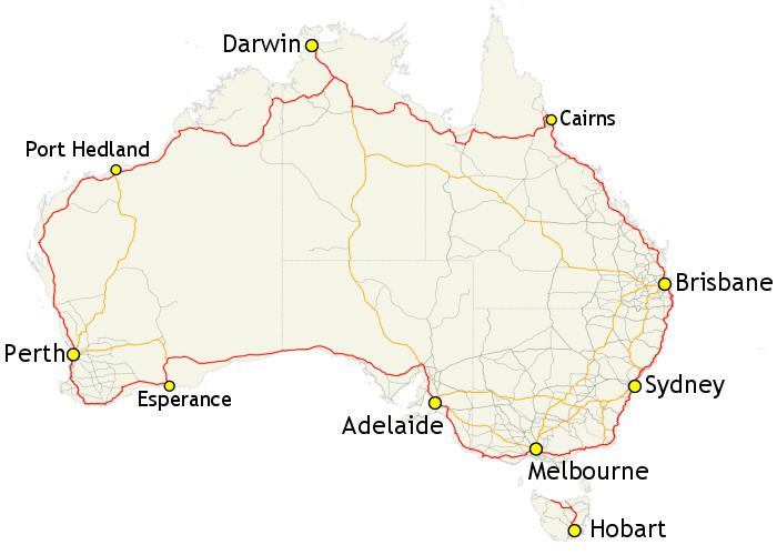
Map of National Route 1, Australia
History
Highway 1 was created as part of the National Route Numbering system, adopted in 1955. The route was compiled from an existing network of state and local roads and tracks. Highway 1 is the only route to reach across all Australian states and territories, with the exception of the Australian Capital Territory. Many of the other national routes are tributaries of Highway 1.
Under the original Highway 1 scheme, certain major traffic routes that ran parallel to the main route were designated National Route Alternative 1. Most of these route designations have been replaced by either a state route designation, or an alpha-numeric route designation, depending on which state the section is in. An example of the Alternative 1 designation remaining is on the old Princes Highway route from Dandenong to South Melbourne in Victoria.
Route markers
The entirety of Highway 1 was originally marked with a National Route 1 shield (black number on a white shield). In 1974, the segments of the route that were declared part of the National Highway network were updated to use the National Highway shield (gold number on a green shield).
Since that time, all states and territories except for Western Australia have adopted (or are in the process of adopting) alphanumeric route numbers. As a consequence, much of Highway 1 is now marked with a M1, A1 or B1 route marker (depending on the route's quality and importance). A notable exception is in Tasmania, which was the first state to adopt alphanumeric route numbers but Highway 1 is still marked with a National Highway 1 shield.
In South Australia, sections of Highway 1 which were once part of the National Highway are marked as A1 or M1 but retain the National Highway "shield".
Track
From Sydney, it heads southwards to Melbourne and then on to Adelaide via the Eastern Distributor, Southern Cross Drive, General Holmes Drive, The Grand Parade, President Avenue, Princes Highway (NSW), Princes Motorway, Princes Highway (VIC), Princes Freeway (east), Monash Freeway, CityLink, West Gate Freeway, Princes Freeway (west), Geelong Ring Road, Princes Highway (SA). From then on to Perth via Port Wakefield Road, Augusta Highway, Eyre Highway, Coolgardie-Esperance Highway, South Coast Highway and South Western Highway. It then heads to Darwin via Brand Highway, North West Coastal Highway, Great Northern Highway, Victoria Highway, and Stuart Highway.
From Darwin, Highway 1 follows the Stuart Highway to Daly Waters, and thereafter the Carpentaria Highway to Borroloola. The Savannah Way is the largely unsignposted route for Highway 1 between the QLD/NT border, east of Borroloola, and Normanton, Queensland.
From there, it follows the Gulf Developmental Road and Kennedy Highway to Cairns and southwards via Bruce Highway to Brisbane and then back to Sydney via the Pacific Motorway (QLD/NSW), Pacific Highway (NSW), Pacific Motorway (NSW), Pacific Highway (Sydney), Gore Hill Freeway, Warringah Freeway, Sydney Harbour Tunnel, and the Cahill Expressway.
In Tasmania it starts at the Brooker Highway in Hobart and heads towards Launceston via the Midland Highway. At Launceston it becomes the Bass Highway to Burnie. Highway 1 ends at Burnie; the Bass Highway continues to Marrawah on the west coast as Highway A2.
Large sections of Highway 1 are shared with the Australian National Highway, though the two are not synonymous. For instance, the Princes Highway from Sydney to Melbourne is part of Highway 1, but is not part of the National Highway, which follows the Hume Highway and Freeway.
Road conditions
With such a vast and incomparable length, road conditions vary greatly; from multi-lane freeways in populous urban and rural areas, to sealed two-laners in remote areas, such as the Nullarbor Plain, to single lane roads, such as in northern Queensland.
Some stretches are very isolated, such as the Eyre Highway, which crosses the Nullarbor Plain, and the Great Northern Highway, which runs close to the north-western coastline. Isolated roadhouses serving the small amount of passing traffic are often the only signs of human activity for hundreds of kilometres.
Highway 1 has been described as a "death trap", particularly two-lane sections in northern Queensland, due to driver fatigue. The vast distances between destinations and limited rest areas, especially those suitable to trucks, contribute to the problem.
Sights
Highway 1 covers practically every major inhabited part of Australia. Large capital cities, busy holiday resorts, dramatic coastlines, forests ranging from tropical to temperate gum forests, giant karri stands, scrubland, deserts, and huge tropical swamps are some of the variety of landscapes that can be found along the route.
Stretches of Highway 1 are very popular with interstate and overseas tourists. A drive around Highway 1 with a major detour to Uluru and back again practically covers most of Australia. The number 1 shield became part of the bush landscape to many travellers, truckers, and country people.