Type Highway Major cities Port Douglas | Length 75 km | |
 | ||
Route number(s) State Route 44 (Mossman - Smithfield)
National Route 1 (Smithfield - Cairns) North end Mossman-Daintree Road, Mossman South end Bruce Highway (National Highway A1), Cairns Major settlements Port Douglas, Palm Cove, Queensland, Smithfield, Queensland Similar Palm Cove - Queensland, Ellis Beach - Queensland, Skyrail Rainforest Cableway, Daintree Rainforest, Cape Tribulation - Queensland | ||
Captain cook highway queensland
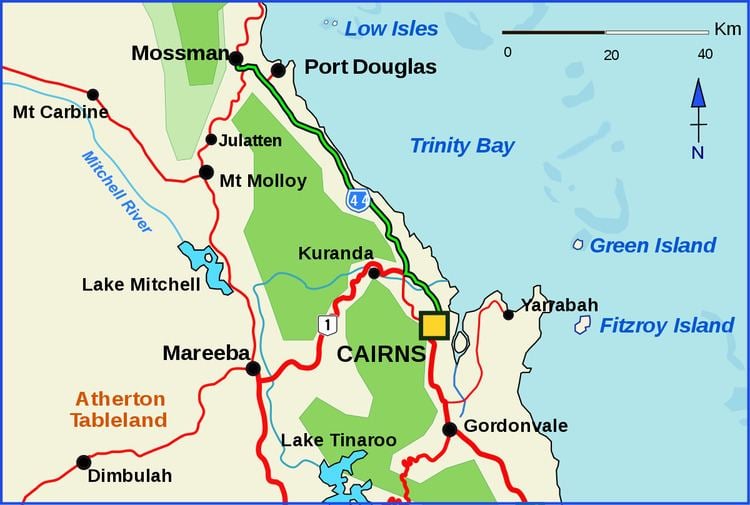
Captain Cook Highway is a short Queensland highway that starts in Cairns and ends in Mossman, where it joins Mossman-Daintree Road, which continues to Daintree.
Contents
- Captain cook highway queensland
- Map of Captain Cook Hwy Queensland Australia
- Captain cook highway coast road
- Route description
- References
Map of Captain Cook Hwy, Queensland, Australia
Captain Cook Highway is used by many tourists to travel to Port Douglas north of Cairns. Apart from being a vital link between two tourist locations, Captain Cook Highway is a scenic highway that winds alongside the coast of the tropical seaside rainforest heading towards Port Douglas and Daintree National Park.
Captain cook highway coast road
Route description
The highway commences at the end of the A1 Bruce Highway, in Cairns. It runs north through Cairns to the suburb of Smithfield as National Route 1. From there it continues as State Route 44 through the beachside suburbs of Kewarra Beach and Palm Cove, and then follows the coast to Port Douglas. It then proceeds to Mossman where it terminates.
