
Population 5,965 (2011 census) Postcode(s) 4036 Postal code 4036 | Established 1857 Area 13.9 km² | |
 | ||
Location 17 km (11 mi) from Brisbane | ||
Bald Hills is the northernmost suburb of the City of Brisbane, Queensland, Australia. At the 2011 Australian Census the suburb recorded a population of 5,965.
Contents
- Map of Bald Hills QLD 4036 Australia
- Geography
- Demographics
- History
- Landmarks
- Heritage listings
- Schools
- Facilities
- Transport
- References
Map of Bald Hills QLD 4036, Australia
Geography
Bald Hills is a largely residential suburb. It is mostly surrounded by bushland, but in the last few years some of the bush areas have been cleared to make way for new residential areas. It also borders onto the Bald Hills Flats – a large flood plain on the western side of the suburb that is used for cattle grazing. The South Pine River flows through the flood plain and forms the western border of the suburb. The South Pine River converges with the North Pine River and the combined flow, Pine River, forms the northern border. Along the banks of Pine River within Bald Hills is a large environmental park called the Tinchi Tamba Wetlands Reserve. The Pine River empties into Bramble Bay, between Redcliffe and Brighton.
Demographics
In the 2011 census, Bald Hills recorded a population of 5,965 people, 51.3% female and 48.7% male. The median age of the Bald Hills population was 35 years of age, 2 years below the Australian median. 79.1% of people living in Bald Hills were born in Australia, compared to the national average of 69.8%; the next most common countries of birth were New Zealand 3.8%, England 3.4%, Philippines 0.9%, Fiji 0.8%, Scotland 0.7%. 88.8% of people spoke only English at home; the next most popular languages were 0.8% Hindi, 0.6% Tagalog, 0.4% Tongan, 0.4% Spanish, 0.3% Arabic.
History
The suburb is named after the two small hills in the South Pine River Valley floor. The first land sales in the area occurred in 1857. Land sales around the Bald Hills railway station were advertised in April 1886. At the time the journey from Brisbane was described as "after travelling across the Downfall and Cabbage Tree Creeks, the traveller arrives at a long stretch of road, at the extremity of which rises a lofty knoll, round the brow of which the road winds, when the Bald Hills are reached". Bald Hills State School opened on 24 September 1866.
Landmarks
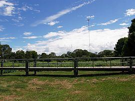
The most prominent structure is the Bald Hills Radiator, the ABC's 198 metre tall AM radio transmission tower located on the eastern side of the suburb. Bald Hills is the home of the Bald Hills-Lawnton Lions Cricket Club, as well as Ridge Hills United Football Club.
Heritage listings
Bald Hills has a number of heritage-listed sites, including:
Schools
There are two schools in the suburb, Bald Hills State School, a state primary school and St Paul's School, an Anglican co-educational private school from Prep to Year 12. Bald Hills Primary School began teaching students in 1866 making it the fourth school to open in the state.
Facilities
Bald Hills is also home to the breeding and training centre for Guide Dogs for the Blind Association of Queensland.
Transport
Bald Hills railway station provides access to regular Queensland Rail City network services to Brisbane and Ipswich, as well as Caboolture and the Sunshine Coast. There are also many buses serving the area. The suburb is crossed by both Gympie Road and the northern end of the Gateway Motorway. The southern end of the Bruce Highway is located here as well.