
Population 19,346 (2011 census) LGA(s) Moreton Bay Region Postal code 4506 | Postcode(s) 4506 State electorate(s) MorayfieldMurrumba | |
 | ||
Morayfield BeachmereBurpengary East | ||
Morayfield is a town and suburb of Moreton Bay Region, Queensland, Australia. It is 44 kilometres (27 mi) north of Brisbane, the state capital. In the 2011 census, Morayfield had a population of 19,346 people.
Contents
- Map of Morayfield QLD 4506 Australia
- Geography
- History
- Demographics
- Heritage listings
- Transport
- References
Map of Morayfield QLD 4506, Australia
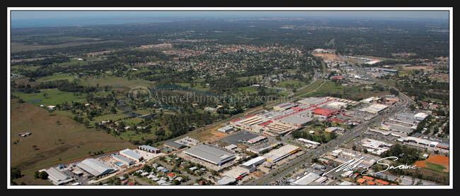
Geography
Morayfield is a mostly residential area, consisting mainly of low-set brick homes and some semi-rural acreage. The main commercial area is concentrated along Morayfield Road and includes the Morayfield Shopping Centre, which opened in 1997. The suburb is situated in the Burpengary Creek catchment area.
History
In 1868 Brisbane man George Raff bought some of the land held by the failed Caboolture Cotton Company, calling it "Moray Field", derived from Raff's native Morayshire in Scotland. It was often written as "Morayfields" and, from 1881, became "Morayfield".
Until the mid-1980s, Morayfield remained a rural area consisting of a small dairy holding and small crop farming enterprises. However, with the population pressure caused by the rapid growth of the greater Brisbane area, it has since suffered to some degree from random or unplanned residential development and rapid population growth. It is a thriving retail and service industry commercial center.
Greg Norman is currently involved in a large-scale plan to radically alter the eastern fringes of Morayfield, with land to the east of the Bruce Highway and south of the Caboolture River is to be turned into medium density residential lots.
In January 2011 parts of Morayfield were flooded during the 2010-2011 Queensland floods.
Demographics
In the 2011 census, Morayfield recorded a population of 19,346 people, 50.9% female and 49.1% male.
The median age of the Morayfield population was 31 years, 6 years below the national median of 37.
78.8% of people living in Morayfield were born in Australia. The other top responses for country of birth were New Zealand 5.1%, England 3.9%, Scotland 0.6%, Philippines 0.6%, South Africa 0.4%.
90.6% of people spoke only English at home; the next most common languages were 0.6% Samoan, 0.2% Tagalog, 0.2% Dutch, 0.2% German, 0.2% Italian.
Heritage listings
Morayfield has a number of heritage-listed sites, including:
Transport
Morayfield railway station provides access to regular Queensland Rail City network services to Brisbane and Ipswich, as well as Caboolture and the Sunshine Coast. Morayfield Road is a major road that passes through both Morayfield and Caboolture, most of the regions shops are situated on this major road, including the Morayfield Shopping Centre.