
Country Area 25,877 km2 Governor Svein LudvigsenHøyre Population 161.771 | Language spoken NOK Region | |
 | ||
Points of interest Arctic Cathedral, Polaria, Tromsø University Museum, Tromsøya, Øvre Dividal National Park Colleges and Universities University of Tromsø (Tromsø), Harstad University College (Harstad), Norwegian College of Fishery Science (Tromsø), Tromsø University College (Tromsø), Tromsø University Business School (Tromsø) | ||
Mayor Knut Werner Hansen Ap (2011–present) | ||
Map of Troms
Troms ([trums]; Northern Sami: Romsa, Finnish: Tromssa) is a county in Northern Norway. It borders Finnmark county to the northeast and Nordland county in the southwest. Norrbotten Län in Sweden is located to the south and further southeast is a shorter border with Lapland Province in Finland. To the west is the Norwegian Sea (Atlantic Ocean).
Contents
- Map of Troms
- Troms the arctic city
- Troms troms county norway
- Name
- Coat of arms
- Geography
- Climate
- Sunlight
- Nature
- Economy
- History
- Demographics
- Municipalities
- Food and winter activities tromso arctic norway
- References
The entire county, which was established in 1866, is located north of the Arctic circle. The Troms County Municipality is the governing body for the county, elected by the people of Troms, while the Troms county governor is a representative of the King and Government of Norway. The county had a population of 161,771 in 2014.
Troms the arctic city
Troms troms county norway
Name
Until 1919 the county was formerly known as Tromsø amt. On 1 July 2006, the Northern Sami name for the county, Romsa, was granted official status along with Troms.
The county (and the city of Tromsø) is named after the island Tromsøya on which it is located (Old Norse Trums). Several theories exist as to the etymology of Troms. One theory holds "Troms-" to derive from the old (uncompounded) name of the island (Old Norse: Trums). Several islands and rivers in Norway have the name Tromsa, and the names of these are probably derived from the word straumr which means "(strong) stream". (The original form must then have been Strums, for the missing s see Indo-European s-mobile.) Another theory holds that Tromsøya was originally called Lille Tromsøya (Little Tromsøya), because of its proximity to the much bigger island today called Kvaløya, that according to this theory was earlier called "Store Tromsøya" due to a characteristic mountain known as Tromma (the Drum). The mountain's name in Sámi, Rumbbučohkka, is identical in meaning, and it is said to have been a sacred mountain for the Sámi in pre-Christian times.
The Sámi name of the island, Romsa, is assumed to be a loan from Norse – but according to the phonetical rules of the Sami language the frontal t has disappeared from the name. However, an alternative form – Tromsa – is in informal use. There is a theory that holds the Norwegian name of Tromsø derives from the Sámi name, though this theory lacks an explanation for the meaning of Romsa. A common misunderstanding is that Tromsø's Sámi name is Romssa with a double "s". This, however, is the accusative and genitive form of the noun used when, for example, writing "Tromsø Municipality" (Romssa Suohkan).
Coat of arms
The coat of arms of Troms was made by Hallvard Trætteberg (1898–1987), and adopted by royal resolution on 15 January 1960. The official blazon in Norwegian ("På rød bunn en gull griff") translates to "On a field Gules a griffin [segreant] Or." Trætteberg chose to have the griffin as charge because that animal was the symbol of the mighty clan of Bjarne Erlingsson on Bjarkøy in the 13th century.
Geography
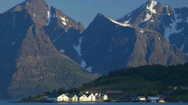
Troms is located in the northern part of the Scandinavian peninsula. Due to the long distance to the more densely populated areas of the continent, this is one of the least polluted areas of Europe. Troms has a very rugged and indented coastline facing the Norwegian Sea. However, the large and mountainous islands along the coast provide an excellent sheltered waterway on the inside. Starting in the south, the largest islands are: northeastern part of Hinnøya (the southern part is in Nordland), Grytøya, Senja, Kvaløya, Ringvassøya, Reinøy, Vannøy, and Arnøy. Some of these islands, most noteworthy Senja, have a rugged outer coast with steep mountains, and a more calm eastern shore. There are several large fjords that stretch quite far inland. Starting in the south, the largest fjords are Vågsfjorden, Andfjorden (shared with Nordland), Malangen, Balsfjord, Ullsfjord, Lyngen, and Kvænangen (fjord). The largest lake is Altevatnet in the interior of the county.
There are mountains in all parts of Troms; the most alpine and striking are probably the Lyngen Alps (Lyngsalpene), with several small glaciers and the highest mountain in the county, Jiekkevarre with a height of 1,833 m (6,014 ft). Several glaciers are located in Kvænangen, including parts of the Øksfjordjøkelen, the last glacier in mainland Norway to drop icebergs directly into the sea (in the Jøkelfjord). The largest river in Troms (waterflow) is Målselva (in Målselv), and the largest (not the highest) waterfall is Målselvfossen at 600 m (2,000 ft) long and 20 m (66 ft) high. Marble is present in parts of Troms, and thus numerous caves, as in Salangen and Skånland.
Climate
Located at a latitude of nearly 70°N, Troms has short, cool summers, but fairly mild winters along the coast due to the temperate sea; Torsvåg Lighthouse in Karlsøy has January 24-hr average of −1 °C (30 °F). Tromsø averages −4 °C (25 °F) in January with a daily high of −2 °C (28 °F), while July averages 12 °C (54 °F) with high of 15 °C (59 °F). Temperatures are typically below freezing for about 5 months (8 months in the mountains), from early November to the beginning of April, but coastal areas are moderated by the sea: with more than 130 years of official weather recordings, the coldest winter temperature ever recorded in Tromsø is −20.1 °C (−4.2 °F) in February 1985. The all-time high for Troms is 32.7 °C (90.9 °F) recorded in Skibotn July 10, 2014. Thaws can occur even in mid-winter. There is often snow in abundance, and avalanches are not uncommon in winter. With the prevailing westerlies, lowland areas east of mountain ranges have less precipitation than areas west of the mountains.
Skibotn (elevation: 46 m or 151 ft) in Storfjord is the location in Norway which has recorded the most days per year with clear skies (no clouds). Winter temperatures in Målselv and Bardu can get down to −35 °C (−31 °F), while summer days can reach 30 °C (86 °F) in inland valleys and the innermost fjord areas, but 15 to 22 °C (59 to 72 °F) is much more common. Along the outer seaboard, a summer day at 15 °C (59 °F) is considered fairly warm.
Sunlight
The aurora borealis is a common sight in the whole of Troms, but not in summer as there is no darkness. As with all areas in the polar latitudes, there are extreme variations in daylight between the seasons. As a consequence of this, the length of daylight increases (late winter and spring) or decreases (autumn) with 10 minutes from one day to the next.
Nature
Moose, red fox, hare, stoat, and small rodents are common in all of Troms county. Brown bears are sighted in the interior parts of the county in the summer. Other animals that can be seen are reindeer (interior mountain areas, with Sami owners), wolverine (interior mountain areas), otters (along the coast and rivers), lynx (in the forests), and harbour porpoises in the fjords. Sperm whales, killer whales and humpback whales are often seen in Andfjorden. Some of the common birds are ptarmigan, sea eagles, seagulls, and cormorants.
The sheltered valleys in the interior of Troms have the highest tree line (summer warmth and length is the limiting factor), with downy birch reaching an elevation of 700 m (2,300 ft) on the southern slope of Njunis; all over Troms county birch trees forms the tree lines, often 200 metres (660 ft) above other trees. Rowan, aspen, willow, grey alder, and bird cherry are common in the lower elevations.
Scots pine reaches an elevation of almost 400 m (1,300 ft) in Dividalen, where some of the largest trees are 500 years old. The upper part of the valley is protected by Øvre Dividal National Park, which was enlarged in 2006. In 2011, the Rohkunborri National Park (571 square kilometres or 220 square miles) was established in Bardu municipality, bordering Sweden and only a few kilometers south of Øvre Dividal National Park.
The inland valleys, like Østerdalen (with Altevatnet), Kirkesdalen, Dividalen, Rostadalen, Signaldalen, and Skibotndalen, are perfect for summer hiking, with their varied nature, mostly dry climate and not too difficult terrain, although there are many accessible mountains for energetic hikers.
Reisadalen is one of the most idyllic river valleys in Norway; from Storslett in Nordreisa the valley stretches south-southeast, covered with birch, pine, grey alder, and willow. The northern part of the valley is 5 km (3.1 mi) wide, with 1,200-metre (3,900 ft) high mountains on both sides; the southern part of the valley narrows to a few hundred metres (canyon), with increasingly dry climate. The valley floor is fairly flat with little height difference for 70 km (43 mi) (to Bilto); the Reisa river can be navigated by canoe or river boat for much of this distance. The salmon swim 90 km (56 mi) up the river, and some 137 different species of birds have been observed. Several rivers cascade down into the valley; the Mollisfossen waterfall is 269 m (883 ft). The valley ends 120 km (75 mi) southeast of Storslett, as the vast and more barren Finnmarksvidda plateau takes over. Reisa National Park protects the upper part of the valley.
Economy
The city of Tromsø, in the north central part, is the county seat and an Arctic seaport, and seat of the world's northernmost university, renowned for research about the aurora borealis. The University of Tromsø has an astrophysical observatory located in Skibotn ([1]). Tromsø is the only municipality in the county with a strong population growth; most of the smaller municipalities experience decreasing populations as the young and educated move to the cities, often in the southern part of Norway. Harstad is a commercial centre for the southern part of the county, and has been chosen by Statoil as its main office in Northern Norway.
Along the coast and on the islands, fishing is dominant. Important ports for the fishing fleet are Skjervøy, Tromsø and Harstad. There is also some agriculture, especially in the southern part, which has a longer growing season (150 days in Harstad). Balsfjord is often regarded to be the most northern municipality with substantial agricultural activity in Norway, although there is also agriculture further north.
The Norwegian armed forces is a vital employer in Troms, having the seat of the 6th army division, Bardufoss Air Station, helicopter wings and radar stations in the county. There are hospitals in Tromsø (university hospital and main hospital for North Norway) and Harstad.
The busiest airport is Tromsø Airport. The southern part of Troms is served by Harstad/Narvik Airport, Evenes and Bardufoss Airport, and in northeast there is Sørkjosen Airport. The E6 cuts through the county from Nordland into Gratangen in the south to Kvænangen in the north and then into Finnmark. The E8 road runs from Tromsø to Finland via Nordkjosbotn and the Skibotn valley. There are several large bridges; some of the largest are Tjeldsund Bridge, Mjøsund Bridge, Gisund Bridge, Tromsø Bridge and Sandnessund Bridge. There are several undersea road tunnels; Rolla to Andørja (in Ibestad), Tromsøya to the mainland (Tromsø), Kvaløya to Ringvassøya and Skjervøy to the mainland. The roads are well maintained, but have to go long detours around fjords. For this reason passenger boats are fairly popular, for example between Tromsø and Harstad, and there are also commercial flights inside Troms.
There is no railway in Troms. But the government of Finland has expressed interest in building a railway from the Finnish rail network to port facilities at Skibotn, although they point out that they can't finance much of the cost.
History
Troms has been settled since the early stone age, and there are prehistoric rock carvings at several locations (for instance Ibestad and Balsfjord). These people made their living from hunting, fishing and gathering.
The first of the current ethnic groups to settle in the county were the Sami people, who inhabited Sapmi, an area much larger than today's Nordland, Troms and Finnmark counties. Archeological evidence has shown that a Norse iron-based culture in the late Roman Iron Age (200–400 AD), reaches as far north as Karlsøy (near today's Tromsø), but not further northeast.
The Norse with their iron and agriculture settled along the coast and in some of the larger fjords, while the Sami lived in the same fjord areas, usually just into the fjord and in the interior. From the 10th century, Norse settlements start to appear along the coast further north, reaching into what is today the county of Finnmark.
Southern and mid-Troms was a petty kingdom in the Viking age, and considered part of Hålogaland. Ottar from Hålogaland met King Alfred the Great around 890. The Viking leader Tore Hund had his seat at Bjarkøy. According to the sagas, Tore Hund speared King Olav Haraldsson at the Battle of Stiklestad. He also traded and fought in Bjarmaland, today the area of Arkhangelsk in northern Russia . Trondenes (today's Harstad) was also a central Viking power centre, and seems to have been a gathering place.
Demographics
The Kven residents of Troms are largely descendants of Finnish immigrants who arrived in the area before the 19th century from Finland because of war and famine. They settled mainly in the northeastern part of Troms, in the municipalities of Kvænangen, Nordreisa, Skjervøy, Gáivuotna - Kåfjord and Storfjord, and some also reached Balsfjord and Lyngen.
Municipalities
Troms county currently has a total of 24 municipalities. Bjarkøy was merged with Harstad (#6) on 1 January 2013, and that is not reflected on the map below.