
Country Norway District Nord-Troms Area rank 26 in Norway Area 2,108 km² Population 1,235 (2016) | County Troms Administrative centre Burfjord Demonym(s) Kvænangsværing Local time Sunday 12:40 PM Official language form Norwegian Language | |
 | ||
Weather -10°C, Wind S at 10 km/h, 57% Humidity Points of interest Øksfjordjøkelen, Stranda, Gullgruva | ||
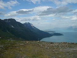
Kvænangen (Northern Sami: Návuona suohkan; Kven: Naavuonon komuuni) is a municipality in Troms county, Norway. The administrative centre of the municipality is the village of Burfjord. The European route E6 highway goes through the municipality and over the Sørstraumen Bridge, and many people stop at the Kvænangsfjellet pass to view the scenery of the Kvænangen (fjord).
Contents
- Map of KvC3A6nangen Municipality Norway
- General information
- Name
- Coat of arms
- Churches
- History
- Geography
- Climate
- Government
- Municipal council
- Notable people
- References
Map of Kv%C3%A6nangen Municipality, Norway
General information
The municipality of Kvænangen was established in 1863 when it was separated from the municipality of Skjervøy. The initial population of Kvænangen was 1,677. On 1 January 1965, the Meiland area (population: 12) of Skjervøy was transferred to Kvænangen. On 1 January 1972, the uninhabited area of Mannskarvik was transferred from Skjervøy to Kvænanagen.
Name
The municipality is named after the Kvænangen fjord (Old Norse: Kven(a)angr). The first element is the plural genitive case of kven and the last element is angr which means "fjord". The district used to be mostly populated by Sámi people.
Coat-of-arms
The coat-of-arms is from modern times (1990). The arms show three blue harebells on a gray background.
Churches
The Church of Norway has one parish (sokn) within the municipality of Kvænangen. It is part of the Nord-Troms deanery in the Diocese of Nord-Hålogaland.
History
The municipality surrounds the Kvænangen fjord, after which it is named. The population is primarily of Sami origin, although the Kven population constitutes a sizeable minority. Archeological finds indicate nomadic activity in the area going back 10,000 years.
There is evidence that Kværnangen was the site for a transitional state between nomadic and agricultural society through what was known as "siida" - delimited areas where permanent housing was established and natural resources put under stewardship.
The Kvens settled in the area in the 18th century, occupying themselves with fishing, hunting, and agriculture. Over time, fisheries became a primary industry, and the community exported dried fish to southern areas. Ethnic Norwegians gradually immigrated to facilitate trade and administration.
Norwegian public policy in the 1930s and post-war years homogenized the three groups, ethnic Norwegians, Sami, and Kven, considerably, to the point that most residents speak Norwegian at home, regardless of their ethnic heritage. Interestingly, a majority of people in Kvænangen declared themselves Sami or Kven in the 1930 census. In the 1950 census, all but a handful declared themselves Norwegian.
During the Nazi occupation during World War II, a temporary work camp was established at Kvænangen. In large part due to the generosity of the local population, prisoners had ample food. As the German Wehrmacht retreated in early 1945, the population was evacuated by force, and all buildings were burned. Today, a local museum shows typical reconstruction houses.
Geography
The municipality has coastal and plains geography, extending into Finnmarksvidda. There are mature pine forests in the valley at the head of the fjord, and there are several rivers, the largest of which is Kvænangselva, which is traditionally a good salmon-fishing river.
The Øksfjordjøkelen glacier is located in the northern part of the municipality on the border with Loppa. It's the ninth largest glacier in mainland Norway. The lake Šuoikkatjávri is located in the southern part of the municipality on the border with Kautokeino. The Langfjordjøkelen is another glacier in northern Kvænangen.
There are several islands in the fjord that are part of Kvænangen municipality: Skorpa, Spildra, and Nøklan.
Climate
climate type is dominated by the winter season, a long, bitterly cold period with short, clear days, relatively little precipitation mostly in the form of snow, and low humidity. The Köppen Climate Classification subtype for this climate is "Dfc". (Continental Subarctic Climate).
Government
All municipalities in Norway, including Kvænangen, are responsible for primary education (through 10th grade), outpatient health services, senior citizen services, unemployment and other social services, zoning, economic development, and municipal roads. The municipality is governed by a municipal council of elected representatives, which in turn elect a mayor.
Municipal council
The municipal council (Kommunestyre) of Kvænangen is made up of 15 representatives that are elected to every four years. Currently, the party breakdown is as follows:
Notable people
Notable people that were born or lived in Kvænangen include: