
Largest settlement Harstad (pop. 23,242) Area 2,205 km² | Highest elevation 1,262 m (4,140 ft) Peak Møysalen | |
 | ||
Points of interest Møysalen National Park, Møysalen, Trondenes Historical Center, Sør‑Troms museum, Møysalen Nasjonalparksenter | ||
Hinnøya is the fourth-largest island in Norway – and the largest off the mainland – covering an area of 2,204.7 square kilometres (851.2 sq mi). It is located on the west coast of the country, in Northern Norway. The western part of the island is in the district of Vesterålen, the southwestern part is in Lofoten, the southeastern part is in Ofoten and the northeastern part is in Southern Troms. In 2001, Hinnøya was Norway's most populated island.
Contents
Map of Hinn%C3%B8ya, Norway
Name
The Old Norse form of the name was just Hinn (-øya meaning 'the island' was added later). The large island is almost divided in two parts by the Gullesfjorden and Kanstadfjorden, and the old name is probably derived from an old verb with the meaning "cleave", "split", or "cut".
Environment
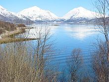
Hinnøya is dissected by several fjords, and two very long ones, Gullesfjorden in the Northeast and Øksfjorden in the Southwest, almost sever the island; it is only 5 km (3 mi) between their respective heads. The island contains a mostly rugged and mountainous terrain, especially the southern part. The best agricultural area is in the northeast, in Harstad and Kvæfjord. The southern part is the location of Møysalen National Park, which includes the highest mountain on the island, the 1,262-metre (4,140 ft) tall Møysalen. In the northwestern part of the island, near Forfjord, is a nature reserve containing a valley with forests and bogs, including the oldest pine trees in Norway, more than 700 years old.
Hinnøya is connected to the mainland by the Tjeldsund Bridge across the Tjeldsundet strait. To the west, it is connected to the island of Langøya by the Sortland Bridge, and to the northwest to the island of Andøya by the Andøy Bridge. The Lofoten mainland connection was opened on 1 December 2007. It is part of the European Route E10 highway, and it connects Hinnøya to the Lofoten islands to the southwest. The highway runs near Møysalen National Park. There is also a ferry connection in the southeast between Lødingen and Bognes on the mainland, across the Vestfjorden.
Geographic data
As of 2001, Hinnøya had a population of 32,101; the only town is Harstad. Villages include Borkenes, Lødingen, Sigerfjord and Sørvik. The island is split between the municipalities of Harstad and Kvæfjord in Troms county, as well as Andøy, Hadsel, Lødingen, Sortland, Tjeldsund and Vågan in Nordland county.
Climate
Borkenes in Kvæfjord (elevation: 36 metres or 118 feet) has mean annual temperature of 4 °C (39 °F) and mean annual precipitation 820 millimetres (32 in). The southern coast of the island in Lødingen municipality is wetter with up to 1,800 millimetres (71 in) precipitation annually.