
Country Norway District Midt-Troms Area rank 221 in Norway Area 458 km² Population 2,214 (2012) Official language form Norwegian Language | County Troms Administrative centre Sjøvegan Demonym(s) Salangsværing Local time Wednesday 10:58 AM Administrative center Sjøvegan | |
 | ||
Weather -5°C, Wind W at 14 km/h, 76% Humidity | ||
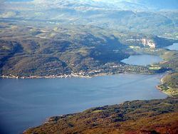
Salangen is a municipality in Troms county, Norway. The administrative centre of the municipality is the village of Sjøvegan, where most of the people in the municipality live. Other villages include Elvenes, Laberg, and Seljeskog.
Contents
- Map of Salangen 9350 Norway
- General information
- Name
- Coat of arms
- Churches
- Geography
- Geology
- Government
- Municipal council
- References
Map of Salangen, 9350, Norway
The municipality is situated along the Sagfjorden in south central Troms county. The municipality is mostly coastal areas around the fjord as well as some inland valleys. Salangen is home to the world's northernmost bat population.
General information
Salangen was established on 1 January 1871 when it was separated from the municipality of Ibestad. The initial population of Salangen was 1,384.
On 1 January 1964, the municipality of Lavangen (population: 1,677) was merged into Salangen. The new, larger Salangen then had a population of 4,288.
On 1 January 1977, however, the Lavangen district (except for Lavangsnes) was separated from Salangen to form a separate municipality once again. After the split, Salangen remained with 2,611 residents.
Name
The municipality is named after the Salangen fjord (Old Norse: Selangr). The first element is selr which means "seal" and the last element is angr which means "fjord".
Coat-of-arms
The coat-of-arms is from modern times. They were granted on 2 December 1985. The arms show a seal on a blue background. They are canting arms since the name of the municipality is derived from the old word "Sellanger", meaning seal fjord.
Churches
The Church of Norway has one parish (sokn) within the municipality of Salangen. It is part of the Indre Troms deanery in the Diocese of Nord-Hålogaland.
Geography
The municipality is located in the southern part of Troms county, at the northeastern end of the Astafjorden. The municipality of Ibestad is located west of Salangen, connected by the Mjøsund Bridge; Lavangen municipality to the south; Bardu to the east; and Dyrøy and Sørreisa to the north.
Geology
The area itself is part of the Caledonian Orogeny formed of part of a series of Nappes that run down the coast of Norway. These nappes were metamorphosed as a result of partial subduction beneath Laurentia during the early to middle Paleozoic. On a smaller scale, the municipality is located mainly on quartzite (known as Sjøvegan quartzite locally and regionally as Bø quartzite). In the hills to the south, there is garnet-rich schist (known as Trollvannet schist).
Across the nearby lake Nervatnet and towards the village of Strokkenes, granite within marble is present (Høglund marble and Strokkenes granite). This granite is Leucratic, an indicative sign of granite intruded within an orogenic mountain building event.
Government
All municipalities in Norway, including Salangen, are responsible for primary education (through 10th grade), outpatient health services, senior citizen services, unemployment and other social services, zoning, economic development, and municipal roads. The municipality is governed by a municipal council of elected representatives, which in turn elect a mayor.
Municipal council
The municipal council (Kommunestyre) of Salangen is made up of 19 representatives that are elected to every four years. Currently, the party breakdown is as follows: