
Primary outflows Barduelva Max. length 38 kilometres (24 mi) Surface area 79.71 km (30.78 sq mi) Max depth 99 m Area 79.71 km² Width 2 km | Max. width 2 kilometres (1.2 mi) References NVE Surface elevation 489 m Length 35 km Outflow location Barduelva | |
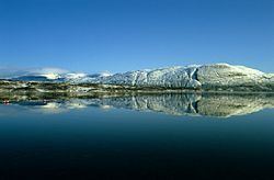 | ||
Altevatnet (Northern Sami: Álddesjávri) is Norway’s 11th largest lake at 79.71 square kilometres (30.78 sq mi). The lake is approximately 38 kilometres (24 mi) long and about 2.5 kilometres (1.6 mi) wide. It is located in the municipality of Bardu in Troms county. It is also the largest lake in Troms county. The lake is regulated by a dam on the northwestern end of the lake. The surface lies 489 metres (1,604 ft) above sea level.
Map of Altevatnet, 9360 Bardu, Norway
The lake lies about 10 kilometres (6.2 mi) from Sweden and it is located right between the two national parks: Øvre Dividal National Park and Rohkunborri National Park. The water discharges to the north into the Barduelva river, which empties into Målselva river, which in turn empties into the Malangen fjord.
References
Altevatnet Wikipedia(Text) CC BY-SA