
Existed: 1956 – present Length 438.9 km | Constructed 1956 | |
 | ||
Majorjunctions: SR 37 in Fishers I-469 / US 33 in Fort Wayne US 24 / US 30 / US 33 / US 27 in Fort Wayne I-469 / US 24 / US 30 in Fort Wayne I-80 / I-90 / Indiana Toll Road near Angola Counties Vanderburgh County, Indiana, Warrick County, Indiana | ||
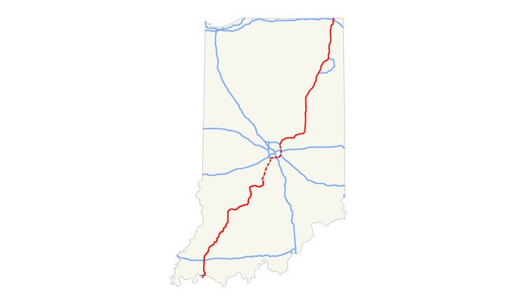
Interstate 69 (I-69) presently has two discontinuous segments of freeway in the U.S. state of Indiana. The original 157.30-mile-long (253.15 km) highway, completed in November 1971, runs northeasterly from the state capital of Indianapolis, to the city of Fort Wayne, and then proceeds north to the state of Michigan (reaching its capital city, Lansing and beyond). This original section is also known as Segment of Independent Utility (SIU) 1 in the national plan for expansion of I-69.
Contents
- Map of I 69 United States
- Route description
- Configuration
- Services
- Pre construction 1940s1950s
- Construction 1960s1970s
- Expansion on a national scale 1990s and beyond
- SIU1
- Post construction improvements
- SIU 3
- Tier 1 studies
- Tier 2 studies and lawsuits
- Construction begins
- The first open segment
- Sixty four additional miles opened
- Current construction status
- Section 6
- Financing construction
- Designation extension
- SIU4
- SIU2
- Controversy
- Protests
- Exit list
- Auxiliary route
- Indiana Commerce Connector
- References
Map of I-69, United States
The new 114-mile (183 km) segment in Southwest Indiana presently temporarily begins at the interchange with U.S. Highway 41 (US 41) and Veterans Memorial Parkway in Evansville and as of 9 December 2015 temporarily ends at State Road 37 (SR 37) near Bloomington. Opened in phases in 2009, 2012, and 2015, this is the first major Indiana section completed of the planned national extension of I-69 southwest from Indianapolis via Paducah, Memphis, Shreveport, and Houston to the international border with Mexico in Texas. The portion of I-69 between US 41 and I-64 is also known as the Robert D. Orr Highway and originally existed as I-164.
Route description
The original stretch of I-69 in Indiana begins with an interchange at the northeast corner of I-465, the Indianapolis outer beltway, where Binford Boulevard, a four-lane divided surface arterial that formerly carried SR 37 transitions into the I-69 freeway. Southbound at this junction, most I-69 motorists take exit 200, which was formerly known as exit 0, to remain on a freeway and reach either I-465 south (with SR 37 south and the likely routing of future extended I-69) or I-465 west. Running in a northeasterly direction and concurrent with SR 37, I-69 turns east-northeast at the end of that overlap just past mile marker 205 (formerly marker 5) in Fishers. From there, the freeway turns more easterly through the Campus Parkway/Southeastern Parkway (former Greenfield Avenue and SR 238) interchange and remains on that general heading until it reaches the Pendleton area.
After bypassing Pendleton to the west and north, SR 9 and SR 67 join I-69, which continues to the east-northeast into the Anderson area. There, SR 9 departs, and shortly thereafter I-69 begins two long curves to the northeast, and then the north. Between Daleville and Chesterfield, SR 67 departs I-69, bound for Muncie. From the Anderson–Muncie region, I-69 continues north, running concurrently with US 35 between SR 28 east of Alexandria and SR 22 near Gas City. After passing SR 18 east of Marion, I-69 then heads more northeast, straight toward the Fort Wayne metro area.
At the south junction of I-469, located at Lafayette Center Road near the General Motors truck assembly plant, US 33 joins I-69. US 24 used to be cosigned with I-69 from this point to the interchange at Jefferson Boulevard (originally known as Upper Huntington Road), even though it took travelers on that route several miles out of their way. However, in the mid-2010s, INDOT rerouted & resigned US 24 from its junction with I-469 in New Haven to use the northern leg of that beltway (concurrent with westbound US 30) to I-69, then south on the parent Interstate route to the aforementioned Jefferson Boulevard interchange. Now, eastbound US 24 joins northbound I-69 and US 33 there. US 33 continues on north to the Goshen Road interchange near Coliseum Boulevard on the northwest side of Fort Wayne, where it departs I-69, eastbound US 30 joins, and the freeway curves more to the east once again. The next junction is the US 27/SR 3 interchange at Lima Road on the north side of Fort Wayne. From the mid-1960s to 2001, US 27 was rerouted onto a concurrency with I-69 from here north to the Michigan border, but the route was thereafter truncated to this point as its national northern terminus. Past the next interchange at Coldwater Road, which was the original routing of US 27 north of town, the I-69 freeway curves back to a northerly heading. At the north junction of I-469, both US 30 and the present routing of US 24 now depart to the east along that beltway and shortly thereafter I-69 leaves the Fort Wayne metro area.
I-69 then continues north, passing just to the west of Auburn, Waterloo, and Angola, before reaching the I-80/90 Indiana East–West Toll Road near Fremont. Very shortly thereafter, the route crosses into the state of Michigan at a point just northwest of Fremont.
The portion of I-69 between Indianapolis and the Toll Road was first proposed in the seminal report Interregional Highways, released in January 1944. By March 1946, it was formally made part of the new National System of Interstate Highways by the U.S. Public Roads Administration. In 1958, its first extension was approved. This took the route into Michigan in order to connect with I-94 near Marshall. It was extended yet again, north to Lansing in the 1960s, and then east—first to Flint and finally to the border with Canada at Port Huron, Michigan—in the 1980s. The extreme southern portion of I-69 from I-465 to central Indianapolis was never built, though unpaved ghost ramps and overpasses for its connection to I-65 and I-70 can still be seen at the North Split/Spaghetti Bowl interchange just northeast of downtown Indy.
Configuration
Until recent years, all of I-69 in Indiana north of the Indianapolis metro area was four lanes, but INDOT has reconstructed and widened I-69 to six lanes through most of the Fort Wayne metro area by adding a travel lane in the median for each direction.
Likewise, INDOT has widened I-69 from I-465 on the northeast side of Indianapolis to 116th Street/SR 37 in Fishers from the original six to eight through lanes, with additional auxiliary lanes between interchanges. A project to add a third travel lane in the median for each direction between 116th Street/SR 37 and SR 38 near Pendleton, as well as to totally rebuild the Campus Parkway/Southeastern Parkway junction (Exit 210) as a Divergent Diamond Interchange (DDI) without necessitating its closure to traffic, began in 2016 and is scheduled for completion in late fall of 2017.
Services
Originally, there were seven rest areas and two weigh stations located along the original length of I-69 in Indiana. Of those, only four rest areas and one weigh station remain open at present. The Pipe Creek Rest Areas serve northbound and southbound travelers in Delaware County near mile marker 250 (formerly marker 50). Totally rebuilt in 2008, these areas also serve motorists on US 35, which is concurrent with I-69 along this stretch of freeway. Near mile marker 280 (formerly marker 80) in Huntington County, there were originally twin weigh stations for commercial vehicles; however, only the southbound facility is still used. Also in Huntington County, the northbound Flat Creek Rest Area once served those heading north near original mile marker 89 (now marker 289), but joined its southbound companion (which had closed in January 2009 and was located a couple miles to the north in Wells County, just south of the Wells–Allen county line near original mile marker 92) on the list of permanently closed rest stops by late 2012. These areas were closed due to their age, cost of maintenance and operation, as well as their relative proximity to the Fort Wayne metro area. Two other rest areas just north of that city in DeKalb County were also closed by 2001 for similar reasons. There the twin Cedar Creek Rest Areas once served northbound and southbound traffic near original mile marker 123 (now marker 323). In July 2011 it was reported that INDOT had begun building a new northbound facility at that location. In November 2012, it replaced the aforementioned Flat Creek northbound rest area further to the south, which closed upon completion of this new facility at the Cedar Creek site. Finally, between Fort Wayne and the Michigan state line the Pigeon Creek Welcome Center serves southbound motorists in Steuben County near mile marker 345 (formerly marker 145).
Pre-construction (1940s–1950s)
In the 1944 study titled Interregional Highways and again, in 1947 when the original Interstate routes were first officially designated, I-69 had its northern terminus listed as the Indiana East–West Toll Road. But in 1956, highway officials of the state of Michigan approached their Indiana counterparts about extending I-69 north from the Toll Road and into their state along the route of US 27 to reach the proposed I-94 near Marshall. After some further studies, both states requested this change and the U.S. Bureau of Public Roads (BPR) approved their proposal on January 21, 1958, making the Michigan state line the new northern terminus of I-69 in Indiana and moving its national terminus permanently into the Wolverine State.
The original southern termination point of I-69 was to have been located at the northeast corner of the inner loop (now known locally as the I-65/I-70 "North Split" interchange) near 13th and College Avenue in Indianapolis. Preliminary routing of the highway from SR 38 near Pendleton to Indianapolis had it generally following the SR 67 corridor southwest, joining I-70 near German Church Road on the east side of Marion County, where the two routes would then be cosigned into the city. Later route location studies in 1961 recommended a different path, heading generally west from Pendleton to SR 37 near Fishers, then southwest past the Indianapolis outer beltway concurrent with the new location of that state route (now known as Binford Boulevard). Once well into the city, it would turn south to cross Fall Creek and meet up with the inner loop at its northeast corner. In fact, the grading and overpasses for this never-built connection's ramps can still be seen at that location.
However, in 1962 the BPR ruled that it would only approve funding for I-69 to be built to the first Interstate highway connection in the Indianapolis area, which was the I-465 outer beltway near Castleton. State officials later sought to designate the proposed Northeast Freeway connecting that I-69/I-465 interchange to the North Split interchange, approximately 11 miles (18 km) in length, as I-165 in order to get around this initial ruling. But after a political fight over the inner-city portions of I-70 and I-65 (part of the national freeway revolt), it was eventually decided in the late 1970s to scrap the Northeast Freeway altogether. In its place, the state was allowed to use federal funds to widen I-70 from its original six lanes to eight and ten lanes as well as to rework its east side interchange with I-465 in order to handle the additional traffic loads from I-69 and the northeastern suburbs it serves.
Construction (1960s–1970s)
Like all Interstate highways in Indiana, the original I-69 was constructed in segments which when all were complete, made up the route we know today. There were eleven segments in the federally approved original route between I-465 in the Castleton neighborhood of northeastern Indianapolis and the Michigan state line.
The first section of I-69 to be completed in Indiana was the 10.16-mile (16.35 km) stretch in Allen County around the west and north sides of Fort Wayne between the former Upper Huntington Road (now Jefferson Boulevard), which then carried US 24 and SR 37, and Coldwater Road, which at the time was US 27 (later SR 327, but now neither). This initial portion of I-69 freeway opened to traffic on October 23, 1962. The eleventh and final segment (of the original route) to be completed was the 5.05-mile (8.13 km) stretch between the north leg of I-465 in Indy and the split with SR 37 at Fishers, which fully opened to traffic on November 16, 1971.
Expansion on a national scale (1990s and beyond)
Long after the route's original completion, I-69 was divided into a number of sections of independent utility (SIUs) dealing with a proposed extension of the freeway to the Mexican border in Texas. The original 157.30-mile (253.15 km) section of I-69 in Indiana in its entirety is now part of SIU 1.
When the United States Congress enacted the Intermodal Surface and Transportation Efficiency Act in the mid-1990s, it established High Priority Corridors 18 and 20. Together these corridors mandate the construction of an Interstate highway from Port Huron, Michigan to Brownsville, Texas. The new highway was designated I-69. The routing of the highway has proven to be controversial in Indiana, as it was to become a planned toll road in southern Indiana called Southern Indiana Toll Road, or SITR. After nearly 10 years of studies and close coordination between the Federal Highway Administration (FHWA), Army Corps of Engineers (CoE), Environmental Protection Agency (EPA), and the Indiana Department of Transportation (INDOT), the final route for I-69 between Indianapolis and Evansville was announced in March 2004. At that time it was still uncertain when the extension would be built, since no funds were available to construct the $1.8 billion highway. Nonetheless, the FHWA and INDOT have been extremely methodical in the environmental studies required for the SITR to be built. State and federal highway officials opted to use a two-tier environmental study along with close coordination with the CoE, the EPA, and other state and federal agencies to ensure the proposed route can withstand any legal challenge that may be brought forth by opponents. While officials have performed studies on dozens of possible alignments over the past 30 years, the most recent round of environmental studies for the SITR have been ongoing since 1992.
SIU 1
SIU 1 includes the entire length of I-69 in 1998, from the I-465 interchange on the northeast side of Indianapolis north to Lansing, Michigan, then east to Port Huron, Michigan. It was built in stages between 1956 and 1992, with the final gap between Charlotte, Michigan, and Lansing completed on October 22, 1992. When the national I-69 extension project was conceived, SIU 1 was already long completed, so all future work in this segment of the "new I-69" would be limited to mainline upgrades and operational improvements.
Post-construction improvements
A major project in the Fort Wayne metro area began in 2002, resulting in an additional travel lane in each direction, bridge and pavement reconstruction, and interchange reconfiguration. Plans for SIU 1 also included spot improvements and pavement rehabilitation to the I-469 loop around Fort Wayne and additional mainline and interchange improvements to I-69 northeast of Indianapolis.
At the north end of the Fort Wayne section, a new Single-Point Urban Interchange (SPUI) was built in 2012 at Union Chapel Road (exit 317) to serve the then-new Parkview Regional Medical Center campus, replacing an original grade separation without Interstate access at that location.
Just to the south of the Parkview complex, the junction at Dupont Road (exit 316) was rebuilt and converted into Indiana's first diverging diamond interchange (DDI) by late October 2014.
On October 24, 2007, INDOT announced a $600 million plan to reconstruct the I-69/I-465 interchange on the northeast side of Indianapolis, that included the widening of about eight miles (13 km) of I-69, I-465, and Binford Boulevard. Environmental studies and design work were subsequently undertaken, and construction on the I-69 portion of the project was initially expected to begin in 2012. However, that portion of the plan was later severely scaled back, with the I-69/I-465/Binford Boulevard interchange still awaiting most of the planned major improvements.
In the mid 2010s, the I-69 portion of the Operation Indy Commute project did address many of the capacity issues the 2007 plan was to have corrected, by adding two new travel lanes between 82nd Street and a rebuilt split with SR 37 as well as by adding auxiliary lanes between interchanges in this same area.
In December 2015, yet another plan was announced to rebuild the busy interchange at the south end of I-69's SIU 1 where it meets I-465 and Binford Boulevard. However, that plan does not schedule construction to begin until 2020.
INDOT is presently in the process of widening 14 miles (23 km) of I-69 from four to six lanes from the 116th Street/SR 37 interchange at Fishers to the SR 38/Green Street interchange in Pendleton, a project that began in 2016 and is scheduled for completion in 2017. This contract also includes the reconstruction and conversion of the interchange at Campus Parkway/Southeastern Parkway (exit 210) into I-69's second DDI while maintaining traffic flow and full access for all directional movements.
A new interchange (exit 204) at 106th Street in Fishers, constructed between April and December 2016 (with final landscaping work extending into 2017), was opened to traffic before the evening rush hour on December 7, 2016. The original two-lane grade separation without I-69 access from 1971 has been replaced by two separate two-lane bridges over the freeway. Each bridge carries one direction of traffic in a unique oval-shaped roundabout, which controls traffic on 106th Street and interchange ramps to and from both directions of I-69.
SIU 3
From Indianapolis, I-69 is planned to follow the route of SR 37 south via Martinsville to Bloomington, Indiana, where a new terrain routing to the southwest will serve the Crane NSWC, Washington, and Oakland City, Indiana. The route will then intersect I-64 (where SIU 3 ends) and encompass most of existing I-164 through the Evansville, Indiana, area, crossing the Ohio River a few miles upstream of the existing US 41 bridges (SIU 4) near its confluence with the Green River.
Tier 1 studies
INDOT has been highly methodical in its analysis and mitigation of the potential environmental impacts associated with the planned I-69 extension through southwest Indiana. As such INDOT has taken a two-tier approach to completing the environmental documentation required for construction to proceed. During the Tier 1 studies, 14 route alternatives were analyzed and compared against the "No-Build" option. Of these alternatives, nine were eliminated from consideration as either having too great of an impact on the natural and human environment, failing to achieve the stated goals established for the I-69 extension, or both. The five alternatives that remained were as follows:
Alternative 1 ran from US 41 to Terre Haute and along I-70 from Terre Haute to Indianapolis. This alternative was favored heavily by Terre Haute. Alternative 2 used US 41 to Vincennes and SR 67 from Vincennes to Indianapolis; it was favored by Princeton and Vincennes. Alternative 3 was one of the two mostly overland routes along SR 57, then cutting cross country on an alignment that roughly follows SR 45, to SR 37 near Bloomington and using SR 37 to Indianapolis. This proposal was largely Supported by the Evansville area but significantly opposed by Bloomington. A modified version of Alternative 3 is the current path of I-69's construction.
Alternative 4 followed SR 57 to US 231 near Bloomfield and US 231 from there to Spencer. Next it went cross country to Martinsville, followed SR 37 from Martinsville to Indianapolis, or continuing north to I-70; I-70 to Indianapolis. This concept had more support from the Hoosier Hills Area. Alternative 5 was the last studied and used SR 57 to US 50 bypass just south of Washington. Afterwards, it followed US 50 eastward through Daviess and Martin counties to SR 37 just east of Bedford and then SR 37 from Bedford to Indianapolis. This alternative was favored mainly by Bedford.
In 2003, INDOT presented the Tier 1 EIS to the Federal Highway Administration, which identified Alternative 3C (following SR 37 between Indianapolis and Bloomington, then over new terrain to US 231 north of Crane Naval Surface Warfare Center, then following SR 57 south-southwest to the I-64/I-164 interchange northeast of Evansville) as the least environmentally damaging practical alternative. Subsequently in March 2003 the FHWA issued a Record of Decision approving the Tier 1 EIS for SIU 3.
in November 2005, Governor Mitch Daniels announced the Major Moves initiative, which would raise billions of dollars for transportation projects by leasing the Indiana East–West Toll Road. Legislation enacted in March 2006 authorized Governor Daniels to lease the Indiana Toll Road to a joint-venture between Macquarie Infrastructure Group and Cintra for $3.8 billion. The same legislation also authorized a similar public-private partnership for design, construction, and operation of 117 miles (188 km) of Interstate 69 between Martinsville and Evansville as a toll expressway. This comes following new highway legislation by Congress in January 2006 that allocated over $58 million to upgrade Indiana 37 to a full expressway from Indianapolis to Bloomington, regardless of what happens with I-69.
Nearly 15 years of environmental studies wrapped up on both the toll and free sections of the I-69 extension between Indianapolis and Evansville in 2006; the project was still being considered as a toll road by then. Project engineers and designers were by then identifying exact placement of interchanges, bridge structures, and connecting roads. In June 2006, officials revisited their decision from the Tier 1 EIS to account for the effects of tolling on the route, preparing a Tier 1 reevaluation report that concluded that the previously selected route remained the preferred alternative, even with tolls; the report was approved by the Federal Highway Administration in the fall of 2006.
In October 2006 Democratic State Representatives David Crooks and Trent Van Haaften proposed revising Major Moves legislation to make the entire 142-mile (229 km) length of I-69 between Evansville and Indianapolis as part of the Southern Indiana Toll Road. Under their proposal the SITR would be operated by either the Indiana Department of Transportation, or a public authority to be established by future legislation. Additionally, the proposal calls for the SITR construction bonds to be paid off 30–40 years following the road's completion, at which point the tolls would be removed.
On November 9, 2006, Governor Daniels announced that I-69 between Evansville and Indianapolis will be built as a toll-free route, effectively canceling plans for the Southern Indiana Toll Road.
Tier 2 studies and lawsuits
Studies
During Tier 2 studies, INDOT further divided SIU 3 into six smaller segments, allowing work on each subsegment to proceed at its own pace. On December 21, 2006, INDOT announced completion of the Tier 2 draft EIS for the 13-mile (21 km) section between I-64 and SR 64 near Oakland City. Officials further noted that they will accelerate the final EIS and construction on the southernmost two-mile (3.2 km) section from I-64 to SR 68 to facilitate access to the Toyota's Princeton plant. On April 30, Governor Daniels signed the state's two-year $26 billion budget, which includes $119 million to fund construction of the southernmost segment of I-69, ensuring that construction began as scheduled in the summer of 2008. The Final EIS for the southernmost section was issued on October 22, 2007.
On February 10, 2008, INDOT and the FHWA issued the Tier 2 Draft EIS for two sections from Oakland City to Crane, totaling 55 miles (89 km). Of the changes to the original alternative, the DEIS extends the bridge over the Patoka River from 500 to 4,400 feet (150 to 1,340 m) to minimize damage to the river and adjacent wetlands. Construction on two rural interchanges would be postponed to free up $30 million for the extended bridge. INDOT released the 5,000-page Tier 2 FEIS for Section 3 from US 50 in Washington to US 231 near Crane on December 10, 2009. The ROD for Section 3 was issued in March 2010 and construction began in April 2010. The ROD for Section 2 (Oakland City to Washington) was issued in May 2010. In May 2010, Governor Daniels announced plans for I-69 to be open from I-64 to Bloomington by 2014 (Sections 1 through 4).
Lawsuits
Opposition groups, including various community groups and local governments, cited environmental issues and the cost of extending I-69. In some instances, opponents of the Southern Indiana Toll Road have resorted to extreme democratic actions to protest the I-69 extension, including petition signing by more than 144,000 Hoosiers along the proposed I-69 corridor and mass mailings of opposition to Indiana Gov. Mitch Daniels. Other acts of protest included the vandalizing of the Indiana State Capitol by protesters who spray-painted "I-69 is the enemy" and "No I-69" on the side of the limestone building. In 2005, environmental extremists opposed to the extension set fire to I-69 project offices near Bloomington. In 2007, a group performed a mock eviction of the I-69 project office in Oakland City.
However, there have been mixed opinions of the project. The most recent routing was strongly opposed in Bloomington and Martinsville, while there is strong support in Evansville and Washington. The United States Navy also supports the current routing because it will provide access to the Crane Naval Surface Warfare Center. The proposed route has also been opposed by some national environmental groups such as Friends of the Earth, the Earth Liberation Front, and Roadless Summer. The new route was also supported by the Teamsters union, which represents many truck drivers, the American Trucking Association, and several trade unions representing the construction industry. The route has also pitted cities, towns, and counties against one another. Bloomington and Martinsville both oppose upgrading State Road 37 to Interstate 69. The greatest support for I-69 is in Indiana's far southwestern counties and Evansville, while the greatest opposition is between Bloomington and Indianapolis. Since the southwest corner is the only region not served by an interstate highway to Indianapolis, officials here allege that highway opponents are blocking I-69 construction in an attempt to further isolate this region from the remainder of the state. To the west, communities along US-41 favor the presently selected alignment in lieu of the only other feasible routing: I-70 to Terre Haute, then US-41 south to Evansville.
After the signing of Major Moves, highway opponents immediately filed two lawsuits to block the toll road lease legislation, arguing it violated the Indiana State Constitution. Among the arguments the plaintiffs contested that funds generated from the sale of a state public works asset must go to the state's General Fund (though the legislation does not sell state assets, but rather leases maintenance and operation of them). However, the underlying reason driving this lawsuit was the fact that Major Moves legislation provided the I-69 extension with a funding source, and also authorized the state of Indiana to hire a private firm to design, build, and operate the Martinsville-Evansville I-69 segment as the Southern Indiana Toll Road. In May 2006, St. Joseph County Superior Court Judge Michael Scopelitis issued a ruling declaring it a public suit (one that questions a public improvement) and as such required the plaintiffs to post a $1.9 billion bond to continue the suit. In response plaintiffs appealed the ruling to the Indiana Supreme Court, which upheld the lower court's ruling. With no means for the opposition to post the bond, Major Moves, and thus the proceeding of the Southern Indiana Toll Road, took effect with the closing of the deal at 12:00 noon (local time) on June 29, 2006.
On October 3, 2006, protest groups, citing environmental concerns, along with six individuals who live along the I-69 corridor, filed a lawsuit in federal court, alleging that state and federal agencies "rigged" environmental studies and violated several federal laws in the selection of a new-terrain route for I-69. They further pressed the court for a summary ruling directing the FHWA and INDOT to route I-69 over I-70 and US 41. Judge David Hamilton disagreed, and on December 10, 2007, he issued a 58-page ruling upholding the selected route for I-69 and the Tier 1 ROD. His ruling did, however, leave open the possibility that the FHWA and INDOT may be forced to reconsider some or all of the previously-rejected Tier 1 alternatives if there are new significant findings during the Tier 2 studies that were absent from the Tier 1 EIS. Barring any new major findings in the Tier 2 studies, Judge Hamilton's ruling paved the way for construction to begin on the southernmost segment.
These small protest groups have sworn to do everything possible to stop its construction. Especially active is a group called Roadblock Earth First which has been responsible for a number of incidents in Oakland City and at a Haubstadt asphalt yard given the contract for the first segment.
Opponents launched a second challenge to the routing of the new I-69, filing a lawsuit with the US District Court in Indianapolis on October 3, 2006. Members of three environmental groups and six residents allege INDOT, FHWA, the Fish and Wildlife Service, and Army Corps of Engineers "rigged" the environmental studies to support the planned alignment, officially known as Alternative 3C. In fact, INDOT has already studied the proposed Evansville to Bloomington to Indianapolis corridor and they already concluded the route was not "feasible for tolling." The fact that the environmental studies are still ongoing will make opponents' case in court likely to be dismissed, since there is no Record of Decision finalizing the presently proposed route. Immediately following the filing of the lawsuit by Citizens for Appropriate Rural Roads, the Environmental Policy Center, and six residents, rumors began circulating that the Teamsters and the American Trucking Association were preparing to lead a countersuit to prevent opponents from derailing the project. While Governor Daniels withdrew toll road plans in lieu of a toll-free I-69 in late 2006, the lawsuit to block the I-69 through southwest Indiana was subsequently thrown out by U.S. District Judge David Hamilton in December 2007. Judge Hamilton ultimately dismissed the suit on October 22, 2007, allowing construction of I-69 to proceed, but by this point the SITR plan had been abandoned in lieu of a toll-free I-69 extension.
Construction begins
On December 12, 2007, the FHWA issued its ROD giving final federal approval for construction to begin on the section between I-64/I-164 and SR 64 near Oakland City. INDOT awarded the first SIU 3 construction contract to Gohmann Asphalt and Construction Company of Sellersburg, Indiana, on February 6, 2008. This contract, completed on May 31, 2008, included the removal of buildings and vegetation from the I-69 right-of-way between I-64 and SR 68. Gohmann also won the construction contract for the first two miles (3.2 km) from I-64 to SR 68 with a $25 million bid. Construction began with a groundbreaking ceremony in Evansville on July 16, 2008. INDOT built this first section of the extension of I-69 using the design-build method. Crews had completed most of the utilities relocation work and earthworks for I-69 between I-64 and SR 68 by September 6, 2008.
The first open segment
On September 29, 2009, the first two miles (3.2 km) of the I-69 extension opened when traffic was shifted from the short segment of SR 57 between I-64 and SR 68 to the portion of the new I-69 route mentioned above. There was some initial confusion as the shift and detour were unannounced and poorly signed initially. This resulted in numerous accidents when motorists either drove through the dead end on the old SR 57 or inadvertently ended up in opposing lanes of traffic on I-164 in the days following the I-69 opening. State troopers directed traffic through the new I-69 segment until crews could install additional signage to more clearly mark the new route. The former SR 57 roadway between SR 68 and I-64 was closed off with a cul de sac and now serves as a local access road.
While the new section of I-69 continues the I-164 exit numbering (its mileage roughly coincides with that for future I-69, depending on the exact alignment of the Ohio River Bridge and its connection to I-164 in SIU 4), it is signed as I-69 and not as a northward extension of I-164.
Sixty-four additional miles opened
The remaining mileage in Section 1, along with all of Section 2 and Section 3, for a total of 64 miles (103 km) from SR 64 to US 231 near the Crane NSWC, was opened to motorists on November 19, 2012.
Current construction status
Section 4, from Crane to SR 37 in Bloomington, approximately 27-mile (43 km) in length is completed, and opened to traffic on December 9, 2015. Construction on Section 5 to upgrade SR 37 through Bloomington to Martinsville to Interstate standards at a cost of $425 million is underway and scheduled to be completed by May 31, 2018. Under a public-private partnership, I-69 Development Partners is responsible for construction of the section. However, the partnership has experienced several delays from the original completion date of October 2016 due to financial and other difficulties.
Section 6
The routing of I-69 Section 6 from Martinsville to Indianapolis was under study by INDOT, with five candidate "finalist" routes having been selected from nearly two-dozen options. On March 30, 2016, INDOT announced that I-69 would complete its journey to Indianapolis following the current right-of-way of the IN-37 expressway. The interstate will be constructed along the path of IN-37 from Martinsville through the Center Grove area, connecting with Interstate 465, which would be the northern terminus of the new stretch of highway. INDOT reported that studies have shown that this routing would reduce crashes and congestion the most, impact less forest and farm acreage, and results in the greatest decrease in travel time. The SR-37 routing also reduces the cost of the project by eliminating the need for a costly bridge over the White River between Martinsville and I-465. The path also impacts the most businesses, which had been a concern raised by Martinsville residents, business owners and lawmakers.
Financing construction
To fund construction of this extension, Indiana Governor Daniels introduced a proposal known as "Major Moves" in early 2006. It provided $700 million from the Indiana Toll Road lease to be used to complete nearly 20 years of environmental studies and construct about half of the proposed extension (between the I-64/164 interchange and the Crane Naval Surface Warfare Center). It also allowed for the construction of 117 miles (188 km) of the 142-mile (229 km) I-69 extension to Evansville to be constructed as the Southern Indiana Toll Road. Due to ongoing controversy over making this portion of the extension a toll-road, the governor announced in November 2006 that the entire stretch of the highway would be toll-free, subject to construction of the Indiana Commerce Connector (SIU 2). Officials with the INDOT have since stated that I-69 will be toll-free regardless of whether or not the Indiana Commerce Connector is constructed. Additionally, the U.S. Congress allocated an additional $14 million in the 2005 SAFETEA-LU authorization to construct I-69 Evansville to Indianapolis.
The 2014-2015 Indiana State budget will place $400 million in a "Major Moves 2020" fund, some of which will go towards completing I-69. INDOT and the Indiana Finance Authority released a request for qualifications on May 23, 2013 for a public-private partnership agreement to complete the 26 miles (42 km) of Section 5 of SIU 3, with four proposals shortlisted on July 31, 2013. When SIU 3 and the Indiana portion of SIU 4 are completed, I-69 will be approximately 340 miles (547 km) in Indiana.
Designation extension
In April 2010, the Indiana Department of Transportation (INDOT) petitioned the Federal Highway Administration (FHWA) and the American Association of State Highway and Transportation Officials (AASHTO) to change the designation of the I-69 extension from "Proposed Route 69" to "Interstate 69", citing that two miles (3.2 km) of the extension is already open to traffic, and a total of 107 miles (172 km) out of 183 miles (295 km) from the southern terminus of the original I-69 to the Ohio River near Evansville would be open by the end of 2012. Such a move would allow INDOT to erect I-69 signs on portions of I-465 between the current interchange with I-69 in the northeast and the proposed interchange on the southwest, and reset reference posts (RP) and renumber exits and reference posts on the original section north of Indianapolis (starting with RP 200 instead of the then-current RP 0). The latter task has been accomplished by the end of 2012.
SIU 4
I-69 follows the former I-164 south from I-64 to the Ohio River near Green River Road (exit 3 on I-164). The plan was to have I-69 continue south (instead of turning west with I-164) for approximately three miles (4.8 km) before crossing the Ohio River on a new bridge between Evansville and Henderson, Kentucky, near the mouth of the Green River. This portion of the route has not yet been funded, as construction of the new Ohio River crossing and new roadway on the Kentucky side is expected to cost approximately $800 million. Indiana and Kentucky officials had said construction on the new Ohio River Bridge would not begin until at least 2020, after two new crossings near Louisville were completed. With Indiana then preparing to break ground on SIU 3, Kentucky officials indicated that collecting tolls might be the only feasible option for completing the I-69 bridge, as traditional federal and state funding for such projects were drying up. As of February 2013, neither Kentucky nor Indiana officials had yet come up with the funding for the I-69 bridge.
At the October 18, 2013, AASHTO meeting, an INDOT request for redesignation of 20.70 miles (33.31 km) of I-164 to I-69 between US 41 and I-64 was approved, pending concurrence from the FHWA. Signage was changed to I-69 beginning the week of November 17, 2014.
SIU 2
This segment will most likely incorporate the existing I-465 beltway around Indianapolis, using the east and south legs of I-465 to a point at or just west of the SR 37/Harding Street interchange on the southwest side of the Circle City. Much of this stretch of I-465 was reconstructed during the first decade of the 2000s, with additional improvements scheduled for the 2010s, totally independent of the I-69 extension project.
On November 9, 2006, Governor Mitch Daniels announced plans for a 75-mile (121 km) outer loop around Indianapolis to be known as the Indiana Commerce Corridor (ICC). As proposed, that route would have been 100% privately funded, with a portion of the revenues possibly applied to constructing I-69 from Indianapolis to the Crane Naval Surface Warfare Center (NSWC). The remaining portion of the highway to Evansville, Indiana, was already funded with funds from the Major Moves initiative. Strong opposition from local residents and the then-Democrat-controlled House of Representatives forced Governor Daniels to abandon the ICC plan on March 24, 2007, although House Democrats assured southwest Indiana residents that this decision would not affect construction on I-69 between Indianapolis and the Crane NSWC.
As of November 2014, there was no timeline for funding or construction of any new-terrain sections within SIU 2.
In December 2015, yet another plan was announced to rebuild the busy interchange where I-69's original SIU 1 will meet SIU 2, at I-465 and Binford Boulevard. However, that plan does not schedule construction to begin until 2020.
Controversy
The routing for SIU 3 of I-69 in Indiana has been particularly controversial. The planned extension to Evansville has pitted cities, towns, and counties against one another. The greatest support for an extended I-69 is in Indiana's far southwestern counties and Evansville, while the greatest opposition is between Indianapolis and a vocal minority based in Bloomington. Some in Bloomington and Martinsville oppose upgrading SR 37 to I-69, while still several others welcome this improvement. This has led to Southwestern Indiana communities accusing highway opponents further north of trying to isolate this region from the rest of the state by blocking construction of a direct highway link to Indianapolis. To the west, communities along US 41 favor the selected alignment in lieu of the only other feasible routing: I-70 to Terre Haute, then US 41 south to Evansville. Regardless of the I-69 routing, an Interstate-quality bypass is slated to be built east of Terre Haute, which preferred the I-70/US 41 routing over the selected routing of I-69 for purely local economic reasons.
INDOT, current and past governors, and businesses and elected officials in Evansville and adjacent southwest Indiana communities, have favored a direct route via Bloomington that would be built over new terrain from Bloomington to Evansville. Supporters argued that this direct route reduces the travel time to Indianapolis as well as improves access to Bloomington for residents of southwestern Indiana, something a route via Terre Haute would not achieve. INDOT officials have also pointed out that SR 37 will eventually be upgraded from a four-lane expressway to full freeway status, with or without I-69. After extensive review of the alternative routes as well as detailed environmental studies, the state selected the new terrain route via Bloomington.
Environmentalists claimed the construction of I-69 will lead to the destruction of 1,500 acres (6.1 km2) of forest and more than 300 acres (1.2 km2) of wetlands. The route selected as of 2010 passes through the Patoka River National Wildlife Refuge but on a corridor that the federal government purposely did not acquire for the refuge. This was because of an agreement with the state not to dispute the passage of a highway on this corridor. Environmental groups then filed suit in federal court on October 2, 2006, to block further study and construction of the route, but this lawsuit was dismissed by U.S. District Judge David F. Hamilton on December 12, 2007, clearing the way for construction to begin in 2008. Opponents had considered appealing Judge Hamilton's ruling to the U.S. Court of Appeals for the Seventh Circuit (which could have possibly sent the case to the Supreme Court of the United States), but they ultimately abandoned further legal challenges to the proposed route. Instead, opponents tried to block construction through the legislative process, when Democrats in the Indiana House of Representatives stripped funding for the I-69 extension in their version of the 2008 two-year state budget. Money for I-69 was restored after budget negotiations with the Republican-controlled Indiana Senate.
Another area of controversy arose in late 2005 when governor Mitch Daniels proposed levying tolls on the highway to finance its construction, either as a state project or a public-private partnership, in order to accelerate the project. As the route would overlay the existing SR 37 between Bloomington and Indianapolis, and there is no other free alternative route between Bloomington and Martinsville, this proposal has raised concerns among local residents and businesses. In March 2006, Daniels signed a bill known as "Major Moves" that leased the Indiana East–West Toll Road, but also included a compromise on constructing I-69 in southwest Indiana. As part of the deal, the legislation permitted the Governor to enter a similar public-private partnership for construction of 117 miles (188 km) of I-69 as the Southern Indiana Toll Road from Martinsville to the I-64/I-164 interchange, while the remaining 25 miles (40 km) from Martinsville to the I-465/SR 37 interchange in Indianapolis would remain toll-free. On June 20, 2006, the Indiana Supreme Court rejected a legal challenge brought on by I-69 opponents, upholding Major Moves legislation in a 4–0 decision. The toll road option was highly unpopular, even among many who supported the extension via Bloomington. As a result, Governor Daniels announced in December 2006 that I-69 through southwest Indiana would be toll-free.
Protests
While Citizens for Appropriate Rural Roads had continued to rally crowds of opponents to appear at public hearings until it was apparent that their voice did not reflect the wishes of the majority of impacted Hoosiers, other organized protestor group conducted acts of vandalism, ranging from spray-painting graffiti on the Indiana Statehouse in June 2005; to attempted arson at the I-69 regional planning office in Bloomington in July 2005; to the breaking of windows of a private pro-I-69 business in Evansville in June 2008. In the case of the Statehouse incident, two-dozen protesters were arrested on charges from disorderly conduct due to an assault against a police officer. In addition to incidents in Indianapolis, numerous incidents have also occurred in and around the construction sites, while it was located in Gibson County. Especially active has been a group called Roadblock Earth First which has been responsible for a number of vandalism incidents in Oakland City and at a Haubstadt asphalt yard given the contract for the first segment. In 2009, two protesters were arrested on charges of felony racketeering for disrupting public public meetings in 2007 and 2008. These protests and acts of vandalism were widely viewed as an effort to intimidate proponents of I-69.
Exit list
Exit numbers on the new southern section of I-69 are a continuation of the old I-164 exit numbering. Starting on August 6, 2012, the state of Indiana began renumbering all exits and reference posts on the original route of I-69 from I-465 to the Michigan state line by adding 200 to each value; it was decided to add an even 200 despite the fact that the new extension is only 183 miles (295 km) in order to minimize confusion.
Auxiliary route
There is one auxiliary Interstate Highway for I-69 in Indiana, I-469, the beltway around the south, east, and north sides of Fort Wayne.
Indiana Commerce Connector
The Indiana Commerce Connector (ICC) was a proposed 75-mile (121 km) partial outer beltway on the south and east sides of Indianapolis that was put forward by Governor Mitch Daniels in November 2006. The proposed road segment would have connected four Interstate highways at six locations. Proposed as a privately built toll road, it would have extended southward from Pendleton at I-69, through Greenfield at I-70, Shelbyville at I-74, Franklin at I-65, Martinsville at SR 37 (future I-69), to a southern terminus at I-70 near Mooresville. On March 24, 2007, Governor Daniels withdrew the proposal for the ICC due to lack of public support. It has been suggested that the ICC be signed as either I-269 or I-470.
In April 2014 the logistics group Connexus Indiana and others came out in favor of reactivating the proposal for the Indiana Commerce Connector. However, the Indy Chamber (formerly the Indianapolis Chamber of Commerce) is among those who have stated opposition to the plan.