
Existed: 1956 – present Length 420.5 km | Constructed 1956 | |
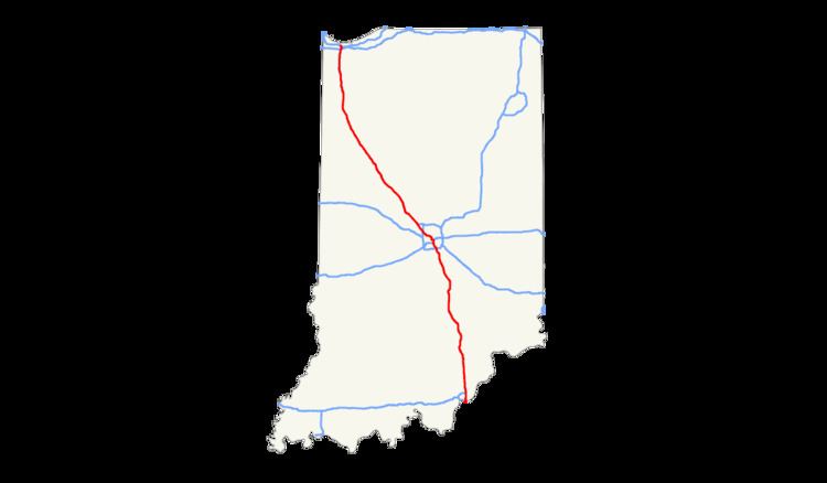 | ||
In the U.S. state of Indiana, Interstate 65 (I-65) traverses from the south-southeastern Falls City area bordering Louisville, Kentucky through the centrally located capital city of Indianapolis, to the northwestern Calumet Region of the Hoosier State which is part of the Chicago, Illinois metro area. The Indiana portion of I-65 begins in Jeffersonville after crossing the Ohio River and travels mainly north, passing just west of Columbus prior to reaching the Indianapolis metro area. Upon reaching Indianapolis, the route alignment of I-65 begins to run more to the northwest and subsequently passes Lafayette on that city's east and north sides. Northwest of there, in west-central Jasper County, the route again curves more northward as it approaches the Calumet Region. Shortly after passing a major junction with I-80 and I-94, I-65 reaches its northern national terminus in Gary at I-90 which is carried on the Indiana East-West Toll Road. Interstate 65 covers 261.27 miles (420.47 km) in the state of Indiana. This is one of the principal interstate highways that cross the state, and, more specifically, intersect at the city of Indianapolis, that has given the state the nickname of "Crossroads of America".
Contents
Route description
Interstate 65 enters the state northbound at Jeffersonville (across the Ohio River from Louisville, Kentucky) on the Abraham Lincoln Bridge; traffic exiting the state travels on the John F. Kennedy Memorial Bridge. I-65 travels past Clark State Forest before reaching Seymour to the north. I-65 intersects with US 50 providing access to Seymour to the west. US 31 runs parallel to the interstate until it reaches Indianapolis. North of Seymour, I-65 passes through Columbus. Just north of Columbus, I-65 runs near Camp Atterbury, an Indiana National Guard training base. The interstate continues north into Indianapolis.
Interstate 65 crosses the I-465 loop before reaching Indianapolis. The section of Interstate 65 in downtown Indianapolis overlaps Interstate 70. The junctions are often referred to as the "North Split" and the "South Split", forming a section of interstate locally known as the "Inner Loop" or "Spaghetti Bowl" due to the visual complexity of the overlapping freeways. In 1999, the 25-mile (40 km) segment of Interstate 65 between the two Interstate 465 interchanges was renamed the Kenneth "Babyface" Edmonds Highway. At mile marker 116, I-65 passes Crown Hill Cemetery, burial site and memorial of President Benjamin Harrison. I-65 leaves the I-465 loop on the northwest side of Indianapolis. The highway travels past Eagle Creek Park and it then passes the terminus of I-865 and picks up US 52.
The segment of Interstate 65 north of Indianapolis heads in the direction of Chicago, Illinois. US 52 runs concurrent until the north side of Lebanon. From this point US 52 runs parallel to I-65. At about the halfway point to the end of I-65 and Indianapolis, I-65 passes through Lafayette. I-65 crosses the Wabash River in Lafayette and passes next to Prophetstown State Park. North of Lafayette, I-65 passes through the open flatlands of northwest Indiana. Protruding from the fields are some of the hundreds of wind turbines of the Benton County Wind Farm and Fowler Ridge Wind Farm.
At approximately mile 199.4 is the time zone boundary between Central Time (Jasper County) and Eastern Time (White County). As with all time zone changes on highways maintained by the Indiana Department of Transportation, this change in time zone is not marked with any roadside signage.
Upon crossing into Lake County, over the Kankakee River, the highway is known as the Casimir Pulaski Memorial Highway. It is known as this from that point to its northern terminus. The northern terminus of Interstate 65 is only 1⁄8 mile (0.20 km) north of Interstate 90 (Indiana Toll Road).
Initial construction
Like all Interstate highways in Indiana, I-65 was constructed in segments which when all were complete, made up the route we know today. There were six segments in the southern portion of the state between the Kentucky border and the south leg of I-465 in Indianapolis, nine within the I-465 loop in Indy, and eleven more that made up the northern portion connecting the northwest side of Indianapolis to the Indiana Toll Road (I-90) in Gary.
The first section of I-65 to be completed in Indiana was a 13.39-mile (21.55 km) stretch between a temporary connection with US 52 near Royalton in Boone County (just south of the present-day interchange with I-865) and the US 52 junction northwest of Lebanon, which opened in December 1960. The initial southern Indiana portion, running 45.71 miles (73.56 km) between then-US 31E (now US 31) in Clarksville and US 50 east of Seymour, saw its first traffic in November 1961. The final of the 17 segments of I-65 outside of I-465, 23.09 miles (37.16 km) from SR 252 near Edinburgh to Southport Road on Indy's far south side, opened on June 30, 1972.
Unlike for most of portions of I-70 within the I-465 beltway, several inner sections of I-65 were built throughout the overall project lifespan. But the final three segments from the south side through the heart of the city, including the common portion of I-65 and I-70 (east leg of the "Inner Belt"), were not finished and opened to traffic until around 1974.
Subsequent improvements
Prior to 2004, the interchange from the Indiana Toll Road to southbound I-65 required making a physical left turn onto I-65 via a traffic signal; traffic from northbound I-65 to I-90 bypassed the traffic signal via an isolated right-turn lane. This deficiency has since been corrected by a grade-separation.
As part of the Operation Indy Commute project, INDOT began work in 2013 to widen I-65 on both northbound and southbound mainlines from exit 103 at Southport Road northward to the southern junction with I-465 (exit 106), adding auxiliary lanes in this section to improve merging of traffic entering southbound I-65 from I-465 and entering northbound I-65 from westbound Southport Road. To reduce congestion on I-65 South from I-465 West, the loop ramp from westbound I-465 was replaced by a flyover ramp to southbound I-65. The eastbound I-465 exit to southbound I-65 South was also expanded for improved merging with traffic from the new west-to-south flyover. Most of this work was completed in late 2014.
Auxiliary routes
I-65 has three auxiliary routes in Indiana: