
Founded April 30, 1813 Website www.warrickcounty.gov Population 61,049 (2013) | Area 1,013 km² | |
 | ||
Colleges and Universities Trinity College and Seminary Points of interest | ||
Warrick county indiana land iauction
Warrick County is a county located in the U.S. state of Indiana. As of 2010, the population was 59,689. The county seat is Boonville. It was organized in 1813 and was named for Captain Jacob Warrick, an Indiana militia company commander killed in the Battle of Tippecanoe in 1811. It is one of the ten fastest-growing counties in Indiana.
Contents
- Warrick county indiana land iauction
- Map of Warrick County IN USA
- History
- Geography
- Adjacent Counties
- Cities and towns
- Climate and weather
- Government
- Demographics
- Education
- References
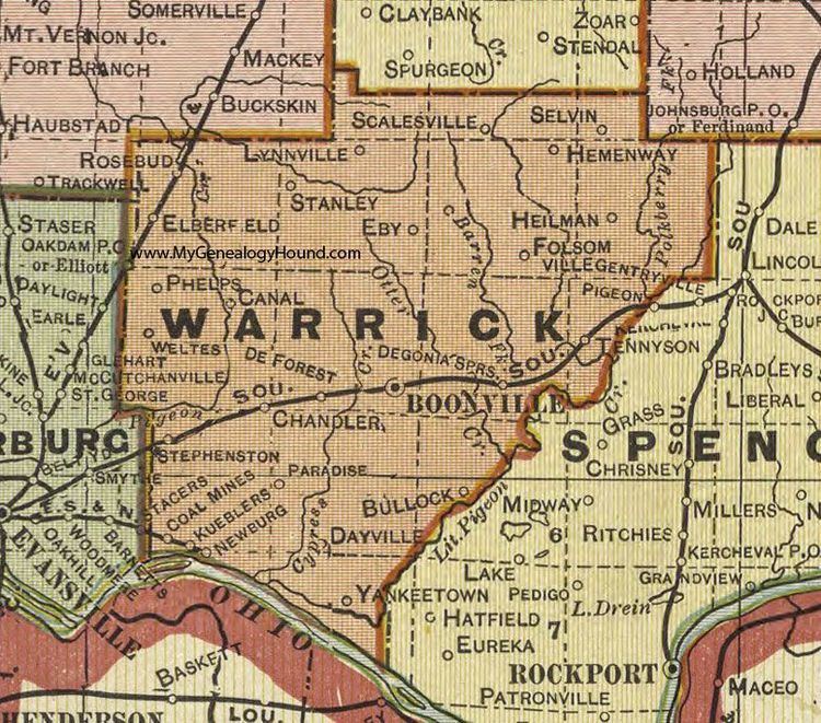
Map of Warrick County, IN, USA
Warrick County is the eastern part of the Evansville, IN–KY Metropolitan Statistical Area.
History
Warrick County was formed by statute, March 9, 1813, effective April 1, 1813. Knox County was affected by this formation. Warrick County boundaries began at the mouth of the Wabash River; then up the Wabash River with the meanders thereof to the mouth of the White River; then up the White River with the meanders thereof to the Forks of the White River; then up White River East Fork to where the line between Sections 20 and 29, Township 1 North, Range 4 West, strikes the same; then with that line to the then Gibson County line; then with that line dividing Gibson and Knox Counties to the Ohio River; then down the Ohio River, to the place of beginning. The same was divided into two separate and distinct counties, by a line beginning on the Wabash River, known as Rector's Base Line (was surveyed by William Rector on the line between Townships 4 South and 5 South, from New Harmony, Posey County, and Alton, Crawford County, Indiana), and with that line east until it intersects the then Gibson County line and that tract of land falling within the southern division thereof was Warrick County.
Geography
According to the 2010 census, the county has a total area of 391.05 square miles (1,012.8 km2), of which 384.82 square miles (996.7 km2) (or 98.41%) is land and 6.24 square miles (16.2 km2) (or 1.60%) is water.
Adjacent Counties
Cities and towns
Climate and weather
In recent years, average temperatures in Boonville have ranged from a low of 23 °F (−5 °C) in January to a high of 89 °F (32 °C) in July, although a record low of −24 °F (−31 °C) was recorded in January 1994 and a record high of 101 °F (38 °C) was recorded in July 1999. Average monthly precipitation ranged from 2.71 inches (69 mm) in September to 5.08 inches (129 mm) in March.
Government
The county government is a constitutional body, and is granted specific powers by the Constitution of Indiana, and by the Indiana Code.
County Council: The county council is the legislative branch of the county government and controls all the spending and revenue collection in the county. Four representatives are elected from county districts, and three are elected as "at-large" members. The council members serve four-year terms. They are responsible for setting salaries, the annual budget, and special spending. The council also has limited authority to impose local taxes, in the form of an income and property tax that is subject to state level approval, excise taxes, and service taxes.
Board of Commissioners: The executive body of the county is made of a board of commissioners. The commissioners are elected county-wide, in staggered terms, and each serves a four-year term. One of the commissioners, typically the most senior, serves as president. The commissioners are charged with executing the acts legislated by the council, collecting revenue, and managing the day-to-day functions of the county government.
Court: The county maintains a small claims court that can handle some civil cases. The judge on the court is elected to a term of four years and must be a member of the Indiana Bar Association. The judge is assisted by a constable who is also elected to a four-year term. In some cases, court decisions can be appealed to the state level circuit court.
County Officials: The county has several other elected offices, including sheriff, coroner, auditor, treasurer, recorder, surveyor, assessor, and circuit court clerk. Each of these elected officers serves a term of four years and oversees a different part of county government. Members elected to county government positions are required to declare party affiliations and to be residents of the county.
Demographics
As of the 2010 United States Census, there were 59,689 people, 22,505 households, and 17,009 families residing in the county. The population density was 155.1 inhabitants per square mile (59.9/km2). There were 24,203 housing units at an average density of 62.9 per square mile (24.3/km2). The racial makeup of the county was 95.0% white, 1.6% Asian, 1.3% black or African American, 0.2% American Indian, 0.5% from other races, and 1.3% from two or more races. Those of Hispanic or Latino origin made up 1.6% of the population. In terms of ancestry, 35.3% were German, 15.4% were Irish, 13.4% were American, and 12.5% were English.
Of the 22,505 households, 36.4% had children under the age of 18 living with them, 62.7% were married couples living together, 9.2% had a female householder with no husband present, 24.4% were non-families, and 20.7% of all households were made up of individuals. The average household size was 2.62 and the average family size was 3.02. The median age was 39.7 years.
The median income for a household in the county was $47,697 and the median income for a family was $73,583. Males had a median income of $51,961 versus $32,885 for females. The per capita income for the county was $29,737. About 3.9% of families and 6.1% of the population were below the poverty line, including 6.4% of those under age 18 and 6.3% of those age 65 or over.
Education
The county's school corporation is Warrick County School Corporation which consists of 16 schools (two high schools, one senior/junior high, three middle schools, ten elementary schools, and one alternative school). In the Fall of 2009, the corporation transitioned its stand-alone Junior High schools in the Boonville and Castle High School Districts from the Junior High system to the Middle School system, with the addition of one middle school (Castle South Middle School) in the Castle District. Castle Junior High was renamed Castle North Middle School. Warrick County's three middle schools are composed of grades six through eight.