
Length 84.96 km | ||
 | ||
Existed: 1959 (completed 1970) – present | ||
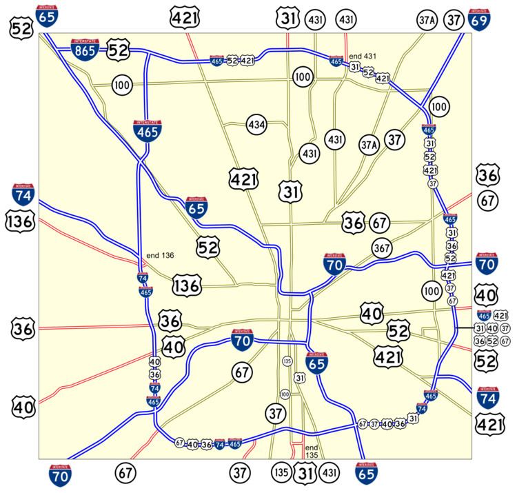
Interstate 465 (I-465), also known as the USS Indianapolis Memorial Highway, is the beltway circling Indianapolis, Indiana, United States. It is roughly rectangular in shape and has a perimeter of approximately 53 miles (85 km). It lies almost completely within the boundaries of Marion County, except for two short sections on the north leg in Boone and Hamilton Counties. It crosses I-65, I-69, I-70 and I-74, and provides additional access to I-65 via I-865.
Contents
- Map of I 465 Indianapolis IN USA
- Route description
- Planning and alignment selection
- Initial construction 195970
- Subsequent improvements and changes
- Memorial designation
- Future
- References
Map of I-465, Indianapolis, IN, USA
Route description
Except for I-65 and I-70, no numbered highways run through downtown Indianapolis. All highways that continue from one side to the other are routed around the city, concurrent with I-465:
Once the extension currently under construction is completed, Interstate 69 will be routed from I-465's intersection with the new Interstate around the south and eastern sections to its current intersection with I-69, joining the two sections.
The approximately one-mile section between exits 46 and 47 upon completion of the Interstate 69 extension will carry nine routes — I-465, I-69, US 31, US 36, US 40, US 52, US 421, SR 37 and SR 67. In most cases, markers other than I-74's are not posted along I-465 itself; rather, signs on the entrance ramps direct traffic traveling a particular route to follow I-465 to a specific exit to continue on that route.
Planning and alignment selection
A beltway for Indianapolis was part of the original plan of the Interstate System in 1955. The general alignment was to be either on or adjacent to the now-defunct SR 100, which by then had only two completed legs—on the north side, along 86th Street to the west of the White River and 82nd Street east of the river, and on the east side along Shadeland Avenue. On the city's west side, an alignment corridor paralleling High School Road was preferred, and on the south side, one between Hanna Avenue and Thompson Road was proposed. Development along 86th Street made its use unfeasible for I-465, so a 91st Street alignment was initially proposed. This proved to be controversial, and caused many delays in final alignment selection for the North Leg, postponing its construction by several years.
Initial construction (1959–70)
Like all Interstate highways in Indiana, the I-465 beltway was constructed in segments which when all were complete, made up the route we know today (with the exception of the 4.72 miles (7.60 km) renamed as I-865 in 2002). There were 16 segments along the original semi-circumferential selected alignment between I-65 in Boone County at exit 129 and that same highway six miles to the south at exit 123 in Marion County. Indiana highway officials recognized the value of having the route be a full circumferential, so using non-Interstate federal funding and employing a temporary designation of SR 100 they planned a separate 17th segment northward between I-65 at its exit 123 and the north leg of I-465 in Boone County. By the time that added section was completed in 1970, Indiana had obtained federal approval to sign it as I-465 as well, resulting in the creation of the dogleg part of I-465 outside of the loop (now I-865 as noted above).
State highway officials concentrated on building the west and south legs of I-465 early in the overall project, since they were the missing portions of the SR 100 concept. Construction began in 1959, and the first section of the I-465 beltway to be completed was the portion on the west leg between I-65 near Eagle Creek Park and I-74/US 136 in Speedway, which opened to traffic on September 26, 1961, simultaneously with the adjacent section of I-65 northwest from there running 1.48 miles (2.38 km) to 71st Street. By July 18, 1962, all four segments of the original west leg were open between Kentucky Avenue (SR 67) and I-65, but the interchange with I-70 in that stretch was not completed until much later that decade when the segment of that route from I-465 west to SR 43 opened in 1968.
The south side sections were next be completed, with three opening in the second half of 1963 and two more on October 15, 1964. This completed both the south leg and the first segment of the east leg, connecting to the southern SR 100 (Shadeland Avenue) extension from Washington Street (US 40) at a point just north of the Raymond Street grade separation. With these sections open, the full length of I-74's concurrency over I-465 was now available for motorists. Also the south leg's junction with I-65 was completed, but that freeway was only open to the north (and then only 1.18 miles (1.90 km) to Keystone Avenue) until early 1971.
With Shadeland Avenue (then SR 100) now connected to a full southern and western bypass of Indy, the pressure was off of the Indiana State Highway Commission and work on I-465's east leg slowed, delaying the opening of the next segment over three years. In January 1968 two sections of the east leg, between Pendleton Pike (US 36/SR 67) and the SR 100 junction near Raymond Street, were completed and opened a day apart. This allowed through traffic from both US 36 and SR 67 to bypass the increasingly congested SR 100 by using the new sections of I-465 instead. The interchange with I-70 in this newly opened section was not yet complete and its ramps did not open until the mainline of that route did later that year on December 2, 1968, between SR 100/Shadeland Avenue and SR 9 near Greenfield. On October 23, 1968, the section of I-465 between Pendleton Pike and 56th Street at Shadeland Avenue was finished and opened to traffic, completing the east leg's eastern bypass of SR 100.
With its alignment controversies now settled and in the read-view mirror, the north leg of I-465 began to take shape toward the end of the 1960s. The section between Michigan Road (US 421) and Meridian Street (US 31) was the first on this side of town to see traffic, on October 20, 1968. A year to the day later, the next segment from US 31 to Keystone Avenue (then SR 431) was opened to motorists. The next month, in November 1969, the north extension of the west leg was completed and signed as I-465 (though it was considered to be "added mileage" by the Federal Highway Administration (FHWA) since it was built to Interstate standards using non-Interstate funds by Indiana), but this section only opened between I-65 and 86th Street, as the segment of the north leg to which it reached was not yet complete. That occurred on August 18, 1970, when the western end of the north leg (including the infamous dogleg mileage) between I-65 near Royalton and Michigan Road (US 421) was finished and opened to traffic. At that time the final connection on the north extension of the west leg to 86th Street was also opened, leaving only one remaining gap in the entire I-465 route.
The final section of I-465 to be built was the portion joining the north and east legs, between Keystone Avenue (then SR 431) and 56th Street at Shadeland Avenue (then SR 100). This stretch opened to traffic on October 5, 1970, and marked the final completion of the I-465 beltway around Indianapolis. The exact transition point between the north and east legs remains a point of argument, with most believing it is at the interchange with I-69/SR 37 and Binford Boulevard (former SR 37), but some maintaining it is a little further south, at either the 75th Street or the 71st Street grade separations.
Subsequent improvements and changes
In the early 2000s, the north extension of I-465's west leg between I-65 and I-865 was rebuilt to widen and update the freeway located along the western edge of the Park 100 commercial and industrial development. This section was becoming obsolete due to continued growth of that complex as well as that of other nearby residential and commercial projects in Pike Township. Both interchanges along this stretch, at 71st Street (exit 21) and 86th Street (exit 23), were totally rebuilt and had loop ramps added for west-to-south movements. Also, an additional northbound exit ramp to 73rd Street was built. On the mainline, a fourth travel lane plus dual auxiliary lanes between these two interchanges were added in this section for each travel direction.
INDOT completed an $800 million project called Accelerate 465 to refurbish and reconfigure the original west leg of the loop between July 2007 and December 2012. This project completely rebuilt and added new travel lanes, added auxiliary lanes, rebuilt many grade separations, and reconfigured nearly all of the interchanges along I-465 from just north of the Kentucky Avenue (SR 67 south) interchange to the 56th Street partial interchange. The junction with I-74 and Crawfordsville Road (US 136 west) was reconfigured to allow direct access between I-465 and US 136 for the first time. Interlaced into that design is a full directional connection for I-74, which replaced the former cloverleaf interchange and removed its original stub connector east of I-465 to the intersection of Crawfordsville Road and High School Road in Speedway.
In April 2002, INDOT announced the redesignation of the dogleg portion of I-465 as I-865. This change eliminated the three-way intersection of I-465 where the north extension of the west leg meets the original north leg (at exit 25).
In 2007, another undertaking was launched by INDOT to modernize the entire northeastern portion of I-465. All three interchanges along the freeway in this stretch—Keystone Avenue (exit 33), Allisonville Road (exit 35) and I-69/Binford Boulevard (exit 37)—were to be modified and rebuilt. As this project progressed, financial constraints prompted INDOT to scale back its scope. The canceled interchange rebuilds at I-465 and 82nd Street are not scheduled for construction until at least 2020 under a separate project announced in 2015. The scaled-back project concluded by the end of 2012. The beltway's mainline was reconstructed with additional travel and auxiliary lanes being added in two separate segments—from east of Meridian Street to Allisonville Road, and from a point at the southeast end of the I-69/Binford interchange southward to Fall Creek. The Keystone Avenue parclo interchange was reconfigured to allow free-flowing access. At Allisonville Road, the interchange was converted into a more efficient single-point urban interchange configuration. Finally, though the interchange itself was not rebuilt, the I-69/Binford Boulevard junction had two ramps slightly modified.
As part of the major project to upgrade 13 miles (21 km) of US 31 in Hamilton County to a full Interstate-standard freeway, the I-465 north leg interchange at Meridian Street (exit 31) was reconfigured between October 2013 and December 2015 (with some additional work continuing until November 22, 2016) to the present partial directional (system interchange) design which allows for free-flow movements to or from the new US 31 freeway to the north.
As part of its Operation Indy Commute project, INDOT began work in 2013 to widen I-65 on both its northbound and southbound mainlines from exit 103 at Southport Road northward to the junction with I-465's south leg, which would also be modified. To reduce congestion at and near that interchange, the loop ramp from westbound I-465 to southbound I-65 was replaced by a flyover ramp. The eastbound I-465 exit to southbound I-65 was also expanded for smoother merging with the new west-to-south flyover. In addition, grade separations over I-465 were replaced on Sherman Drive and Carson Avenue to allow for longer and wider approaches to this busy junction. Most of this work was completed in late 2014.
Memorial designation
In 2002, Indianapolis native David Letterman's late-night talk show sidekick and band leader Paul Shaffer was honored by having a street in Thunder Bay, Ontario, named for him. This led Letterman to ask (on his program) why he couldn't have his own eponymous road, and he suggested I-465 be named the David Letterman Expressway (sic). His fans took the idea seriously, especially in the Indianapolis area where highway signs promoting the idea were displayed. Advertisers and a few traffic reports started to refer to I-465 as the "DLX", or later the "David Letterman Bypass", a reference to his quintuple heart bypass surgery in January 2000. Letterman even telephoned the Mayor of Indianapolis, Bart Peterson to make his case, but eventually the idea went nowhere.
In 2011 the Indiana General Assembly passed a resolution officially designating I-465 as "USS Indianapolis Memorial Highway" in "the memory of the brave sailors who lost their lives" when USS Indianapolis was sunk in the Pacific during World War II. Signs touting this designation have since been erected sporadically around the loop, but the highway is still referred to nearly exclusively as "I-465" or simply "465" by most locals.
Future
Between 2017 and 2020, segment of independent utility (SIU) 2 for Interstate 69 will be signed to run concurrently with I-465 around Indianapolis from a new exit 5 for I-69 and SR 37 south counterclockwise (east) along the south leg of I-465 and then north on the east leg to exit 37..
Remaining sections of the I-465 beltway that are still awaiting reconstruction or widening projects include the west leg junction with I-65, the north leg between I-865 and US 31 North/Meridian Street, the north leg section from Allisonville Road to the I-69/Binford Boulevard interchange and several portions along the south leg.