
Country United States County Owen Time zone Eastern (EST) (UTC-5) Elevation 171 m Zip code 47460 Local time Wednesday 8:14 AM | State Indiana FIPS code 18-71972 Area 3.26 km² Population 2,317 (2013) Area code 812 | |
 | ||
Weather 9°C, Wind E at 16 km/h, 80% Humidity | ||
Spencer is a town in Washington Township, Owen County, Indiana, United States. The population was 2,217 at the 2010 census. It is the county seat of Owen County.
Contents
Map of Spencer, IN 47460, USA
Spencer is part of the Bloomington, Indiana Metropolitan Statistical Area.
History
Spencer was platted in 1820, and named for Captain Spier Spencer, who fell at the Battle of Tippecanoe. A post office has been in operation at Spencer since 1821.
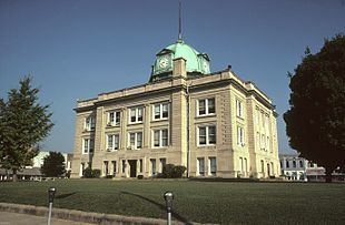
The Allison-Robinson House, David Enoch Beem House, Owen County Courthouse, Spencer Public Library, and Spencer Town Hall and Fire Station are listed on the National Register of Historic Places.
Geography
According to the 2010 census, Spencer has a total area of 1.26 square miles (3.26 km2), all land.
Climate
The climate in this area is characterized by hot, humid summers and generally mild to cool winters. According to the Köppen Climate Classification system, Spencer has a humid subtropical climate, abbreviated "Cfa" on climate maps.
2010 census
As of the census of 2010, there were 2,217 people, 1,008 households, and 554 families residing in the town. The population density was 1,759.5 inhabitants per square mile (679.3/km2). There were 1,123 housing units at an average density of 891.3 per square mile (344.1/km2). The racial makeup of the town was 98.1% White, 0.1% African American, 0.2% Native American, 0.5% Asian, 0.2% from other races, and 0.9% from two or more races. Hispanic or Latino of any race were 2.1% of the population.
There were 1,008 households of which 24.6% had children under the age of 18 living with them, 38.4% were married couples living together, 12.8% had a female householder with no husband present, 3.8% had a male householder with no wife present, and 45.0% were non-families. 40.1% of all households were made up of individuals and 18.4% had someone living alone who was 65 years of age or older. The average household size was 2.12 and the average family size was 2.81.
The median age in the town was 41.8 years. 20.1% of residents were under the age of 18; 9.4% were between the ages of 18 and 24; 24.2% were from 25 to 44; 26.3% were from 45 to 64; and 19.8% were 65 years of age or older. The gender makeup of the town was 47.2% male and 52.8% female.
2000 census
As of the census of 2000, there were 2,508 people, 1,090 households, and 659 families residing in the town. The population density was 1,984.6 people per square mile (768.5/km²). There were 1,193 housing units at an average density of 944.0 per square mile (365.6/km²). The racial makeup of the town was 98.52% White, 0.20% African American, 0.40% Asian, 0.24% from other races, and 0.64% from two or more races. Hispanic or Latino of any race were 0.60% of the population.
There were 1,090 households out of which 27.2% had children under the age of 18 living with them, 45.1% were married couples living together, 12.8% had a female householder with no husband present, and 39.5% were non-families. 35.0% of all households were made up of individuals and 18.5% had someone living alone who was 65 years of age or older. The average household size was 2.23 and the average family size was 2.88.
In the town, the population was spread out with 23.0% under the age of 18, 10.1% from 18 to 24, 26.7% from 25 to 44, 20.3% from 45 to 64, and 20.0% who were 65 years of age or older. The median age was 39 years. For every 100 females there were 83.2 males. For every 100 females age 18 and over, there were 81.9 males.
The median income for a household in the town was $28,664, and the median income for a family was $36,921. Males had a median income of $29,679 versus $21,531 for females. The per capita income for the town was $15,843. About 8.4% of families and 9.5% of the population were below the poverty line, including 13.2% of those under age 18 and 8.8% of those age 65 or over.
General
Spencer, Indiana, was named after a soldier, George Spencer, who fought in the Battle of Tippecanoe on 7 November 1811, and died on the battlefield after being shot three times. John Tipton, a Tippecanoe veteran and a commander of the Indiana Rangers, was given the honor of naming the town on 12 February 1820, as he writes in his journal: "the Citizens then gave me the honor of naming the new Town which I Called Spencer after my friend George Spencer who fell in the Battle of Tippicannoe."
The town of Spencer was laid out in 1820 and the first auction for lots took place. The first court house was built of logs and replaced in 1825 with a brick courthouse. That courthouse stood until 1910 when the current courthouse was constructed to replace it. In 1890 a steam driven dynamo was installed in Spencer for carbon arc street lights. Spencer also recently passed Indianapolis as the town with the most married couples with children per capita in the state.
Owen Valley Community High School (OVHS) is located in Spencer with 980 students and more than 100 faculty members. Built in 1971, OVHS is the result of a consolidation of several smaller schools located within Owen County. Owen Valley's mascot is the Patriot, and the school's colors are red, white and blue. The school's yearbook is the Triad, Tri- meaning the three schools that were merged to make Owen Valley High School.