
Length: 171.54 mi (276.07 km) | Existed: 1960 – present | |
 | ||
In the U.S. state of Indiana, Interstate 74 (I-74) traverses central parts of the state from west to east. It connects Champaign, Illinois with Indianapolis in the center of the state, and Indianapolis with Cincinnati, Ohio . Interstate 74 covers 171.54 miles (276.07 km) across Indiana, a portion of which is concurrently routed through Indianapolis along the southern and western legs of Interstate 465.
Contents
Route description
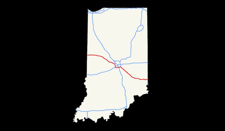
The Indiana portion of Interstate 74 begins on the Illinois border near Danville, Illinois and travels east. Shortly into Indiana, the interstate crosses the Wabash River near Covington. I-74 continues east where it passes over US 136 and intersects US 41 at Veedersburg about 15 miles east of the Illinois border. 19 miles later, the interstate intersects US 231 providing access to Crawfordsville to the south. I-74 runs nearly parallel to US 136 from the Illinois border until US 136 terminates at Interstate 465.
Once I-74 reaches Indianapolis it continues south, overlapping I-465. I-74 runs concurrent with I-465 on I-465's western and southern segments. (The exits of this concurrency are numbered as if it were part of I-465 only.) It also overlaps with US 31, US 36, US 40, US 52, and several state highways, for varying lengths of its route around Indianapolis. I-74 also crosses the White River and passes by the Indianapolis International Airport on the southwest side of Indianapolis. Once I-74 reaches the southeast side of Indianapolis it diverges from I-465 and continues to the southeast. At this intersection, I-74 picks up US 421 from where it will run concurrent.
Outside of the Indianapolis area, I-74 continues southeast and runs past Shelbyville. Near the halfway point between Indianapolis and the Ohio border, I-74 runs through Greensburg. US-421 diverges and runs south through Greensburg. Continuing on east, I-74 runs parallel to State Route 46. Just west of the Ohio border, I-74 crosses the Whitewater River. It also intersects with and begins to overlap with US 52. The two then continue and cross into Ohio at Harrison.
Initial Construction
Like all Interstate highways in Indiana, I-74 was constructed in segments which, when all were complete, make up the current route. There were six segments in the western portion of the route between the Illinois state line and I-465 in Speedway, and six more in the eastern portion connecting I-465 near Beech Grove to the Ohio state line. The concurrent portions around Indianapolis on I-465, consisting of seven separate sections along the west and south legs of that beltway, became operational between December 21, 1961 and October 15, 1964. The eastern segments connecting Indianapolis and Cincinnati were also given a relatively high priority and were all completed and open by October 30, 1964.
The first section of Interstate 74 to be built in Indiana was the portion from the Illinois state line east for just under 8 miles (13 km) to the Covington exit just beyond the Wabash River, which opened to traffic in December of 1960. The final 13.5-mile (21.7 km) segment, located in Fountain and Montgomery counties and also along the western portion of the route, was finished and opened on August 31, 1967, marking the full completion of I-74 in the state.