
Country United States County Steuben Time zone EST (UTC-5) Elevation 322 m Zip code 46737 Area code 260 | State Indiana FIPS code 18-25882 Local time Friday 3:21 AM Population 2,149 (2013) | |
 | ||
Weather -5°C, Wind NW at 2 km/h, 76% Humidity Area 5.776 km² (5.75 km² Land / 3 ha Water) | ||
Fremont is a town in Fremont Township, Steuben County, in the U.S. state of Indiana. The population was 2,138 at the 2010 census.
Contents
- Map of Fremont IN 46737 USA
- History
- Geography
- 2010 census
- 2000 census
- Sites of interest
- Schools
- Manufacturing
- Downtown Revitalization
- References
Map of Fremont, IN 46737, USA
History
Fremont was first settled in 1834 under the name Willow Prairie. It became the Village of Brockville when it was platted in 1837. In 1848, it was renamed to honor John C. Frémont, "the Great Pathfinder", in part because there was already a Brockville in Indiana.
A post office was established under the name Brockville in 1837, and was renamed to Fremont in 1848. The post office is currently in operation.
In 1914, the first hospital in Steuben County was opened in Fremont by Dr. Wade.
Geography
Fremont is located at 41°43′52″N 84°55′57″W, four miles east of the interchange between Interstate 69 and the Indiana Toll Road (Interstate 80/90) on State Road 120.
According to the 2010 census, Fremont has a total area of 2.22 square miles (5.75 km2), of which 2.21 square miles (5.72 km2) (or 99.55%) is land and 0.01 square miles (0.03 km2) (or 0.45%) is water.
As an oddity, someone traveling due east from Fremont crosses into Michigan—not into Ohio. This is due to the early 19th century Ohio-Michigan boundary dispute over Toledo (q.v. Toledo War for details).
2010 census
As of the census of 2010, there were 2,138 people, 815 households, and 561 families residing in the town. The population density was 963.1 inhabitants per square mile (371.9/km2). There were 878 housing units at an average density of 395.5 per square mile (152.7/km2). The racial makeup of the town was 98.6% White, 0.2% African American, 0.2% Native American, 0.3% Asian, 0.4% from other races, and 0.3% from two or more races. Hispanic or Latino of any race were 1.8% of the population.
There were 815 households of which 40.4% had children under the age of 18 living with them, 46.1% were married couples living together, 15.3% had a female householder with no husband present, 7.4% had a male householder with no wife present, and 31.2% were non-families. 23.9% of all households were made up of individuals and 9.5% had someone living alone who was 65 years of age or older. The average household size was 2.62 and the average family size was 3.08.
The median age in the town was 33.1 years. 29.1% of residents were under the age of 18; 9.8% were between the ages of 18 and 24; 28.8% were from 25 to 44; 21.9% were from 45 to 64; and 10.5% were 65 years of age or older. The gender makeup of the town was 48.4% male and 51.6% female.
2000 census
As of the census of 2000, there were 1,696 people, 640 households, and 455 families residing in the town. The population density was 761.9 people per square mile (293.6/km²). There were 679 housing units at an average density of 305.0 per square mile (117.6/km²). The racial makeup of the town was 98.11% White, 0.18% African American, 0.29% Native American, 0.06% Asian, 0.47% from other races, and 0.88% from two or more races. Hispanic or Latino of any race were 1.95% of the population.
There were 640 households out of which 43.4% had children under the age of 18 living with them, 50.8% were married couples living together, 15.2% had a female householder with no husband present, and 28.9% were non-families. 26.1% of all households were made up of individuals and 11.7% had someone living alone who was 65 years of age or older. The average household size was 2.65 and the average family size was 3.18.
In the town, the population was spread out with 33.1% under the age of 18, 8.1% from 18 to 24, 29.7% from 25 to 44, 18.3% from 45 to 64, and 10.8% who were 65 years of age or older. The median age was 32 years. For every 100 females there were 83.0 males. For every 100 females age 18 and over, there were 80.4 males.
The median income for a household in the town was $38,462, and the median income for a family was $42,446. Males had a median income of $31,333 versus $22,260 for females. The per capita income for the town was $16,067. About 5.7% of families and 7.3% of the population were below the poverty line, including 6.6% of those under age 18 and 10.1% of those age 65 or over.
Sites of interest
The following are National Register of Historic Places sites in or near Fremont:
Fremont and the surrounding area enjoys several facilities and activities throughout the year:
Schools
Fremont Community Schools oversees three schools in its district: Fremont High School, Fremont Middle School and Fremont Elementary School. Enrollment in each building ranges between 350 and 400 students annually. Several extracurricular athletic programs are available at the middle and high school levels, including football, basketball, volleyball, wrestling, cross country, track and golf. FHS also fields teams for tennis, baseball and softball.
According to the State of Indiana Department of Education, Fremont Community Schools has been awarded an "A" grade designation for their Exemplary Student Performance for the 2011-2012 School Year.
Manufacturing
Fremont is home to several manufacturing facilities, including Cold Heading, Swager Communications, New Horizons Baking Company, Health Equipment Mfg., Inc. and Dexter Axle. Among others is Cardinal IG, which came to Fremont in March 1998. Cardinal IG, manufacturers of glass products, have been recognized as a green company, recycling virtually all of the plastic, paper and cardboard used in manufacturing processes.
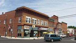
Downtown Revitalization
In December 2010, Fremont was awarded $500,000 from the State of Indiana for its downtown revitalization project. According to the Town of Fremont website, the plan included improvements for pedestrian traffic, new street lighting and signage options, and reverse angle parking along Toledo Street for two blocks between Tolford and Pleasant Streets. Construction began in September 2011 and was finished roughly 90 days later.