
 | ||
A phytochorion, in phytogeography, is a geographic area with a relatively uniform composition of plant species. Adjacent phytochoria do not usually have a sharp boundary, but rather a soft one, a transitional area in which many species from both regions overlap. The region of overlap is called a vegetation tension zone.
Contents
- Explanation
- Early schemes
- Good 1947 regionalization
- Takhtajan 1978 1986 regionalization
- I Circumboreal region
- II Eastern Asiatic region
- III North American Atlantic Region
- IV Rocky Mountain Floristic Region
- V Macaronesian region
- VI Mediterranean region
- VII Saharo Arabian region
- VIII Irano Turanian region
- IX Madrean region
- X Guineo Congolian region
- XI Usambara Zululand region
- XII Sudano Zambezian region
- XIII Karoo Namib region
- XIV St Helena and Ascension region
- XV Madagascan region
- XVI Indian region
- XVII Indochinese region
- XVIII Malesian region
- XIX Fijian region
- XX Polynesian region
- XXI Hawaiian region
- XXII Neocaledonian region
- XXIII Caribbean region
- XXIV region of the Guayana Highlands
- XXV Amazon region
- XXVI Brazilian region
- XXVII Andean region
- XXVIII Cape region
- XXIX Northeast Australian region
- XXX Southwest Australian region
- XXXI Central Australian or Eremaean region
- XXXII Fernandezian region
- XXXIII Chile Patagonian region
- XXXIV region of the South Subantarctic Islands
- XXXV Neozeylandic region
- References
In traditional schemes, areas in phytogeography are classified hierarchically, according to the presence of endemic families, genera or species, e.g., in floral (or floristic, phytogeographic) zones and regions, or also in kingdoms, regions and provinces, sometimes including the categories empire and domain. However, some authors prefer not to rank areas, referring to them simply as "areas", "regions" (in a non hierarchical sense) or "phytochoria".
Systems used to classify vegetation can be divided in two major groups: those that use physiognomic-environmental parameters and characteristics and those that are based on floristic (i.e. shared genera and species) relationships. Phytochoria are defined by their plant taxonomic composition, while other schemes of regionalization (e.g., vegetation type, physiognomy, plant formations, biomes) may variably take in account, according to the author, the apparent characteristics of a community (the dominant life-form), environment characteristics, the fauna associated, anthropic factors or political-conservationist issues.
Explanation
Several systems of classifying geographic areas where plants grow have been devised. Most systems are organized hierarchically, with the largest units subdivided into smaller geographic areas, which are made up of smaller floristic communities, and so on. Phytochoria are defined as areas possessing a large number of endemic taxons. Floristic kingdoms are characterized by a high degree of family endemism, floristic regions by a high degree of generic endemism, and floristic provinces by a high degree of species endemism. Systems of phytochoria have both significant similarities and differences with zoogeographic provinces, which follow the composition of mammal families, and with biogeographical provinces or terrestrial ecoregions, which take into account both plant and animal species.
The term "phytochorion" (Werger & van Gils, 1976) is especially associated with the classifications according to the methodology of Josias Braun-Blanquet, which is tied to the presence or absence of particular species, mainly in Africa.
Taxonomic databases tend to be organized in ways which approximate floristic provinces, but which are more closely aligned to political boundaries, for example according to the World Geographical Scheme for Recording Plant Distributions.
Early schemes
In the late 19th century, Adolf Engler (1844-1930) was the first to make a world map with the limits of distribution of floras, with four major floral regions (realms). His Syllabus der Pflanzenfamilien, from the third edition (1903) onwards, also included a sketch of the division of the earth into floral regions.
Other important early works on floristics includes Augustin de Candolle (1820), Schouw (1823),Alphonse de Candolle (1855), Drude (1890) and Diels (1908).
Good (1947) regionalization
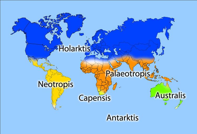
Botanist Ronald Good (1947) identified six floristic kingdoms (Boreal or Holarctic, Neotropical, Paleotropical, South African, Australian, and Antarctic), the largest natural units he determined for flowering plants. Good's six kingdoms are subdivided into smaller units, called provinces. The Paleotropical kingdom is divided into three subkingdoms, which are each subdivided into floristic provinces. Each of the other five kingdoms are subdivided directly into provinces. There are a total of 37 floristic provinces. Almost all provinces are further subdivided into floristic regions.
Takhtajan (1978, 1986) regionalization
Armen Takhtajan (1978, 1986), in a widely used scheme that builds on Good's work, identified thirty-five floristic regions, each of which is subdivided into floristic provinces, of which there are 152 in all.