Sneha Girap (Editor)

Chatham Islands

Updated on
Edit
Like
Comment
Share on FacebookTweet on TwitterShare on LinkedInShare on Reddit
Area
  
966 km²

Population
  
640 (2011)


The Chatham Islands form an archipelago in the Pacific Ocean about 680 kilometres (423 mi) southeast of mainland New Zealand. It consists of about ten islands within a 40-kilometre (25 mi) radius, the largest of which are Chatham Island and Pitt Island.

Contents

Map of Chatham Islands

The archipelago is called Rekohu ("misty sun") in the indigenous language Moriori, and Wharekauri in Maori. It has officially been part of New Zealand since 1842, and includes the countrys easternmost point, the Forty-Fours.

Rekohu a short film on the chatham islands


Geography

Chatham Islands Beautiful Landscapes of Chatham Islands

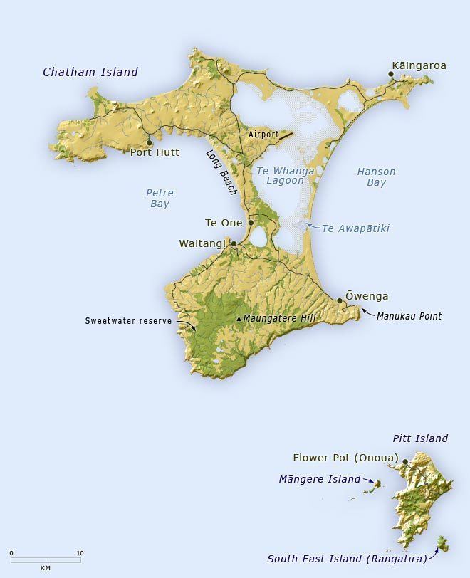
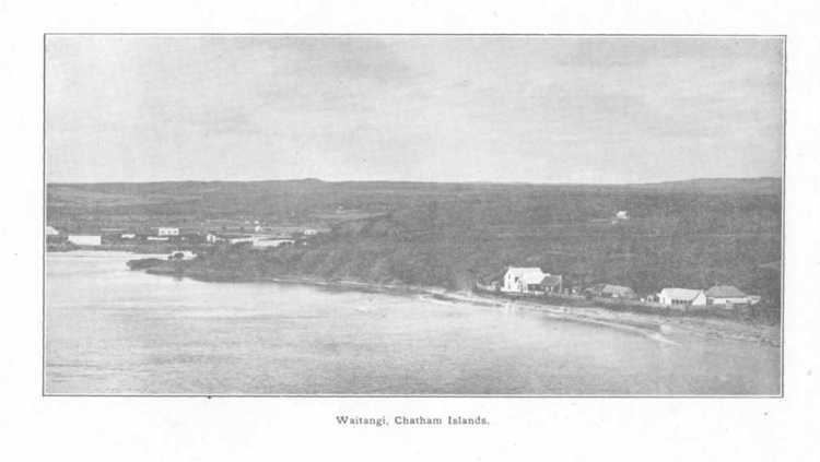
The islands are at about 43°53?S 176°31?W, roughly 840 kilometres (520 mi) east of Christchurch, New Zealand. The nearest mainland New Zealand point to the Chatham Islands is Cape Turnagain, in the North Island at a distance of 650 kilometres (400 mi). The nearest mainland New Zealand city to the islands is Hastings, New Zealand, located 697 kilometres (430 mi) to the North-West. The islands cover a total of 966 square kilometres (373 sq mi), almost all of which is in the two main islands.

Chatham Islands Beautiful Landscapes of Chatham Islands

The islands sit on the Chatham Rise, a large, relatively shallowly submerged (no more than 1,000 metres or 3,281 feet deep at any point) part of the Zealandia continent that stretches east from near the South Island. The Chatham Islands, which emerged only within the last four million years, are the only part of the Chatham Rise showing above sea level.

Chatham Island is the antipodes of the French department of Herault (Languedoc-Roussillon).

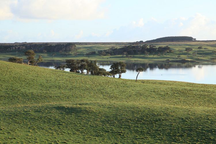
The islands are generally hilly with the coasts a varied mixture including cliffs and sand dunes, beaches, and lagoons. Pitt is more rugged than Chatham (Rekohu), although the highest point (299 metres or 981 feet) is on a plateau near the southernmost point of the main island, which is dotted with numerous lakes and lagoons, notably the large Te Whanga Lagoon, as well as Huro and Rangitahi. Chatham has a number of streams, including Te Awainanga and Tuku. The climate is cold, wet, and windy with average high temperatures between 5 and 10 °C (41 and 50 °F) in July, the Southern Hemisphere winter.

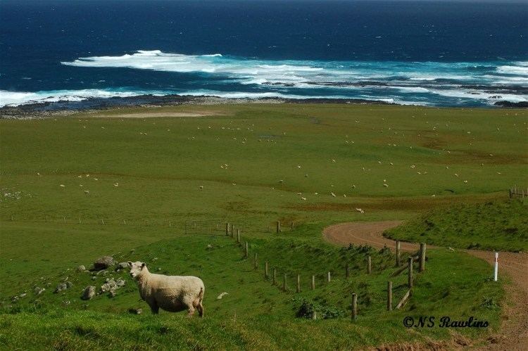
Chatham and Pitt are the only inhabited islands, with the remaining smaller islands being conservation reserves with access restricted or prohibited. The livelihoods of the inhabitants depend on agriculture, with the island being an exporter of coldwater crayfish in particular, and increasing tourism.

The names of the main islands, in the order of occupation are:

History

Chatham Islands in the past, History of Chatham Islands

The first human habitation of the Chathams was by migrating Polynesian tribes who settled the islands about 1500 CE, and in their isolation became the Moriori. The belief as to their origins was overturned late in the 20th century. The former belief, which arose in the 1800s, was that the original Moriori migrated directly from more northerly Polynesian islands, just as with the settlement of New Zealand by the ancestors of the Maori. However, linguistic research indicates instead that the ancestral Moriori were Maori wanderers from New Zealand. As Howe (2003) puts it,

Scholarship over the past 40 years has radically revised the model offered a century earlier by Smith: the Moriori as a pre-Polynesian people have gone (the term Moriori is now a technical term referring to those ancestral Maori who settled the Chatham Islands).

The plants cultivated by the Maori arrivals were ill suited for the colder Chathams, so the Moriori lived as hunter-gatherers and fishermen. While their new environment deprived them of the resources with which to build ocean-going craft for long voyages, the Moriori invented what was known as the waka korari, a semi-submerged craft, constructed of flax and lined with air bladders from kelp. This craft was used to travel to the outer islands on birding missions. The Moriori society was a peaceful society and bloodshed was outlawed by the chief Nunuku after generations of warfare. Arguments were solved by consensus or by duels rather than warfare, but at the first sign of bloodshed, the fight was over.

Economy

Most of the Chatham Island economy is based on fishing and crayfishing, with only a fragment of adventure tourism. This economic mix has been stable for the past 50 years, as little infrastructure or population is present to engage in higher levels of industrial or telecommunications activity.

Chatham Islands Culture of Chatham Islands
  • In Jules Vernes Robur the Conqueror, Robur anchors his flying vessel Albatross over the Chathams after the horizontal propellers are damaged in a storm.
  • The novel Cloud Atlas and its 2012 film adaptation includes the diary of a fictitious 19th century American traveller who passes through the Chathams.
  • In Joe Buffs futuristic nuclear submarine warfare novel Crush Depth (ISBN 0-06-000964-0), Chatham Island is destroyed by an Axis-planted atomic bomb.
  • References

    Chatham Islands Wikipedia (,)http://nzetc.victoria.ac.nz/etexts/GasSold/GasSold138a.jpg(,)http://upload.wikimedia.org/wikipedia/en/a/ab/Port_Blair_1872_Ross_Island_Penal_HQ.jpg(,)https://rekohu.files.wordpress.com/2008/03/punipi-1874.jpg(,)http://i228.photobucket.com/albums/ee174/whatakraka/Nukunono/Lagoon2.jpg(,)http://nzetc.victoria.ac.nz/etexts/Gov14_10Rail/Gov14_10Rail029a.jpg(,)https://p.gr-assets.com/540x540/fit/hostedimages/1379745875/98063.jpg(,)http://www.jps.auckland.ac.nz/docs/Volume064/images/JPS_064_426insert2_a.jpg(,)http://mysite.du.edu/~ttyler/ploughboy/cht56.jpg(,)http://mysite.du.edu/~ttyler/ploughboy/cht60.jpg(,)http://i1.trekearth.com/photos/147208/32660_-_chatham_island_sheep.jpg(,)https://c1.staticflickr.com/7/6034/6311063742_2f28d97ee7_b.jpg(,)http://i1.trekearth.com/photos/147208/32708_-_chatham_island_trees.jpg(,)http://nztony.smugmug.com/Chatham-Islands/i-S55BZW3/0/L/Chatham%2520Islands%2520Tree%2520Landscape-L.jpg(,)http://photorator.com/photos/images/abandoned-boat-in-the-chatham-islands-new-zealand34485.jpg(,)http://cache4.asset-cache.net/gc/503881237-new-zealand-chatham-island-hill-at-gettyimages.jpg%3Fv%3D1%26c%3DIWSAsset%26k%3D2%26d%3D9qW%252B1diSQq3rSy0cdKFHL%252BIKScnGG48ZS8Jkc6J0qHhDeTDvWpwwrUJKNZi%252FNEMu(,)https://c1.staticflickr.com/3/2877/13324563454_404eb0abe4_b.jpg(,)http://www.coastpalms.co.nz/core/wp-content/uploads/shop-images/Dscf2578%2520website.jpg(,)http://cache3.asset-cache.net/gc/503881247-new-zealand-chatham-island-tree-ferns-gettyimages.jpg%3Fv%3D1%26c%3DIWSAsset%26k%3D2%26d%3DXs8rLnzzOKH5%252FaXH6aAYmoyrrbncACc6qYRg3RnQuNw0OrCMlJDF30lUBKfRFNgS(,)http://cache1.asset-cache.net/gc/503881241-new-zealand-chatham-island-evening-cloud-gettyimages.jpg%3Fv%3D1%26c%3DIWSAsset%26k%3D2%26d%3D%252BqPpWCK4MZ5Z5%252F69Z%252FLn3sDnZ6AfUwEEpsRjCkjmUnbonLkNP7%252BWkZce%252B3mHcQc3(,)http://www.victoria.ac.nz/__data/assets/image/0020/214463/ISland-ecology-Kavanagh-2-wb.png(,)http://cache2.asset-cache.net/gc/503881251-new-zealand-chatham-island-red-cliffs-at-gettyimages.jpg%3Fv%3D1%26c%3DIWSAsset%26k%3D2%26d%3DFSdbXaLBP4cQMnVTiPjj9KJ4X7v0N2E%252BhWEL10ZpjqBwY%252FlNQDGl3%252BYaNQvk6YMk(,)http://www.tongariro.org.nz/uploads/89011/images/Kaye-with-Swans-eggs.jpg(,)http://chathamislandfood.com/wp-content/uploads/2012/07/Chatham_Island_Food__0074-1.jpg(,)http://chathamislandfood.com/wp-content/uploads/2012/07/Chatham_Island_Food__0070-1.jpg(,)https://pbs.twimg.com/media/BGzeFmhCQAAXu9j.jpg(,)http://cdn1.arkive.org/media/23/23030F28-28C2-44F4-90C3-DD07C14850FA/Presentation.Large/Close-up-of-Chatham-Island-tortoise-foot.jpg(,)https://mainweb-v.musc.edu/cando/kidsat/chatham/image2b.jpeg(,)http://cdn2.arkive.org/media/A0/A06DC71A-C2F8-4C49-8FEE-6A78E9D324E3/Presentation.Large/Chatham-Island-snipe-probing-for-food-amongst-leaf-litter.jpg(,)http://www.poutama.co.nz/newsletter/2013/jan-feb/images/05-Delwyn-Gigi.jpg(,)http://chathamislandfood.com/wp-content/uploads/2012/07/chatham_island_food_co1.jpg(,)http://www.teara.govt.nz/files/37775-enz.jpg(,)http://www.education-resources.co.nz/mikal.jpg(,)http://www.discoverthechathamislands.co.nz/content/images/111/640x480normal/DSCF1172.jpg(,)http://4.bp.blogspot.com/-FxqcnFM0DnI/Ub7QD4sYHpI/AAAAAAAADsc/lEmI4XNG-Bg/s1600/Chatham-Island_map_topo_en-1.png(,)http://www.discoverthechathamislands.co.nz/content/images/112/640x480normal/website_005.jpg(,)http://www.teara.govt.nz/files/p3923ar.jpg(,)http://www.teara.govt.nz/files/p1681ar.jpg(,)http://farm1.nzstatic.com/_proxy/imageproxy_1y/serve/new-zealands-chatham-islands-are-home-to-spectacular-stretches-of-coastline.webp%3Fheight%3D440%26outputformat%3Dwebp%26quality%3D80%26source%3D1243897%26transformationsystem%3Dcrop%26width%3D1280%26securitytoken%3D7655EAAE565FE51402DFD686EB0AFE54(,)http://www.californiaair.net/website/tours/tours/Concorde%2520Tour/images/leg7-2.JPG