
Length 394 km (245 mi) | Rank 38 Width 144 km (89 mi) | |
 | ||
Area 35,882.6258 km (13,854.3593 sq mi) Coastline 1,239.5756 km (770.2366 mi) | ||
Taiwan (historically known as Formosa, from Portuguese: Ilha Formosa, "Beautiful Island", [ˌiʎɐ fuɾˈmɔzɐ]) is an island in East Asia; located some 180 kilometres (112 miles) off the southeastern coast of mainland China across the Taiwan Strait. It has an area of 35,883 km2 (13,855 sq mi) and spans the Tropic of Cancer. The East China Sea lies to the north, the Philippine Sea to the east, the Luzon Strait directly to the south and the South China Sea to the southwest. Taiwan proper makes up 99% of the territory of the Free Area controlled by the Republic of China since the ROC lost its mainland China territory in the Chinese Civil War and fled to the island in 1949; this area itself is commonly referred to as simply "Taiwan".
Contents
- Physical boundaries
- Geology
- Terrain
- Climate
- Flora and fauna
- Human geography
- Environmental issues
- References
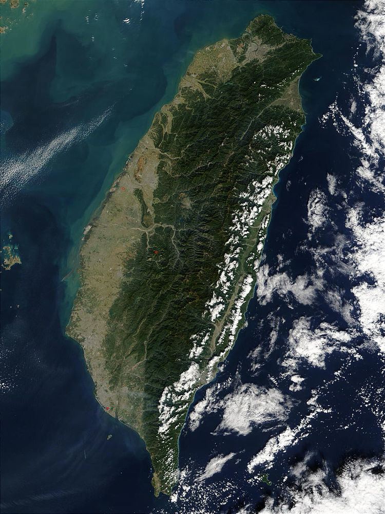
Taiwan is a tilted fault block, characterized by the contrast between the eastern two-thirds, consisting mostly of five rugged mountain ranges parallel to the east coast, and the flat to gently rolling plains of the western third, where the majority of Taiwan's population reside. There are several peaks over 3,500 m, the highest being Yu Shan at 3,952 metres (12,966 ft), making Taiwan the world's fourth-highest island. The tectonic boundary that formed these ranges is still active, and the island experiences many earthquakes, a few of them highly destructive. There are also many active submarine volcanoes in the Taiwan Straits.
The climate ranges from tropical in the south to subtropical in the north, and is governed by the East Asian Monsoon. The island is struck by an average of four typhoons in each year. The eastern mountains are heavily forested and home to a diverse range of wildlife, while land use in the western and northern lowlands is intensive.
Physical boundaries
The total area of the island is 36,193 km2 (13,974 sq mi), making it intermediate in size between Belgium and the Netherlands. It has a coastline of 1,139 km (708 mi). The ROC claims an exclusive economic zone of 200 nmi (370.4 km; 230.2 mi) and a territorial sea of 12 nmi (22.2 km; 13.8 mi).
The main island of the archipelago is the island of Taiwan, which is 394 km (245 mi) long, 144 km (89 mi) wide and has an area of 35,883 km2 (13,855 sq mi). The shape of the main island is similar to a sweet potato oriented in a south-to-north direction, and therefore Taiwanese, especially the Min Nan speakers, often call themselves "children of the Sweet Potato".
The central point of the island is the Geographic Center of Taiwan in Puli Township, Nantou County. The southernmost point of the island is the Taiwan Southernmost Point in Hengchun Township, Pingtung County.
The island of Taiwan is separated from the southeast coast of China by the Taiwan Strait, which ranges from 220 km (140 mi) at its widest point to 130 km (81 mi) at its narrowest. Part of the continental shelf, the Strait is no more than 100 m (330 ft) deep, and has become a land bridge during glacial periods.
To the south, the island of Taiwan is separated from the Philippine island of Luzon by the 250 km (155 mi)-wide Luzon Strait. The South China Sea lies to the southwest, the East China Sea to the north, and the Philippine Sea to the east.
Smaller islands of the archipelago include the Penghu islands in the Taiwan Strait 50 km (31 mi) west of the main island, with an area of 127 km2 (49 sq mi), the tiny islet of Xiaoliuqiu off the southwest coast, and Orchid Island and Green Island to the southeast, separated from the northernmost islands of the Philippines by the Bashi Channel. The islands of Kinmen and Matsu near the coast of Fujian across the Taiwan Strait have a total area of 180 km2 (69 sq mi); the Pratas and Taiping islets in the South China Sea are also administered by the ROC, but are not part of the Taiwanese archipelago.
Geology
The island of Taiwan was formed approximately 4 to 5 million years ago at a complex convergent boundary between the Philippine Sea Plate and the Eurasian Plate. In a boundary running the length of the island and continuing southwards in the Luzon Volcanic Arc (including Green Island and Orchid Island), the Eurasian Plate is sliding under the Philippine Sea Plate.
Most of the island comprises a huge fault block tilted to the west. The western part of the island, and much of the central range, consists of sedimentary deposits scraped from the descending edge of the Eurasian Plate. In the northeast of the island, and continuing eastwards in the Ryukyu Volcanic Arc, the Philippine Sea Plate slides under the Eurasian Plate.
The tectonic boundary remains active, and Taiwan experiences 15,000 to 18,000 earthquakes each year, of which 800 to 1,000 are noticed by people. The most catastrophic recent earthquake was the magnitude-7.3 Chi-Chi earthquake, which occurred in the center of Taiwan on 21 September 1999, killing more than 2,400 people. On 4 March 2010 at about 01:20 UTC, a magnitude 6.4 earthquake hit southwestern Taiwan in the mountainous area of Kaohsiung County. Another major earthquake occurred on 6 February 2016, with a magnitude of 6.4. Tainan was damaged the most, with a 17-story apartment building collapsing and a total of 41 dead, 535 injured, and 109 missing.
Terrain
The terrain in Taiwan is divided into two parts: the flat to gently rolling plains in the west, where 90% of the population lives, and the mostly rugged forest-covered mountains in the eastern two-thirds.
The eastern part of the island is dominated by five mountain ranges, each running from north-northeast to south-southwest, roughly parallel to the east coast of the island. As a group, they extend 330 km (210 mi) from north to south and average about 80 kilometres (50 mi) from east to west. They include more than two hundred peaks with elevations of over 3,000 m (9,800 ft).
The Central Mountain Range extends from Su'ao in the northeast to Eluanbi at the southern tip of the island, forming a ridge of high mountains and serving as the island's principal watershed. The mountains are predominantly composed of hard rock formations resistant to weathering and erosion, although heavy rainfall has deeply scarred the sides with gorges and sharp valleys. The relative relief of the terrain is usually extensive, and the forest-clad mountains with their extreme ruggedness are almost impenetrable. The east side of the Central Mountain Range is the steepest mountain slope in Taiwan, with fault scarps ranging in height from 120 to 1,200 m (390 to 3,900 ft). Taroko National Park, on the steep eastern side of the range, has good examples of mountainous terrain, gorges and erosion caused by a swiftly flowing river.
The East Coast Mountain Range extends down the east coast of the island from the mouth of the Hualien River in the north to Taitung County in the south, and chiefly consist of sandstone and shale. It is separated from the Central Range by the narrow Huatung Valley, at an altitude of 120 m (390 ft). Although Hsinkangshan (新港山), the highest peak, reaches an elevation of 1,682 m (5,518 ft), most of the range is composed of large hills. Small streams have developed on the flanks, but only one large river cuts across the range. Badlands are located at the western foot of the range, where the ground water level is the lowest and rock formations are the least resistant to weathering. Raised coral reefs along the east coast and the frequent occurrences of earthquakes in the rift valley indicate that the fault block is still rising.
The ranges to the west of the Central range are divided into two groups separated by the Sun Moon Lake Basin in the centre of the island. The Dadu and Zhuoshui Rivers flow from the western slopes of the Central Range through the basin to the west coast of the island.
The Xueshan Range lies to the northwest of the Central Mountain Range, beginning at Sandiaojiao, the northeast tip of the island, and gaining elevation as it extends southwest towards Nantou County. Xueshan, the main peak, is 3,886 m (12,749 ft) high.
The Yushan Range runs along the southwestern flank of the Central Range. It includes the island's tallest peak, the 3,952 m (12,966 ft) Jade Mountain (Yu Shan), which makes Taiwan the world's fourth-highest island, and is the highest point in the western Pacific region outside of the Kamchatka Peninsula.
The Alishan Range lies west of the Yushan Range, across the valley of the south-flowing Kaoping River. The range has major elevations between 1,000 and 2,000 m (3,300 and 6,600 ft). The main peak, Data Mountain (大塔山), towers 2,663 m (8,737 ft).
Below the western foothills of the ranges, such as the Hsinchu Hills and the Miaoli Hills, lie raised terraces formed of material eroded from the ranges. These include the Linkou Plateau, the Taoyuan Plateau and the Dadu Plateau. About 23% of Taiwan's land area consists of fertile alluvial plains and basins watered by rivers running from the eastern mountains. Over half of this land lies in the Chianan Plain in southwest Taiwan, with lesser areas in the Pingtung Plain, Taichung Basin and Taipei Basin. The only sizable plain on the east coast is the Yilan Plain in the northeast.
Climate
The island of Taiwan lies across the Tropic of Cancer, and its climate is influenced by the East Asian Monsoon. Northern and central Taiwan has a humid subtropical climate, with substantial seasonal variation of temperatures, while most of southern and south eastern Taiwan has a tropical monsoon climate where seasonal temperature variations are less noticeable with temperatures typically varying from warm to hot. During the winter (November to March), the northeast experiences steady rain, while the central and southern parts of the island are mostly sunny. The summer monsoon (from May to October) accounts for 90% of the annual precipitation in the south, but only 60% in the north. The average rainfall is approximately 2,600 mm per year.
Typhoons are most likely to strike between July and October, with on average about four direct hits per year. Intensive rain from typhoons often leads to disastrous mudslides.
Flora and fauna
Before extensive human settlement, the vegetation on Taiwan ranged from tropical rainforest in the lowlands through temperate forests, boreal forest and alpine plants with increasing altitude. Most of the plains and low-lying hills of the west and north of the island have been cleared for agricultural use since the arrival of the Chinese immigrants during the 17th and 18th century. However the mountain forests are very diverse, with several endemic species such as Formosan cypress (Chamaecyparis formosensis) and Taiwan fir (Abies kawakamii), while the camphor laurel (Cinnamomum camphora) was once also widespread at lower altitudes.
Taiwan is a center of bird endemism (see List of endemic birds of Taiwan).
Prior to the country's industrialization, the mountainous areas held several endemic animal species and subspecies, such as the Swinhoe's pheasant (Lophura swinhoii), Taiwan blue magpie (Urocissa caerulea), the Formosan sika deer (Cervus nippon taiwanensis or Cervus nippon taiouanus) and the Formosan landlocked salmon (Oncorhynchus masou formosanus). A few of these are now extinct, and many others have been designated endangered species.
Taiwan had relatively few carnivores, 11 species in total, of which the Formosan clouded leopard and otter are likely extinct. The largest carnivore is the Formosan black bear (Selanarctos thibetanus formosanus), a rare and endangered species.
Nine national parks in Taiwan showcase the diverse terrain, flora and fauna of the archipelago. Kenting National Park on the southern tip of Taiwan contains uplifted coral reefs, moist tropical forest and marine ecosystems. Yushan National Park has alpine terrain, mountain ecology, forest types that vary with altitude, and remains of ancient road. Yangmingshan National Park has volcanic geology, hot springs, waterfalls, and forest. Taroko National Park has marble canyon, cliff, and fold mountains. Shei-Pa National Park has alpine ecosystems, geological terrain, and valley streams. Kinmen National Park has lakes, wetlands, coastal topography, flora and fauna-shaped island. Dongsha Atoll National Park has the Pratas reef atolls for integrity, a unique marine ecology, biodiversity, and is a key habitat for the marine resources of the South China Sea and Taiwan Strait.
Human geography
Taiwan has a population of over 23 million, the vast majority of whom live in the lowlands near the western coast of the island. The island is highly urbanized, with nearly 9 million people living in the Taipei–Keelung–Taoyuan metropolitan area at the northern end, and over 2 million each in the urban areas of Kaohsiung and Taichung.
Taiwanese aborigines comprise approximately 2% of the population, and now mostly live in the mountainous eastern part of the island. Most scholars believe their ancestors arrived in Taiwan by sea between 4000 and 3000 BC, probably from the mainland.
Han Chinese make up over 95% of the population. Immigrants from southern Fujian began to farm the area around modern Tainan and Kaohsiung from the 17th century, later spreading across the western and northern plains and absorbing the aboriginal population of those areas. Hakka people from eastern Guangdong arrived later and settled the foothills further inland, but the rugged uplands of the eastern half of the island remained the exclusive preserve of the aborigines until the early 20th century. A further 1.2 million people from throughout mainland China entered Taiwan at the end of the Chinese Civil War in 1949.
Environmental issues
Some areas in Taiwan with high population density and many factories are affected by heavy pollution. The most notable areas are the southern suburbs of Taipei and the western stretch from Tainan to Lin Yuan, south of Kaohsiung. In the late 20th century, Taipei suffered from extensive vehicle and factory air pollution, but with mandatory use of unleaded petrol and the establishment of the Environmental Protection Administration in 1987, the air quality of Taiwan has improved dramatically. Motor scooters, especially older or cheaper two-stroke versions, which are ubiquitous in Taiwan, also contribute disproportionately to urban air pollution.
Other environmental issues include water pollution from industrial emissions and raw sewage, contamination of drinking water supplies, and trade in endangered species. Though regulation of sulfate aerosol emissions from petroleum combustion is becoming stringent, acid rain remains a threat to the health of residents and forests. Atmospheric scientists in Taiwan estimate that more than half of the pollutants causing Taiwan's acid rain are carried from mainland China by monsoon winds.