
 | ||
A biome /ˈbaɪoʊm/ is a formation of plants and animals that have common characteristics due to similar climates and can be found over a range of continents. Spanning continents, biomes are distinct biological communities that have formed in response to a shared physical climate. Biomes are distinct from habitats, because any biome can comprise a variety of habitats.
Contents
- History of the concept
- Classifications
- Holdridge 1947 1964 life zones
- Allee 1949 biome types
- Kendeigh 1961 biomes
- Whittaker 1962 1970 1975 biome types
- Key definitions for understanding Whittakers scheme
- Whittakers parameters for classifying biome types
- Biome types
- Goodall 1974 ecosystem types
- Walter 1976 2002 zonobiomes
- Schltz 1988 ecozones
- Bailey 1989 ecoregions
- Olson Dinerstein 1998 biomes for WWF Global 200
- Biogeographic realms terrestrial and freshwater
- Biogeographic realms marine
- Biomes terrestrial
- Biomes freshwater
- Biomes marine
- Summary of the scheme
- Marine biomes
- Anthropogenic biomes
- Endolithic biomes
- Dermal biome
- References
A biome contrasts with a microbiome. A microbiome is also a mix of organisms that coexist in a defined space, but on a much smaller scale. For example, the human microbiome is the collection of bacteria, viruses, and other microorganisms that are present on a human.
A 'biota' is the total collection of organisms of a geographic region or a time period, from local geographic scales and instantaneous temporal scales all the way up to whole-planet and whole-timescale spatiotemporal scales. The biotas of the Earth make up the biosphere.
History of the concept
The term was suggested in 1916 by Clements, originally as a synonym for biotic community of Möbius (1877). Later, it gained its current definition, based on earlier concepts of phytophysiognomy, formation and vegetation (used in opposition to flora), with the inclusion of the animal element and the exclusion of the taxonomic element of species composition. In 1935, Tansley would add the climatic and soil aspects to the idea, calling it ecosystem. The International Biological Program (1964–74) projects would popularize the concept of biome.
However, in some contexts, the term biome is used in a different manner. In German literature, particularly in the Walter terminology, the term is used similarly as biotope (a concrete geographycal unit), while the biome definition used in this article is used as a international, non-regional, terminology - irrespectively of the continent in which an area is present, it takes the same biome name - and corresponds to his "zonobiome", "orobiome" and "pedobiome" (biomes determinated by climate zone, altitude or soil).
In Brazilian literature, the term "biome" is sometimes used as synonym of "biogeographic province", an area based on species composition (the term "floristic province" being used when plant species are considered), or also as synonym of the "morphoclimatic and phytogeographical domain" of Ab'Sáber, a geographic space with subcontinental dimensions, with the predominance of similar geomorphologic and climatic characteristics, and of a certain vegetation form. Both includes many biomes in fact.
Classifications
To divide the world in a few ecological zones is a difficult attempt, notably because of the small-scale variations that exist everywhere on earth and because of the gradual changeover from one biome to the other. Their boundaries must therefore be drawn arbitrarily and their characterization made according to the average conditions that predominate in them.
A 1978 study on North American grasslands found a positive logistic correlation between evapotranspiration in mm/yr and above-ground net primary production in g/m2/yr. The general results from the study were that precipitation and water use led to above-ground primary production, while solar irradiation and temperature lead to below-ground primary production (roots), and temperature and water lead to cool and warm season growth habit. These findings help explain the categories used in Holdridge’s bioclassification scheme (see below), which were then later simplified by Whittaker. The number of classification schemes and the variety of determinants used in those schemes, however, should be taken as strong indicators that biomes do not fit perfectly into the classification schemes created.
Holdridge (1947, 1964) life zones
Holdridge classified climates based on the biological effects of temperature and rainfall on vegetation under the assumption that these two abiotic factors are the largest determinants of the types of vegetation found in a habitat. Holdridge uses the four axes to define 30 so-called "humidity provinces", which are clearly visible in his diagram. While this scheme largely ignores soil and sun exposure, Holdridge acknowledged that these were important.
Allee (1949) biome-types
The principal biome-types by Allee (1949):
Kendeigh (1961) biomes
The principal biomes of the world by Kendeigh (1961):
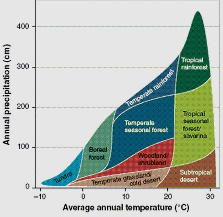
Whittaker (1962, 1970, 1975) biome-types
Whittaker classified biomes using two abiotic factors: precipitation and temperature. His scheme can be seen as a simplification of Holdridge's; more readily accessible, but missing Holdridge's greater specificity.
Whittaker based his approach on theoretical assertions and empirical sampling. He was in a unique position to make such a holistic assertion because he had previously compiled a review of biome classifications.
Key definitions for understanding Whittaker's scheme
Whittaker's distinction between biome and formation can be simplified: formation is used when applied to plant communities only, while biome is used when concerned with both plants and animals. Whittaker's convention of biome-type or formation-type is simply a broader method to categorize similar communities.
Whittaker's parameters for classifying biome-types
Whittaker, seeing the need for a simpler way to express the relationship of community structure to the environment, used what he called "gradient analysis" of ecocline patterns to relate communities to climate on a worldwide scale. Whittaker considered four main ecoclines in the terrestrial realm.
- Intertidal levels: The wetness gradient of areas that are exposed to alternating water and dryness with intensities that vary by location from high to low tide
- Climatic moisture gradient
- Temperature gradient by altitude
- Temperature gradient by latitude
Along these gradients, Whittaker noted several trends that allowed him to qualitatively establish biome-types:
Whittaker summed the effects of gradients (3) and (4) to get an overall temperature gradient, and combined this with gradient (2), the moisture gradient, to express the above conclusions in what is known as the Whittaker classification scheme. The scheme graphs average annual precipitation (x-axis) versus average annual temperature (y-axis) to classify biome-types.
Biome-types
• 26. Wetland
Goodall (1974-) ecosystem types
The multiauthored series Ecosystems of the world, edited by David W. Goodall, provides a comprehensive coverage of the major "ecosystem types or biomes" on earth:
Walter (1976, 2002) zonobiomes
The eponymously-named Heinrich Walter classification scheme considers the seasonality of temperature and precipitation. The system, also assessing precipitation and temperature, finds nine major biome types, with the important climate traits and vegetation types. The boundaries of each biome correlate to the conditions of moisture and cold stress that are strong determinants of plant form, and therefore the vegetation that defines the region. Extreme conditions, such as flooding in a swamp, can create different kinds of communities within the same biome.
Schültz (1988) ecozones
Schültz (1988) defined nine ecozones (note that his concept of ecozone is more similar to the concept of biome used in this article than to the concept of ecozone of BBC):
Bailey (1989) ecoregions
Robert G. Bailey nearly developed a biogeographical classification system of ecoregions for the United States in a map published in 1976. He subsequently expanded the system to include the rest of North America in 1981, and the world in 1989. The Bailey system, based on climate, is divided into seven domains (polar, humid temperate, dry, humid, and humid tropical), with further divisions based on other climate characteristics (subarctic, warm temperate, hot temperate, and subtropical; marine and continental; lowland and mountain).
Olson & Dinerstein (1998) biomes for WWF / Global 200
A team of biologists convened by the World Wildlife Fund (WWF) developed a scheme that divided the world's land area into biogeographic realms (called "ecozones" in a BBC scheme), and these into ecoregions (Olson & Dinerstein, 1998, etc.). Each ecoregion is characterized by a main biome (also called major habitat type).
This classification is used to define the Global 200 list of ecoregions identified by the WWF as priorities for conservation.
For the terrestrial ecoregions, there is a specific EcoID, format XXnnNN (XX is the biogeographic realm, nn is the biome number, NN is the individual number).
Biogeographic realms (terrestrial and freshwater)
It should be noted, however, that the applicability of the realms scheme above - based on Udvardy (1975) - to most freshwater taxa is unresolved.
Biogeographic realms (marine)
Biomes (terrestrial)
Biomes (freshwater)
According to the WWF, the following are classified as freshwater biomes:
Biomes (marine)
Biomes of the coastal and continental shelf areas (neritic zone):
Summary of the scheme
Example:
Marine biomes
Pruvot (1896) zones or "systems":
Longhurst (1998) biomes:
Other marine habitat types (not covered yet by the Global 200/WWF scheme):
Anthropogenic biomes
Humans have altered global patterns of biodiversity and ecosystem processes. As a result, vegetation forms predicted by conventional biome systems can no longer be observed across much of Earth's land surface as they have been replaced by crop and rangelands or cities. Anthropogenic biomes provide an alternative view of the terrestrial biosphere based on global patterns of sustained direct human interaction with ecosystems, including agriculture, human settlements, urbanization, forestry and other uses of land. Anthropogenic biomes offer a new way forward in ecology and conservation by recognizing the irreversible coupling of human and ecological systems at global scales and moving us toward an understanding of how best to live in and manage our biosphere and the anthropogenic biomes we live in.
Major anthropogenic biomes:
Endolithic biomes
The endolithic biome, consisting entirely of microscopic life in rock pores and cracks, kilometers beneath the surface, has only recently been discovered, and does not fit well into most classification schemes.
Dermal biome
The dermal biome is the living ecosystem that animals (including humans) have evolved, that permits them to live symbiotically and in balance with the microbes on and in them (the microbiome). This ecosystem consists of skin, follicles, hair, sebaceous glands, sweat glands, arrector pili muscles, peptides, proteins, lipids and its associated microbiota. A healthy dermal biome has several functions: it resists infection of pathogens, protects against moisture loss and water damage, dynamically regulates body temperature and supports the healthy renewal of skin through the epidermal cell life cycle.