The Sahel (pronounced as "suh-Hail" or "suh-Heel") is the ecoclimatic and biogeographic zone of transition in Africa between the Sahara Desert to the north and the Sudanian Savanna to the south. Having a semi-arid climate, it stretches across the southernmost extent of Northern Africa between the Atlantic Ocean and the Red Sea. The Arabic word sahil () literally means "shore, coast", describing the appearance of the vegetation found in the Sahel as being akin to that of a coastline delimiting the sand of the Sahara.
The Sahel [p] covers parts of (from west to east) Senegal, southern Mauritania, central Mali, northern Burkina Faso, extreme south of Algeria, Niger, extreme north of Nigeria, central Chad, central and southern Sudan, northern South Sudan and northern Eritrea.

The Sahel spans 5,400 km (3,360 mi) from the Atlantic Ocean in the west to the Red Sea in the east, in a belt that varies from several hundred to a thousand kilometers (620 miles) in width, covering an area of 3,053,200 square kilometers (1,178,850 sq mi). It is a transitional ecoregion of semi-arid grasslands, savannas, steppes, and thorn shrublands lying between the wooded Sudanian savanna to the south and the Sahara to the north.
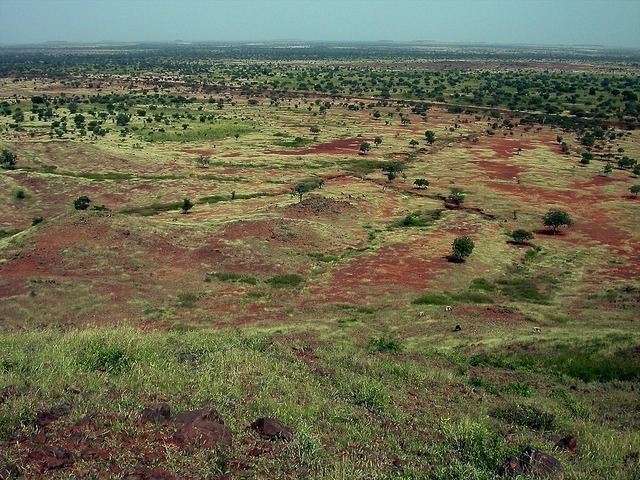
The topography of the Sahel is mainly flat, and the region mostly lies between 200 and 400 meters (660 and 1,310 ft) in elevation. Several isolated plateaus and mountain ranges rise from the Sahel, but are designated as separate ecoregions because their flora and fauna are distinct from the surrounding lowlands. Annual rainfall varies from around 100 mm (4 in)-200 mm (8 in), in the north of the Sahel, to around 600 mm (24 in) in the south.
Over the history of Africa, the region has been home to some of the most advanced kingdoms, benefiting from trade across the desert. Collectively, these states are known as the Sahelian kingdoms.
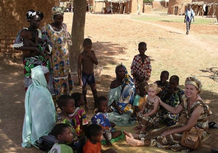
Traditionally, most of the people in the Sahel have been semi-nomads, farming and raising livestock in a system of transhumance, which is probably the most sustainable way of utilizing the Sahel. The difference between the dry north with higher levels of soil-nutrients and the wetter south is utilized so that the herds graze on high quality feed in the North during the wet season, and trek several hundred kilometers down to the south, to graze on more abundant, but less nutritious feed during the dry period. Increased permanent settlement and pastoralism in fertile areas has been the source of conflicts with traditional nomadic herders.

In Western Sahel, polygamous and child marriages are common. Female genital mutilation (FGM) is also practiced across the Sahel.
The first instances of domestication of plants for agricultural purposes in Africa occurred in the Sahel region circa 5000 BC, when sorghum and African rice began to be cultivated. Around this time, and in the same region, the small Guineafowl were domesticated.
Around 4000 BC the climate of the Sahara and the Sahel started to become drier at an exceedingly fast pace. This climate change caused lakes and rivers to shrink rather significantly and caused increasing desertification. This, in turn, decreased the amount of land conducive to settlements and helped to cause migrations of farming communities to the more humid climate of West Africa.
(Text) CC BY-SA
(,)http://upload.wikimedia.org/wikipedia/commons/1/18/Ghana_empire_map.png(,)http://static-content.springer.com/lookinside/art%253A10.1007%252Fs00334-010-0279-6/000.png(,)http://upload.wikimedia.org/wikipedia/commons/c/ce/Great_Mosque_of_Djenn%25C3%25A9_1.jpg(,)http://upload.wikimedia.org/wikipedia/commons/8/8b/CentralEastAfrica1750.png(,)http://placekitten.com/738/738(,)http://upload.wikimedia.org/wikipedia/commons/0/03/East_and_southern_africa_early_iron_age.png(,)http://static-content.springer.com/lookinside/chp%253A10.1007%252F978-1-4757-6730-8_7/000.png(,)http://upload.wikimedia.org/wikipedia/commons/8/83/African_slave_trade.png(,)http://upload.wikimedia.org/wikipedia/commons/4/47/WestAfrica1625.png(,)https://c2.staticflickr.com/6/5105/5656407416_61c61164b5_b.jpg(,)http://www.motherjones.com/files/sahel_landscape.jpg(,)http://aminus3.s3.amazonaws.com/image/g0010/u00009969/i00864029/8169e9c19622004306d327126681dc08_large.jpg(,)http://courses.wcupa.edu/jones/his311/archives/pix/termite.gif(,)http://www.american-buddha.com/ecologyforecastdry5.jpg(,)http://freevst.x10.mx/sahara/sahara/geography/sahara%252004.jpg(,)http://farm3.staticflickr.com/2713/4363895902_489d8dffd2_b.jpg(,)http://www.american-buddha.com/ecologyforecastdry11.jpg(,)http://www.english-online.at/geography/sahel-zone/sahel-zone-in-senegal.jpg(,)http://farm1.static.flickr.com/141/373261546_86b0d67b5d_b.jpg(,)http://www.aljazeera.com/mritems/images/2012/6/24/2012624215938822282_8.jpg(,)http://image.slidesharecdn.com/2nyonggloballandscapefinal-131125011936-phpapp01/95/food-security-and-adapting-to-climate-change-in-the-sahel-a-landscape-approach-2-638.jpg%3Fcb%3D1385342572(,)http://nanjaandjelle.50webs.com/WestAfrica/0450Nanja-Jelle-Djenne-Mali-2005.jpg(,)http://farm1.staticflickr.com/27/38838721_354f4acdb0_b.jpg(,)http://farm6.staticflickr.com/5221/5655819349_c45f5afaf0_z.jpg(,)http://www.aluminiumdusahel.com/wp-content/uploads/2012/04/P2170023.jpg(,)http://www.aluminiumdusahel.com/wp-content/uploads/2012/04/SAM_0766.jpg(,)http://www.moxon.net/images/mali/570/sahel_food1.jpg(,)https://cdn.jovago.com/web_hotel_detail_gallery/sahel-suites-and-gardens-4974-b1e0ecacd62816341f91fabe34e2b48b4c144fa1.jpg(,)http://visitabudhabi.ae/DataFolder/Images/Thumbnails/900x600//02-Al-Sahel-Bedroom.jpg(,)http://www.dotwnews.com/modules/image_resize/image_resize.php%3Fimage%3D/uploads/posts/62845791-H1-One_Bedroom_Villa.gif%26width%3D582%26height%3D365%26cropratio%3D582:365(,)http://s5.splcdn.net/images/hotels/49580/abu-dhabi-anantara-sir-bani-yas-island-al-sahel-villas-372359_1000_560.jpg(,)http://www.whereleb.com/img/placespictures/662/66219/full/66219_232.jpg(,)http://www.sirbaniyasisland.com/Admin/Content/Al-Sahel-Bay-Window_0014a.jpg(,)http://cdn.theatlantic.com/static/mt/assets/international/sahel-food-crisis-unhcr_bnr.jpg(,)http://al-sahel.anantara.com/uploads/hotels/dining/Al_Sahel_Anantara_Savannah_Grill-restaurant-198.jpg(,)http://aff.bstatic.com/images/hotel/max500/173/17380742.jpg(,)http://aff.bstatic.com/images/hotel/max500/184/18475868.jpg(,)http://aff.bstatic.com/images/hotel/max500/173/17380681.jpg(,)http://al-sahel.anantara.com/uploads/hotels/dining/Al_Sahel_Dining_by_Design-200.jpg(,)http://aff.bstatic.com/images/hotel/max500/173/17380689.jpg(,)http://www.saheldesign.com/wp-content/uploads/2011/12/Charlie_Davies_SAHEL_projects.jpg(,)http://www.visitgaomali.com/MuseumoftheSahel4.JPG(,)http://36.media.tumblr.com/tumblr_mc2dx4kz6w1qdqgjdo3_1280.png(,)http://static.euronews.com/articles/303783/606x340_303783.jpg%3F1428571805(,)https://dianabuja.files.wordpress.com/2012/05/mueller-sahel2.jpg%3Fw%3D640(,)http://paulturounetblog.files.wordpress.com/2007/10/salgado_greenfield.jpg(,)http://p1.img.cctvpic.com/photoworkspace/contentimg/2015/04/09/2015040910205099301.jpg(,)http://thecultureist.com/wp-content/uploads/2012/06/sahel.jpg(,)http://3.bp.blogspot.com/-u_d6vY7i8gA/VHn7XAbLpFI/AAAAAAAAJ4g/oPoBxw8iFPY/s1600/Bororo_0020_Girls.jpg(,)http://www.btcycle.com/wp-content/uploads/2010/02/6dTastingthewildfigs.jpg(,)http://www.worldmusic.net/media/articles/article/1025.jpg(,)https://s-media-cache-ak0.pinimg.com/736x/fb/97/81/fb978128ea3c97b164aa19465e32a969.jpg