
Country United States County Contra Costa Elevation 23 ft (7 m) Zip code 94553 Area code 925 | State California Incorporated April 1, 1876 Local time Monday 5:22 PM Population 37,165 (2013) | |
 | ||
Weather 25°C, Wind NE at 10 km/h, 43% Humidity | ||
Martinez (/mɑːrˈtiːnᵻs/ mar-TEE-niss or /mɑːrˈtiːnɛθ/ mar-TEE-neth; Spanish: Martínez) is a city and the county seat of Contra Costa County, California, in the East Bay of the San Francisco Bay Area. The population was 35,824 at the 2010 census. The downtown is notable for its large number of preserved old buildings and antique shops. Martinez is located on the southern shore of the Carquinez Strait in the San Francisco Bay Area, directly facing the city center of Benicia and the southeastern end of Vallejo, California.
Contents
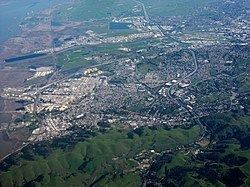
- Map of Martinez CA 94553 USA
- History
- Geography
- Climate
- 2010
- 2000
- Top employers
- Sister cities
- Rail
- Bus
- Major highways
- Media
- Education
- Public libraries
- Notable people
- References
Map of Martinez, CA 94553, USA
History
In 1824 the Alhambra Valley was included in the Rancho El Pinole Mexican land grant to Ygnacio Martínez. In 1847, Dr. Robert Semple contracted to provide ferry service from Martinez to Benicia, which for many years was the only crossing on the Carquinez Strait. By 1849, Martínez served as a way station for the California Gold Rush. The town was laid out in 1849 by Col. William M. Smith and named for Martinez. It became the county seat in 1850, but could not incorporate at the time because it lacked the 200 registered voters required, and only became a city in 1876.
Martinez was the home of naturalist John Muir from 1880 until his death in 1914. He was buried about a mile south of the building that is now the John Muir National Historic Site. Also nearby is the Vicente Martinez Adobe, built in 1849 by the son of Ygnacio Martinez.
The first post office opened in 1851.
In 1860, Martinez played a role in the Pony Express, where riders would take the ferry from Benicia (particularly if they missed the steamer in Sacramento). In 1915, Shell Oil Company built an oil refinery in unincorporated Martinez, which sparked a building boom in the area. A second area refinery (presently owned by Tesoro Petroleum Co.), together with the Shell facilities, help make Martinez a significant petroleum processing center and port. The oil refineries in and near Martinez can still be seen today from Interstate 680.
Folk etymology in Martinez claims the invention of the Martini cocktail and that it is named for the city.
Geography
According to the United States Census Bureau, the city has a total area of 13.1 square miles (34 km2), of which, 12.1 square miles (31 km2) of it is land and 1.0 square mile (2.6 km2) of it (7.64 percent) is water.
Although the common perception of Martinez is that of a refinery town, given the view from Highway 680 across the Shell refinery from the Benicia–Martinez Bridge, the city is in fact largely surrounded by water and regional open space preserves. The Martinez–Benicia Bridge carries Highway 680 across the eastern end of the Carquinez Strait to Solano County. The city can be defined as a more densely built downtown valley threaded by Alhambra creek and north of Highway 4. Suburban areas stretch south of Highway 4 to join the neighboring city of Pleasant Hill. Unincorporated areas include the rural Alhambra Valley and the Franklin Canyon area.
The Martinez Regional Shoreline bounds the city to the north along the Carquinez Strait. Carquinez Strait Regional Shoreline includes the Franklin Hills west of downtown, stretching west to the unincorporated community of Port Costa and the town of Crockett. Briones Regional Park borders the Alhambra Valley to the south. Waterbird Regional Preserve and the McNabney Marsh border the city and Highway 680 to the east. Martinez's location at the east end of the Carquinez Strait as it widens to Suisun Bay includes dramatic water views stretching to the Sierra range. From surrounding ridge tops views stretch to nearby Mt. Diablo, Mt. St. Helena, Mt. Tamalpais, etc.
Martinez is one of the only two places in the Bay Area, the other being Golden Gate Bridge, where the Bay Area Ridge Trail and the San Francisco Bay Trail converge. The Bay Trail is a planned recreational corridor that, when complete, will encircle San Francisco and San Pablo bays with a continuous 400-mile (640 km) network of bicycling and hiking trails. It will connect the shoreline of all nine Bay Area counties, link 47 cities, and cross the major toll bridges in the region, including the Benicia–Martinez Bridge. To date, approximately 240 miles (390 km) of the alignment—over half the Bay Trail's ultimate length—have been completed. The Bay Area Ridge Trail ultimately will be a 500+ mile trail encircling the San Francisco Bay along the ridge tops, open to hikers, equestrians, mountain bicyclists, and outdoor enthusiasts of all types. So far, over 300 miles (480 km) of trail have been dedicated for use. East Bay Regional Park District's Iron Horse Regional Trail will join the Bay Trail along the waterfront, and the Contra Costa Canal Trail threads through the city from Pleasant Hill to the south.
Climate
Martinez has a mild mediterranean climate (Köppen climate classification Csa/b). Summers are warm and dry, with some morning fog during sea breezes. The maritime influence is much less significant than in other parts of the Bay Area that are closer to the Pacific, which causes very high daytime averages compared to San Francisco and Oakland in summer. However, nights normally cool off significantly which results in daytime highs of around 87 °F (31 °C) and night time lows of 55 °F (13 °C) during July and August. Winters are wet and cool with occasional frost. The majority of the city is within a USDA hardiness zone of 9b.
2010
The 2010 United States Census reported that Martinez had a population of 35,824. The population density was 2,727.4 people per square mile (1,053.1/km²). The racial makeup of Martinez was 27,603 (77.1%) White, 1,303 (3.6%) African American, 255 (0.7%) Native American, 2,876 (8.0%) Asian, 121 (0.3%) Pacific Islander, 1,425 (4.0%) from other races, and 2,241 (6.3%) from two or more races. Hispanic or Latino of any race were 5,258 persons (14.7 percent).
The Census reported that 34,528 people (96.4 percent of the population) lived in households, 235 (0.7 percent) lived in non-institutionalized group quarters, and 1,061 (3.0 percent) were institutionalized.
There were 14,287 households, out of which 4,273 (29.9 percent) had children under the age of 18 living in them, 6,782 (47.5 percent) were opposite-sex married couples living together, 1,751 (12.3 percent) had a female householder with no husband present, 640 (4.5 percent) had a male householder with no wife present. There were 928 (6.5 percent) unmarried opposite-sex partnerships, and 137 (1.0 percent) same-sex married couples or partnerships. 3,920 households (27.4 percent) were made up of individuals and 1,078 (7.5 percent) had someone living alone who was 65 years of age or older. The average household size was 2.42. There were 9,173 families (64.2 percent of all households); the average family size was 2.95.
The age distribution of the population showed 7,329 people (20.5 percent) under the age of 18, 2,842 people (7.9 percent) aged 18 to 24, 9,193 people (25.7 percent) aged 25 to 44, 12,121 people (33.8 percent) aged 45 to 64, and 4,339 people (12.1 percent) who were 65 years of age or older. The median age was 42.2 years. For every 100 females there were 96.9 males. For every 100 females age 18 and over, there were 94.8 males.
There were 14,976 housing units at an average density of 1,140.2 per square mile (440.2/km²), of which 9,619 (67.3 percent) were owner-occupied, and 4,668 (32.7 percent) were occupied by renters. The homeowner vacancy rate was 1.4 percent; the rental vacancy rate was 4.9 percent. 23,876 people (66.6 percent of the population) lived in owner-occupied housing units and 10,652 people (29.7 percent) lived in rental housing units.
2000
As of the census of 2000, there were 35,866 people, 14,300 households, and 9,209 families residing in the city. The population density was 2,927.6 people per square mile (1,130.4/km²). There were 14,597 housing units at an average density of 1,191.5/sq mi (460.1/km²). The racial makeup of the city was 81.03 percent White, 3.35 percent Black or African American, 0.74 percent Native American, 6.63 percent Asian, 0.23 percent Pacific Islander, 3.29 percent from other races, and 4.72 percent from two or more races. 10.20 percent of the population were Hispanic or Latino of any race. 11.7 percent were of German, 10.8 percent Irish, 10.2 percent Italian, 9.4 percent English and 5.4 percent American ancestry.
There were 14,300 households out of which 30.0 percent had children under the age of 18 living with them, 49.4 percent were married couples living together, 11.0 percent had a female householder with no husband present, and 35.6 percent were non-families. 27.4 percent of all households were made up of individuals and 6.9 percent had someone living alone who was 65 years of age or older. The average household size was 2.41 and the average family size was 2.96.
In the city, the age distribution of the population showed 22.7 percent under the age of 18, 7.3 percent from 18 to 24, 32.6 percent from 25 to 44, 27.3 percent from 45 to 64, and 10.1 percent who were 65 years of age or older. The median age was 39 years. For every 100 females there were 98.5 males. For every 100 females age 18 and over, there were 96.0 males.
The median income for a household in the city was $63,010, and the median income for a family was $77,411 (these figures had risen to $73,668 and $92,486 respectively as of a 2007 estimate). Males had a median income of $52,135 versus $40,714 for females. The per capita income for the city was $29,701. About 3.2 percent of families and 5.2 percent of the population were below the poverty line, including 3.9 percent of those under age 18 and 4.8 percent of those age 65 or over.
The languages spoken were 88 percent English, 6 percent Spanish, 2 percent Tagalog, 1 percent German, 1 percent Chinese, 0.5 percent Italian, 0.5 percent Persian, 0.3 percent Korean, 0.3 percent Portuguese, 0.3 percent Russian, 0.3 percent Arabic, 0.2 percent Dutch, 0.2 percent Polish, 0.2 percent French, 0.2 percent Punjabi, 0.2 percent Vietnamese, 0.1 percent Japanese, 0.1 percent Tamil, 0.1 percent Cantonese. Of the 4,176 people who did not use English as their primary language 3,663 (87.7 percent) spoke it well or very well while 513 (12.3 percent) spoke it "not well" or "not at all"
Top employers
According to the City's 2009 Comprehensive Annual Financial Report, the top employers in the city are:
Sister cities
According to Sister Cities International, Martinez is paired with Dunbar in Scotland, Hanchuan in China, and the Italian towns of Milazzo and Stresa.
Rail
Bus
Major highways
Media
The city of Martinez is served by the Martinez News Gazette, the Martinez Tribune, and the East Bay Times.
Martinez is also served by Martinez Patch, a local news website covering community news and events, and the local news and talk blog Claycord.com.
Education
Covering most of Martinez, the Martinez Unified School District encompasses four elementary schools, one middle school, one high school, and two alternative/independent study schools. Students in K-5 attend John Swett, John Muir, Las Juntas, or Morello Park Elementary School. Martinez Junior High School serves students in grades 6 through 8. St. Catherine of Siena is a private Catholic school that serves grades K-8. Alhambra High School serves as the districts' comprehensive high school. As of 2006, the districts' K-12 enrollment was 4,194. Part of Martinez is served by the Mount Diablo Unified School District, whose Hidden Valley Elementary School is located in Martinez. St. Catherine of Siena School (Martinez, California), a private Roman Catholic elementary, also serves the Martinez community.
Public libraries
The Martinez Library is part of the Contra Costa County Library and is located in Martinez. The Art Deco style building was placed on the National Register of Historic Places in early 2008.
In early 2007, a group of beavers settled in a section of Alhambra Creek that flows through the city. The beavers and their dam became a local attraction. Because the 6-foot-high (1.8 m), 30-foot-wide (9.1 m) dam created a potential flood hazard, local officials proposed to remove the beavers. Increased run-off from developed areas along the creek has increased flooding in Martinez, a low-lying city built on a flood plain, in recent decades. Although Martinez had completed the construction of a $9.7 million flood control project in 1999, the downtown was flooded in 2005, ironically two years before the beavers arrived. A City Council subcommittee was formed to consider whether the beavers could be protected and flood risk managed, and was given 90 days to issue a report to the full council for a vote. During this period, expert Skip Lisle was hired to install a flow device that could reduce the level of impounded water behind the beaver dam and mitigate flooding risk above the beaver dam. The beavers have received national attention, amateur video coverage, a webpage devoted to them, and a new nonprofit organization ("Worth A Dam") formed. The beaver have transformed Alhambra Creek from a trickle into multiple dams and beaver ponds, which in turn, led to the return of steelhead (Oncorhynchus mykiss) and river otter (Lontra canadensis) in 2008, and mink (Neovison vison) in 2009. The beaver parents have produced babies every year since their 2006 arrival. However, in June 2010, after birthing and successfully weaning triplets this year (and quadruplets the previous three years), "Mom Beaver" died of natural causes.
The Martinez beavers probably originated from the Sacramento-San Joaquin River Delta. Historically, before the California Fur Rush of the late eighteenth and early nineteenth centuries, the Delta probably held the largest concentration of beaver in North America. It was California's early fur trade, more than any other single factor, that opened up the West, and the San Francisco Bay Area in particular, to world trade. In 1840, explorer Captain Thomas Farnham wrote that "There is probably no spot of equal extent in the whole continent of America which contains so many of these much sought animals."