
Length 350 mi (563 km) | ||
 | ||
Similar Hayward Regional Shoreline, Point Pinole Regional, Oyster Point Marina/Park, Point Isabel Regional, McLaughlin Eastshore State Park | ||
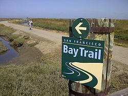
Bicycling the san francisco bay trail
The San Francisco Bay Trail is a bicycle and pedestrian trail that will eventually allow continuous travel around the shoreline of San Francisco Bay. As of 2016, 350 miles (560 km) of trail have been completed. When finished, the Bay Trail will extend over 500 miles (805 km) to link the shoreline of nine counties, passing through 47 cities and crossing seven toll bridges. It is a project of the Association of Bay Area Governments (ABAG).
Contents
- Bicycling the san francisco bay trail
- Map of San Francisco Bay Trail California USA
- San francisco bay as seen from san francisco bay trail and fort mason california usa
- Trail Route
- History
- San Francisco Bay Shoreline Guide
- San Francisco Bay Trail Maps
- The Bay Trail Plan
- References
Map of San Francisco Bay Trail, California, USA
The Bay Trail is a collaboration between elected officials, government agencies, private companies, non-profit organizations, advocacy groups and the public to increase access to the edge of the bay. It provides recreational opportunities for hikers and bicyclists; offers a setting for wildlife viewing and environmental education; and serves as a bicycle transportation corridor. The Bay Trail provides access to points of historic, natural and cultural interest, and to numerous recreational areas, including over 130 parks. The Bay Trail consists of paved paths, gravel trails, bike lanes or sidewalks.
San francisco bay as seen from san francisco bay trail and fort mason california usa
Trail Route
The Bay Trail is an interconnected trail system that links parks, open spaces, points of interest, and communities on or near the bay shoreline. It will not only encircle the Bay but will also provide access inland to open spaces and preserves, streams, and the Bay Area Ridge Trail, which forms the second of two concentric rings around the bay.
Sections of the Bay Trail exist in all nine Bay Area counties. The longest continuous segments include 26 miles (41 km) primarily on gravel levees between East Palo Alto and San Jose in Santa Clara County; 25 miles (40 km) in San Mateo County between Millbrae and San Carlos; 17 miles (27 km) in central Alameda County from San Leandro to Hayward; and 15 miles (24 km) along the shoreline and on city streets through Richmond in Contra Costa County. The northernmost trail section passes through San Pablo Bay National Wildlife Refuge.
Bicycle and pedestrian pathways exist on five Bay Area toll bridges: Golden Gate Bridge, Carquinez Bridge, Benicia-Martinez Bridge, Dumbarton Bridge and the East Span of the Bay Bridge. A complete connection on the Bay Bridge East Span between Oakland and Yerba Buena Island is scheduled to open in September 2016. A 5-year pilot program will open the Richmond-San Rafael Bridge to bicyclists and pedestrians in 2017.
History
The idea for the Bay Trail was launched in the Fall of 1986, when Senator Bill Lockyer of Hayward was having lunch with a local editor in a waterfront restaurant. The end-of-session legislative frenzy was over, and Senator Lockyer was in a reflective mood. “Let me try this idea out on you,” he said to his companion. “What if we tried to develop a pedestrian and bicycle path around the bay, with access to the shoreline?” His luncheon partner applauded the idea and urged the senator to pursue it. The outcome was Senate Bill 100. Coauthored by all Bay Area legislators, the bill passed. It defined parameters of the planning process, designated the Association of Bay Area Governments (ABAG) as the lead agency, and provided $300,000 for the preparation of a Bay Trail Plan by July 1, 1989. The Bay Trail Plan, adopted by ABAG, shows a network of trails that meander and loop along the shore, connecting all nine surrounding counties and crossing the region’s toll bridges.
San Francisco Bay Shoreline Guide
The San Francisco Bay Shoreline Guide was revised in 2012. It provides information about the natural and cultural history of San Francisco Bay and includes maps for 325 miles of the shoreline Bay Trail open to the public. Published by University of California Press for the California Coastal Conservancy.
San Francisco Bay Trail Maps
The San Francisco Bay Trail maps were released in May 2013 and updated in early 2016. The box set of 25 cards and a large fold-out map provide detailed information about the trail and points of interest along its route. Production of the maps was funded in part by the California Coastal Conservancy.
The Bay Trail Plan
The San Francisco Bay Trail Plan: A Recreational Ring Around San Francisco Bay was published in 1989 by the Association of Bay Area Governments. The plan includes the trail alignment, project goals, policies and implementation strategies for the Bay Trail.