
Type Special district Website www.ebparks.org Phone +1 888-327-2757 | Created 1934 Area 485.6 km² | |
 | ||
Address Royal Ridge Ct, Alamo, CA 94507, USA Similar Tilden Regional Park, Del Valle Regional Park, Black Diamond Mines Re, Coyote Hills Regional, Lake Chabot Regional Profiles | ||
East bay regional park district lifeguard recruitment
The East Bay Regional Park District (EBRPD) is a special district operating in Alameda County and Contra Costa County, California, within the East Bay area of the San Francisco Bay Area. It maintains and operates a system of regional parks which is the largest urban regional park district in the United States. The administrative office is located in Oakland.
Contents
- East bay regional park district lifeguard recruitment
- Camp arroyo east bay regional park district
- History
- Notable parks
- District Trails
- Vargas Plateau Regional Park
- Open space Land banks
- Hanson Hills property
- Roddy Ranch parcel
- Dainty Ranch Parcel
- Mollar Ranch parcel
- Wildcat Canyon addition
- Eddies Flat acquisition Brushy Peak Regional Preserve
- Public safety and support organization
- Lifeguards
- Aquatic Manager
- Program Lieutenant
- References
As of 2015, EBRPD spans 120,000 acres (49,000 ha) with 65 parks and over 1,200 miles (1,900 km) of trails. Some of these parks are wilderness areas; others include a variety of visitor attractions, with opportunities for swimming, boating and camping. The trails are frequently used for non-motorized transportation such as biking, hiking, and horse riding. Nearly 150 miles (241 km) of paved trails through urban areas link the parks together.
Camp arroyo east bay regional park district
History
The EBRPD was founded in 1934, and acquired its first land two years later, when the East Bay Municipal Utility District sold 2,166 acres (877 ha) of its surplus land. The founders of the district included Robert Sibley, a hiking enthusiast, Hollis Thompson, then Berkeley City Manager, and Charles Lee Tilden, among others. William Penn Mott, Jr. served as director of the agency from 1962 to 1967, and oversaw a doubling of the system's acreage from 10,500 to 22,000.
In June 2013, EBRPD purchased a 1,900 acres (770 ha) tract of land formerly known as Roddy Ranch in east Contra Costa County. The tract lies south of Antioch and west of Brentwood.The cost was reported as $14.24 million. Funding will also be provided by California Wildlife Conservation Board and an unidentified private foundation. The acquisition does not include Roddy Ranch Golf Club or about 240 acres of privately owned land inside the project boundary. The East Contra Costa County Habitat Conservancy will install gates, fencing and signs around the tract in the coming year, while the sale is in escrow. The new area will likely be named Deer Valley Regional Park.
In 2016, Vargas Plateau Regional Park in Fremont was the first park ever to have been shut down as the result of legal action in the more than 80-year history of EBRPD. During 2014, EBRPD cut park hours on a temporary and interim basis to reduce public access to Mission Peak in Fremont, using a media strategy designed by political consultant George Manross.[1][2]
Notable parks
The parks administered by the EBRPD vary greatly in size and character. Particularly notable are the string of parks along the Berkeley Hills above and east of both Berkeley and Oakland, including Wildcat Canyon Regional Park, Tilden Regional Park, Robert Sibley Volcanic Regional Preserve, Huckleberry Botanic Regional Preserve, and Redwood Regional Park.
There are also bay shore parks such as the Point Pinole Regional Shoreline north of Richmond, the Coyote Hills Regional Park near Fremont, the Martin Luther King Jr. Regional Shoreline on San Leandro Bay, and the Oyster Bay Regional Shoreline south of the Oakland International Airport.
The district also includes a former farm, a former coal mine, an extinct volcano, and one of the biggest dog-walking parks in the country. Redwood Regional Park contains the largest remaining natural stand of coast redwood in the East Bay.
District Trails
Vargas Plateau Regional Park
Around 1995, EBRPD acquired 1,200 acres (490 ha) of the Vargas Plateau in Fremont, with 1.5 miles (2.4 km) of the Bay Area Ridge Trail and 3 miles (4.8 km) of other trails. Subsequently, park use was pushed back. As of 2007, the opening was expected by 2010. In 2010, EBRPD directors were expecting it would open soon. In 2011, EBRPD put the start in 2012. As of January 2015, EBRPD pointed to late 2015; while as of May 2015, the district pointed to spring 2016.
A 2012 settlement agreement between EBRPD and the owners of two large nearby ranches required the construction of improvements to park access roads. EBRPD and the city of Fremont agreed in 2013 to undertake them jointly, using $260,000 of funding by EBRPD and performed by the city. The park opened on May 5, 2016.
However the park was closed by a court-issued preliminary injunction on July 13, 2016. The court found that the park district “did not complete the improvements required by the settlement agreement prior to opening,” which had “very specific road widening requirements.” The order applied to access by motor vehicles, as well as to access by non-motorized users for hiking, bicycling and horse riding, with immediate effect. “The park could remain closed for months or years,” until the improvements are completed.
Open space (Land banks)
One quarter of the District is designated as “land banks,” with no public access. The conversion of that open space to public use as regional parks has no fixed time line, and may span decades. Some parcels will never be converted.
Hanson Hills property
EBRPD announced in September 2016 that it had finalized the purchase of Template:76 of ranch land east of Mount Diablo near Antioch and Brentwood. The tract was identified only as the Hanson Hills property, which had previously been bought by the Save Mount Diablo conservation group. EBRPD reported that it had paid $730,000 for this property, which it intends to include in the Deer Valley Regional Park. The East Contra Costa County Habitat Conservancy contributed $547,000 to the purchase, and the remainder was supplied from the regional park Measure WW bonds approved by East Bay voters. Deer Valley Regional Park remains in Land Bank status and is closed to the public.
Roddy Ranch parcel
In 2013, EBRPD began acquiring Roddy Ranch a 1,900 acres (770 ha) additional tract in east Contra Costa County. The new acquisition will create a nearly continuous offer zone of undeveloped land in eastern Contra Costa County from Black Diamond Mines Regional Park to Marsh Creek.
Dainty Ranch Parcel
In 2013, EBRPD announced plans to acquire 1,000 acres (4.0 km2) of grazing land southwest of the Roddy Ranch tract for $5 million. It will provide hiking and recreation services, and protect habitat for rare species such as the California red-legged frog. The combined Dainty and Roddy tracts will form the future Deer Valley Regional Park near Antioch and Brentwood.
James Ball Dainty, a rancher and coal miner, acquired Dainty Ranch in 1872.
Mollar Ranch parcel
Antioch Unified School District agreed to sell a 192-acre tract known as Mollar Ranch to EBRPD. The tract adjoins the Black Diamond Mines Regional Preserve on Somerville Road in Antioch, California. EBRPD plans to use the property to create a northern entrance to the preserve. The price agreed upon is $305,000. Funding is expected to come from the California Wildlife Protection Act and East Bay Regional Parks Measure WW funds.
Wildcat Canyon addition
EBRPD announced on February 17, 2014 that it had acquired 362 acres (146 ha) of woodland on the east side of Wildcat Canyon Regional Park, which will be added to the existing park. The property is hilly with a mixture of laurels, oaks and native grasses. Fauna include mountain lions, coyotes, deer and hawks. The property had been owned by a developer who had intended to build 36 houses on it, before the recent collapse of real estate prices.
Eddie's Flat acquisition (Brushy Peak Regional Preserve)
On April 3, 2014, two conservation groups, Center for Biological Diversity and the Alameda Creek Alliance, announced the acquisition of a 79 acres (32 ha) land parcel known as "Eddie's Flat, adjacent to the western boundary of Brushy Peak Regional Preserve.
Public safety and support organization
The district maintains a police department and a fire department.
A volunteer organization that supports the work of EBRPD, the Regional Parks Foundation raises funds for the improvement of the parks. The EBRPD is a member of the Bay Area Open Space Council.
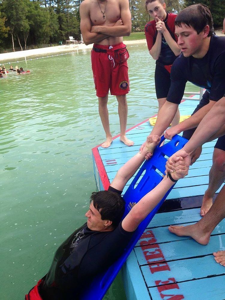
Lifeguards
East Bay Lifeguards can work at eleven different facilities.
Aquatic Manager
General Function
.Oversee 11 open water, lagoons, and pools within Alameda and Contra Costa counties.
The Aquatic Manager reports back to the Chief the East Bay Regional Park District Fire Department.
Program Lieutenant
General Function
To Assist in planning, developing, conducting and overseeing a wide range of lifeguard training, including emergency medical services, water safety, and lifeguard operations. To development and administration of aquatic recreation programs and promotional efforts. The job also entails supervising and evaluating aquatic programs staff.
The Program Lieutenant reports to the North Captain.