
 | ||
The Geography of South India comprises the diverse topological and climatic patterns of South India. South India is a peninsula in the shape of a vast inverted triangle, bounded on the west by the Arabian Sea, on the east by the Bay of Bengal and on the north by the Vindhya and Satpura ranges. The line created by the Narmada River and Mahanadi river is the traditional boundary between northern and southern India. Technically all Indian territories below the 20th Parallel.
Contents
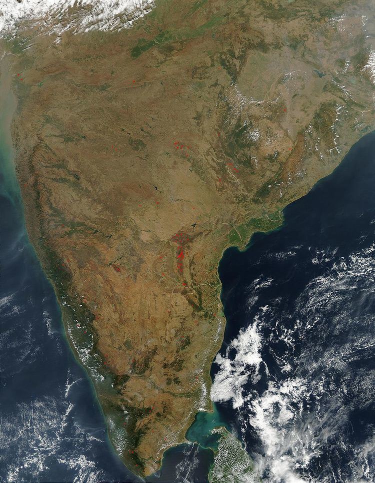
Map of India
The Satpura ranges define the northern spur of the Deccan plateau, one of the main geographic features of South India. The Western Ghats, along the western coast, mark another boundary of the plateau. The narrow strip of verdant land between the Western Ghats and the Arabian Sea is the Konkan region; the term encompasses the area south of the Narmada as far as Goa.
The Western Ghats continue south, forming the Malnad (Canara) region along the Karnataka coast, and terminate at the Nilgiri mountains, an inward (easterly) extension of the Western Ghats. The Nilgiris run in a crescent approximately along the borders of Tamil Nadu with northern Kerala and Karnataka, encompassing the Palakkad and Wayanad hills, and the Satyamangalam ranges, and extending on to the relatively low-lying hills of the Eastern Ghats, on the western portion of the Tamil Nadu–Andhra Pradesh border. The Tirupati and Anaimalai hills form part of this range.
The Deccan plateau, covering the major portion of the states of Maharashtra, Karnataka and Tamil Nadu, is the vast elevated region bound by the C-shape defined by all these mountain ranges. No major elevations border the plateau to the east, and it slopes gently from the Western Ghats to the eastern coast.
Geological development
India is entirely contained on the Indian Plate, a major tectonic plate that was formed when it split off from the ancient continent Gondwanaland. About 90 million years ago, during the late Cretaceous Period, the Indian Plate began moving north at about 15 cm/yr (6 in/yr).
The vast volcanic basalt beds of the Deccan were laid down in the massive Deccan Traps eruption, which occurred towards the end of the Cretaceous period, between 67 and 66 million years ago. Some paleontologists speculate that this eruption may have accelerated the extinction of the dinosaurs. Layer after layer was formed by the volcanic activity that lasted many thousands of years, and when the volcanoes became extinct, they left a region of highlands with typically vast stretches of flat areas on top like a table. Hence it is also known as Table Top. The volcanic hotspot that produced the Deccan traps is hypothesized to lie under the present day island of Réunion in the Indian Ocean.
Climate
The region has a very tropical climate with the monsoons playing a major part. The southwest monsoon accounts for most of the rainfall in the region and much of it falls from about June to October. Tamil Nadu and southeast Andhra Pradesh receive rains from the northeast monsoon from about November to February. Much of Andhra Pradesh and Karnataka has a distinct dry season from about October - May when there is not much rainfall. This region also experiences cooler nights from October to March while the days are pleasantly warm. In the northern parts of the region temperatures can fall below 10 degrees Celsius on occasions at night during this time. Days are very hot from March to June when temps can go over 40 degrees.
Regions
The five states of South India generally follow linguistic boundaries. In addition to these linguistic regions, South India has a number of overlapping traditional geographic regions. Some of these regions are:
The low-lying coral islands of Lakshadweep are off the south-western coast of India. Sri Lanka lies off the south-eastern coast, separated from India by the Palk Strait and the chain of low sandbars and islands known as Rama's Bridge. The Andaman and Nicobar islands lie far off the eastern coast of India, near the Tenasserim coast of Burma. The southernmost tip of mainland India is at Kanyakumari (Cape Comorin) on the Indian Ocean.
Water bodies
Rivers of South India are dependent on the monsoons and shrink during the dry season.The line created by the Narmada River and Mahanadi river is the traditional boundary between northern and southern India.The Narmada flows westwards in the depression between the Vindhya and Satpura ranges.The plateau is watered by the east flowing Godavari and Krishna rivers. The other major rivers of the Deccan plateau are the Pennar and the Tungabhadra, a major tributary of the Krishna.
The river Kaveri rises in the Western Ghats, in the Kodagu district of Karnataka and flows through the fertile Mandya, Mysore, Hassan regions before entering Tamil Nadu, where it forms an extensive and fertile delta on the east coast. The three major river deltas of South India, the Kaveri, the Godavari and the Krishna, are located along the Bay of Bengal. These areas constitute the rice bowls of South India. Rivers that flow westward, from the mountains to the Arabian Sea, include the Periyar River, Netravati River, Mandovi and Tapti River (or Tapi) rivers, and the Narmada at the northern edge of the region.
Flora and fauna
There is a large number and wide diversity of plants and animals in South India, resulting from its varied climates and geography. Tropical moist forests are found along the Arabian Sea coast and the Western Ghats. The Malabar Coast moist forests are found on the coastal plains. The South Western Ghats moist deciduous forests are found at intermediate elevations. The southern Western Ghats have high altitude rain forests called the South Western Ghats montane rain forests. The Western Ghats are a biodiversity hotspot.
Scrub lands, including the Deccan thorn scrub forests, are common in the interior Deccan plateau. Some of India's famous protected areas are found in South India. These include Project Tiger reserves Periyar National Park, Kalakad - Mundanthurai and Nagarjunsagar-Srisailam Tiger Reserve. Important ecological regions of South India are the Nilgiri Biosphere Reserve, located at the conjunction of the borders of Karnataka, Kerala and Tamil Nadu in the Nilgiri Hills including Mudumalai National Park, Bandipur National Park, Nagarhole National Park Silent Valley National Park, Wayanad Wildlife Sanctuary and Sathyamangalam Wildlife Sanctuary and the Anamalai Hills including the Eravikulam National Park, Chinnar Wildlife Sanctuary, Parambikulam Wildlife Sanctuary and the adjacent The Indira Gandhi Wildlife Sanctuary and National Park of the Western Ghats. Important bird sanctuaries including Ranganathittu Bird Sanctuary, Kumarakom Bird Sanctuary, Nelapattu and Pulicat Sanctuary are home to numerous migratory and local birds. Other protected ecological sites include the backwaters like the Pulicat Lake in Andhra Pradesh, Pitchavaram in Tamil Nadu and the famed backwaters of Kerala formed by the Vembanad Lake, the Ashtamudi Lake and the Kayamkulam Lake.