
Vehicle registration AP-21 Area 17,658 km² Tehsil 54 | Tehsils 54 Major highways AH43, NH44 Literacy 61.1% | |
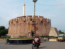 | ||
Points of interest Belum Caves, Mallikarjuna Jyotirlinga, Orvakal Rock Garden, Yeguva Sri Ahobila Narasimh, Konda Reddy Fort Destinations | ||
Kurnool District is a district in the state of Andhra Pradesh, India, located in the west-central part of the state and is bounded by Mahabubnagar district of Telangana in the north, Raichur district of Karnataka in the northwest, Bellary district of Karnataka in the west, Ananthapur district in the south, YSR Kadapa district in the South East and Prakasham district in the east. The city of Kurnool is the headquarters of the district. It has a population of 4,053,463 of which 28.35% were urban as of 2011. It occupies 10th and 2nd place in terms of area in Largest Districts of India and Andhra Pradesh respectively, accounting for 17,658 square kilometres (6,818 sq mi) and 53rd place in terms of Population in India.
Contents
- Map of Kurnool Andhra Pradesh
- Palaeolothic era
- Buddhism and Jainism
- Modern era
- Geography
- Demographics
- Household indicators
- Divisions
- Mandals
- Transport
- Education
- References
Map of Kurnool, Andhra Pradesh
Palaeolothic era
The Ketavaram rock paintings are dated back to the Paleolithic era (located at a distance of 18 km (11 mi) from Kurnool). Also the Jurreru Valley, Katavani Kunta and Yaganti in Kurnool District have some important rock art's and painting's in their vicinity, may be dated back to 35,000 to 40,000 years ago.
Buddhism and Jainism
Belum Caves are geologically and historically important caves in the district. There are indications that Jain's and Buddhist monks were occupying these caves centuries ago. Many Buddhists relics were found inside the caves. These relics are now housed in Museum at Ananthapur.
Archaeological survey of India (ASI) also found remnants of vessels, etc. of pre-Buddhist era and has dated the remnants of vessels found in the caves to 4500 BC.
Modern era
Neelam Sanjeeva Reddy (Ananthapur District) was elected from the Dhone assembly constituency in 1962 general elections and became the Chief Minister of AP. Again in 1977 general elections to the Lok Sabha, he won from the Nandyal Parliamentary constituency and became the speaker of the Lok Sabha. However he resigned and became the 6th President of the Republic of India. In 1970, part of Kurnool district was split off to become part of Prakasam district.
Kurnool District is currently a part of the Red Corridor.
Geography
Kurnool district occupies an area of approximately 17,658 square kilometres (6,818 sq mi), comparatively equivalent to New Caledonia.
The village of Ternekal lies within this region.
Kurnool is surrounded by districts of Mahbubnagar district of Telangana to the north, Anantapur sitrict, Kadapa district to south, Praksam district to east and Bellary of Karnataka to the west.
Demographics
According to the 2011 census Kurnool district has a population of 4,046,601, roughly equal to the nation of Liberia or the US state of Oregon. This gives it a ranking of 54th in India (out of a total of 640). The district has a population density of 229 inhabitants per square kilometre (590/sq mi) . Its population growth rate over the decade 2001-2011 was 14.65%. Kurnool has a sex ratio of 984 females for every 1000 males, and a literacy rate of 61.13%.
Household indicators
In 2007–2008 the International Institute for Population Sciences interviewed 1247 households in 38 villages across the district. They found that 94% had access to electricity, 89.7% had drinking water, 34.6% toilet facilities, and 51.6% lived in a pucca (permanent) home. 30.6% of girls wed before the legal age of 18 and 85.1% of interviewees carried a BPL card.
Divisions
Kurnool District has 3 Revenue Divisions viz., Kurnool, Nandyal, Adoni divisions. The district has 54 mandals and 53 Panchayat Samitis (Blocks) under these revenue divisions. It also has a Municipal Corporation of Kurnool and 4 municipalities namely, Nandyal, Adoni, Yemmiganur and Dhone. There are 899 gram panchayats that include 7 notified and 862 non-notified, alongside 920 revenue villages and 615 hamlets.
Mandals
The mandals are listed with respect to their revenue divisions in the following table:
Kurnool District has 3 Revenue Divisions viz., Kurnool, Nandyal, Adoni divisions.
Source:
Transport
The total of core road network of the district is 1,162.20 km (722.16 mi). It includes, 504.48 km (313.47 mi) of existing and a proposed length of 657.720 km (408.688 mi).
Education
The primary and secondary school education is imparted by government, aided and private schools, under the School Education Department of the state. As per the school information report for the academic year 2015-16, there are a total of 4,179 schools. They include, 78 government, 2,398 mandal and zilla parishads, 1 residential, 1,355 private, 33 model, 53 Kasturba Gandhi Balika Vidyalaya (KGBV), 140 municipal and 121 other types of schools. The total number of students enrolled in primary, upper primary and high schools of the district are 631,740.