
Country India Time zone IST (UTC+5:30) | State Karnataka Area 8,441 km² | |
 | ||
Vehicle registration KA-19, KA-20, KA-21, KA-62, KL-14 | ||
South canara trip jai
South Canara was a district of the Madras Presidency of British India, located at 13.00°N 75.40°E / 13.00; 75.40. It covered the areas of the present-day districts of Dakshina Kannada and Udupi of Karnataka and the Kasaragod District of Kerala. The district was one of the most heterogeneous of Madras Presidency with Tulu, Malayalam, Kannada, Konkani and Beary being the principal languages spoken. It was succeeded by Dakshina Kannada in 1947.
Contents
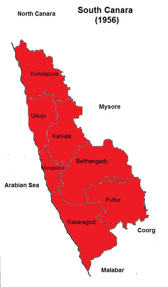
South Kanara was annexed by the British East India Company following the defeat of Tipu Sultan in the Fourth Mysore War 1799 and along with North Kanara formed the district of Kanara in the Madras Presidency. In 1859, Kanara was split into two districts, North and South. North Kanara was transferred to the Bombay Presidency, and South was retained by Madras. Mangalore was the administrative headquarters of the district. The district covered an area of 10,410 square kilometres (4,021 sq mi).
Mangalore south canara
Taluks
The district was divided into six taluks:
Administration
The district was administered by a District Collector. For purpose of convenience, the district was divided into three sub-divisions:
The district had two municipalities, those of Mangalore and Udupi.
Demographics
South Kanara had a total population of 1,134,713 in 1901, of whom 81 percent were Hindus, 11 percent Muslim and 7 percent Christian. The most widely spoken language was Tulu which was the mother tongue of 44 percent of the population, followed by Kannada which formed the mother tongue of 23 percent each of the population. Around 19 percent of the total population spoke Konkani. Around 09 percent of the population speaks Beary Bashe as their mother tongue. In 1901, South Kanara had a density of 109 inhabitants per square kilometre (282/sq mi).
The 1908 Imperial Gazetteer of India lists South Canara, along with the Thanjavur and Ganjam districts, as the three districts of the Madras Presidency where Brahmins are most numerous.
The majority of the people were Billavas, Bunts. There were more Brahmins (12% of the population) in South Kanara than any other district of the Madras Presidency making South Kanara, along with Tanjore and Ganjam as one of the three districts of the province where Brahmins were most numerous.
The people who first settled here were called Tuluvas, predominantly Bunts, and Billavas. The Brahmins who settled first belonged chiefly to the Sthanika and thus they were called as Tulu Brahmins. Others were Shivalli, Saraswat, Havyaka, Kotaha sub-sections, Mogaveera and Mahars, the hill-tribes (Koragas).