
Listing Territory high point Prominence 661 m Parent range Brindabella Range | Elevation 1,912 m Easiest route Hiking | |
 | ||
Mountain range Brindabella Range, Great Dividing Range Similar Mount Gingera, Mount Stromlo, Mount Ginini, Mount Franklin, Black Mountain | ||
Climbing bimberi peak
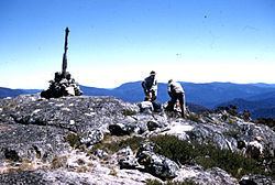
Bimberi Peak or Mount Bimberi with an elevation of 1,913 metres (6,276 ft) located within the Brindabella Ranges is the highest mountain in the Australian Capital Territory. It is located on the border between New South Wales and the ACT, the NSW portion in Kosciuszko National Park and the ACT portion in Namadgi National Park. It is accessible by bush walking trails and requires no specialised climbing skills, although there is no marked trail to the very summit. As the highest mountain in the ACT, it is a popular spot for tourists
Contents
- Climbing bimberi peak
- Map of Mount Bimberi Cotter River ACT 2611 Australia
- Australia act bimberi peak 360 panoramic view from summit
- RoutesEdit
- Vegetation and weatherEdit
- References
Map of Mount Bimberi, Cotter River ACT 2611, Australia
Australia act bimberi peak 360 panoramic view from summit
RoutesEdit
Bimberi Peak can be reached along the Australian Alps Walking Trail, from the east through the ACT, or from the west through NSW, approximately 40 kilometres (25 mi) north northwest of Adaminaby that ascends the southern ridge.
When climbing Bimberi from the west, a dirt road, that is closed during winter, leads to a locked gate at Currango Plain, called Pockets Saddle Road Gate, a gain of 650 metres (2,130 ft). The trailhead commences at an elevation of 1,270 metres (4,170 ft) as an easy two–hour walk 3.3 kilometres (2.1 mi) along a fire trail passes by Oldfields Hut and crosses several streams, before reaching a gate at Murray's Gap, an ascent of 430 metres (1,410 ft) over 4.3 kilometres (2.7 mi). From the ascent is best accessed by breaking away from the trail and hiking up the southern ridge of the summit, taking about 3–3.5 hours to climb over 2.9 kilometres (1.8 mi). Following the ridge up is the easiest way to summit, although taking a compass bearing is useful. The total distance via this route is about 10.5 kilometres (6.5 mi). There is a large surveyors mark at the summit.
Vegetation and weatherEdit
The top of Bimberi Peak is above the tree line. Strong winds blow across the summit. During winter Bimberi is generally covered in snow.