
Population 86,900 (2011 census) | Gazetted 12 May 1966 | |
 | ||
Location 22 km (14 mi) SSW of Canberra City Territory electorate(s) BrindabellaMurrumbidgee Weather 27°C, Wind N at 3 km/h, 38% Humidity University Canberra Institute of Technology, Tuggeranong Points of interest Lake Tuggeranong, Pine Island Reserve Restaurants Canberra Southern Cross Clu, Little Istanbul, McDonal Erindale, China Tea House, Calwell Club | ||
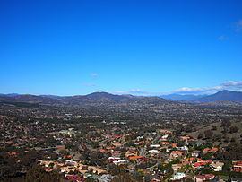
Tuggeranong lake canberra australia
The District of Tuggeranong is one of the original eighteen districts of the Australian Capital Territory used in land administration. The district is subdivided into divisions (suburbs), sections and blocks and is the southernmost town centre of Canberra, the capital city of Australia. The district comprises nineteen suburbs and occupies 117 square kilometres (45 sq mi) to the east of the Murrumbidgee River.
Contents
- Tuggeranong lake canberra australia
- Map of Tuggeranong ACT Australia
- Limelight zoofari movie festival tuggeranong
- Establishment and governance
- History
- Location and urban structure
- Demographics
- List of suburbs
- Places of note and interest
- References
Map of Tuggeranong, ACT, Australia
The name Tuggeranong is derived from a Ngunnawal expression meaning "cold place". From the earliest colonial times, the plain extending south into the centre of the present-day territory was referred to as Tuggeranong.
At the 2011 census, the population of the district was 86,900.
Limelight zoofari movie festival tuggeranong
Establishment and governance
The traditional custodians of the district are the indigenous people of the Ngunawal tribe.
Following the transfer of land from the Government of New South Wales to the Commonwealth Government in 1911, the district was established in 1966 by the Commonwealth via the gazettal of the Districts Ordinance 1966 No. 5 (Cth) which, after the enactment of the Australian Capital Territory (Self-Government) Act 1988 (Cth), became the Districts Act 1966 No. 5 (ACT). This Act was subsequently repealed by the ACT Government and the district is now administered subject to the Districts Act 2002 (ACT).
History
Cave paintings and Aboriginal artifacts discovered in the area confirm that the Tuggeranong region has been occupied by the original inhabitants, the Ngunnawal people, for over 21,000 years.
The first Europeans arrived in the Canberra region in 1820 and a year later, a third expedition led by Charles Throsby reached the Murrumbidgee River near the present-day Pine Island and the valley now occupied by the Tuggeranong district. In 1823 Joseph Wild was employed by Brigade Major John Ovens and Captain Mark Currie to guide them to the Murrumbidgee. They travelled south along the river and named the area now known as Tuggeranong Isabella's Plain in honour of Governor Brisbane's infant daughter. Unable to cross the river near the current site of Tharwa, they continued on to the Monaro Plains.
The last expedition in the region was undertaken by Allan Cunningham in 1824. Cunningham's reports verified that the region was suitable for grazing, and the settlement of the Limestone Plains followed immediately thereafter.
In 1828, the bushranger John Tennant, known as the 'Terror of Argyle', was captured by James Ainslie and a party of others near the Murrumbidgee River in Tuggeranong. Tennant had been a convict assigned to Joshua John Moore at Canberry, a property in the present day inner north Canberra. Mount Tennent, behind Tharwa, is named after the bushranger (note the difference in spelling).
The first authorised settler was James Murdoch. In 1824 he was offered a land grant on a small plain known by the natives as 'Togranong' meaning 'cold plains'. He took up the grant in 1827. Lanyon station was established in 1835 and originally owned by James Wright, his brother William and John Lanyon. Wright bought the property from Lanyon, who had only remained in Australia for three years. In 1838, Wright commenced the building of the homestead, which he named after his partner, Lanyon. The homestead was built with the strength of a fort to withstand the attacks of bushrangers. Wright sold to the Cunningham family in 1847. In 1835 Thomas Macquoid, then Sheriff of the New South Wales Supreme Court, bought Tuggeranong station then known as Waniassa property (sic). The rural depression of 1840 hit hard and Macquoid committed suicide, fearing bankruptcy when he lost a civil suit brought by one William Henry Barnes. His son took over the estate and creditors allowed him to continue to operate it until it was sold by the Macquoid family in 1858 to the Cunningham family, owners of the neighbouring Lanyon property. They renamed Waniassa to Tuggranong. The whole area was part of the Tuggeranong parish in the late nineteenth century. Tuggranong homestead was rebuilt by the Cunningham family in 1908. In 1917 it was resumed by the Commonwealth Government for military purposes. The Cunningham family remained at Lanyon until 1926. Charles Bean, together with his staff, wrote the first two volumes of the twelve volume official history of Australia's involvement in World War I at the homestead from 1919 to 1925. The Tuggeranong property was leased as a grazing property by the McCormack family from 1927 to 1976.
In 1973, the third of the new towns planned for Canberra was inaugurated at Tuggeranong on 21 February. It was originally planned to house between 180,000 to 220,000 people. Planning for the new town had begun in 1969. The first families moved into the suburb of Kambah in 1974. The fifth Canberra fire station opened at Kambah in 1979 to service the new developing satellite city.
Location and urban structure
The district is a set of contiguous residential suburbs consolidated around Lake Tuggeranong, in addition to vast pastoral leases that extend south of the suburbs of Banks, Conder and Gordon. The boundaries of the district are constrained by the Murrumbidgee River to the west, the border with the state of New South Wales to the south and east, and pastoral leases that mark the district's boundary to the north, including the remnants of the Tuggeranong Homestead, and to the north-west.
Lake Tuggeranong was created in 1987 by the construction of a dam on a tributary of the Murrumbidgee River. On the edge of the lake are a number of community facilities, including Lake Tuggeranong College, a school catering to years 11 and 12 (16 – 18 years old); a library, which is part of the ACT Library and Information Services, a community centre, and the Tuggeranong Arts Centre.
The Tuggeranong Town Centre is to the west of the lake. It includes a major shopping centre, known as the Centro Tuggeranong Hyperdome (referring to the architectural use of semi-opaque domes in the roof); managed, developed and part owned by Vicinity Centres. It is surrounded by offices of the Australian and ACT governments, and a light industrial area.
A further heavy industrial area is located in the suburb of Hume that lies partly in the districts of both Tuggeranong and Jerrabomberra.
Demographics
At the 2011 census, there were 86,900 people in the Tuggeranong district, of these 49.3 per cent were male and 50.7 per cent were female. Aboriginal and Torres Strait Islander people made up 2.1 per cent of the population, which was lower than the national average, but higher than the territory average. The median age of people in the Tuggeranong district was 35 years, which was marginally lower than the national median of 37 years. Children aged 0–14 years made up 20.5 per cent of the population and people aged 65 years and over made up 7.9 per cent of the population. Of people in the area aged 15 years and over, 50.1 per cent were married and 11.9 per cent were either divorced or separated.
Population growth in the Tuggeranong district between the 2001 census and the 2006 census was 0.85 per cent; and in the subsequent five years to the 2011 census, the population decreased by 0.25 per cent. When compared with total population growth of Australia for the same periods, being 5.78 per cent and 8.32 per cent respectively, population growth in Tuggeranong district was significantly lower than the national average. The median weekly income for residents within the Tuggeranong district was significantly higher than the national average, and slightly lower than the territory average.
At the 2011 census, the proportion of residents in the Tuggeranong district who stated their ancestry as Australian or Anglo-Saxon exceeded 71 per cent of all residents (national average was 65.2 per cent). In excess of 53 per cent of all residents in the Tuggeranong district nominated a religious affiliation with Christianity at the 2011 census, which was marginally higher than the national average of 50.2 per cent. Meanwhile, as at the census date, compared to the national average, households in the Tuggeranong district had a lower than average proportion (16.3 per cent) where two or more languages are spoken (national average was 20.4 per cent); and a higher proportion (84.3 per cent) where English only was spoken at home (national average was 76.8 per cent).
List of suburbs
A 1975 map of the proposed suburb names in Tuggeranong shows that many more suburbs were planned, and that the eventual layout of Tuggeranong is very different from what the planners were thinking. It was proposed that residential development would occur west of the Murrumbidigee River, a corridor that is subsequently free of urban development. Suburbs planned (but not built, or had their names changed) were: