
Existed: 1926 – present Constructed 1926 | Length 1,994 km | |
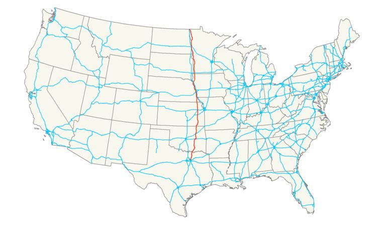 | ||
U.S. Route 75 is a north–south U.S. Highway. The highway's northern terminus is in Noyes, Minnesota, at the Canada–US border, where it once continued as Manitoba Highway 75 on the other side of the now-closed border crossing. Its southern terminus is at Interstate 30 and Interstate 45 in Dallas, where it is known as North Central Expressway.
Contents
- Map of US 75 United States
- Texas
- Oklahoma
- Kansas
- Nebraska
- Iowa
- Minnesota
- Nebraska Iowa
- Major intersections
- References
Map of US-75, United States
U.S. 75 was a border-to-border route, from Canada to the Gulf of Mexico at Galveston, Texas. However, the entire segment south of Dallas has been decommissioned in favor of Interstate 45, a cutoff section of town-to-town surface road having become State Highway 75.
Texas
The first freeway in Texas was a several-mile stretch of US 75 (now I-45)--The Gulf Freeway, opened to Houston traffic on October 1, 1948. The stretch of US 75 between Interstate 30 and the Oklahoma state line has exits numbered consecutively from 1 to 75 (with occasional A and B designations), excluding 9-19. All other Texas freeways that have exit numbers are coordinated with mile markers.
From Denison north to the Oklahoma border, US 75 is concurrent to U.S. Route 69.
Oklahoma
US-75 remains concurrent to US-69 from the Texas border north to Atoka. While US-69 continues to the northeast as a multilane highway, US-75 turns north to serve several small communities between Atoka and Henryetta. Through travellers bypass this segment of US-75 via US-69 and the Indian Nation Turnpike, where the speed limit is 75 miles per hour (121 km/h).
From Henryetta through Tulsa and on through Bartlesville to the Kansas State Line, US-75 is once again a multilane highway.
In the early 1990s, some portions of US-75 in Oklahoma were slated to become part of the Interstate Highway System. The 1991 Intermodal Surface Transportation Efficiency Act (ISTEA) states that "upon the request of the Oklahoma State highway agency, the Secretary shall designate the portion of United States Route 69 from the Oklahoma-Texas State line to Checotah in the State of Oklahoma as a part of the Interstate System." This would have created an Interstate route from Interstate 40 south to the Texas line, including the portion of US-75 co-signed with US-69 south of Atoka. The legislation was unclear whether the route would enter Texas to connect with or become an extension of Interstate 45. A current plan is to construct a new segment of the Oklahoma Turnpike along the US-69 corridor to bring it to corridor standards.
Kansas
A major north–south artery in Kansas, US-75 enters the state at Caney. It passes through Independence and crosses Interstate 35 south of Olivet at the BETO Junction. From I-35 to Melvern Lake, US-75 is a Super-2 highway, with controlled access interchanges at Township Road, K-278, and K-31 southbound. From Melvern Lake to just north of Lyndon, US-75 and K-31 share a long concurrency. At U.S. Route 56 near Scranton US-75 becomes a freeway. There is no direct access to the Kansas Turnpike from US-75, but the highway joins with Interstate 470 less than 1 mile (2 km) from 470's interchange with the turnpike. US-75 and Interstate 470 run together along the west side of Topeka to Interstate 70. US-75 turns east along Interstate 70 for about 3 miles (5 km) before exiting northbound as a freeway. This freeway segment runs to Elmont, then becomes an expressway to Holton. The remainder of US-75 in Kansas is two lanes. The highway exits the state north of Sabetha.
There was a US-75 Alternate in Topeka, Kansas. It was on Topeka Boulevard and was the route US-75 originally took through Topeka.
Nebraska
U.S. 75 enters Nebraska south of Dawson. From Nebraska City northward, it closely parallels the Missouri River. A brief section which serves as a bypass for Nebraska City is an expressway called the J. Sterling Morton Beltway. Nebraska City itself is served with Business Route U.S. 75. U.S. 75 and U.S. Route 34 overlap from Union to Plattsmouth. North of Plattsmouth, U.S. 75 becomes the Kennedy Freeway, serving as an arterial highway through Bellevue and the South Omaha neighborhood of Omaha. It follows Interstate 480 briefly through central Omaha before branching off as the North Omaha Freeway. From Interstate 680 northward to Nashville (3 miles south of Fort Calhoun) U.S. 75 is an expressway. North of Nashville it becomes a two-lane road again. It is briefly concurrent with U.S. Route 30 in Blair. It joins with U.S. Route 77 at Winnebago. The two highways run together until their junction with Interstate 129 and U.S. Route 20 at South Sioux City. U.S. 75 follows I-129 and U.S. 20 towards the Missouri River and Iowa.
Iowa
U.S. 75 is a major north–south artery in the northwestern corner of Iowa. It enters the state by a Missouri River crossing at Sioux City concurrent with Interstate 129 and U.S. Route 20. U.S. 75 and U.S. 20 run together on a freeway bypass around the southeast side of Sioux City before U.S. 20 turns east at Gordon Drive. U.S. 75 continues as a freeway to the Woodbury County/Plymouth County line, where it becomes an expressway. This expressway becomes a freeway bypass of Le Mars. North of Le Mars, U.S. 75 exits off the freeway bypass, which continues on as Iowa Highway 60, and turns north. U.S. 75 continues as a two-lane, undivided highway passing through Sioux Center and Rock Rapids before leaving the state north of Iowa Highway 9.
The segment from the Missouri River to LeMars is part of a larger expressway project which will eventually provide a direct connection between Sioux City and the Twin Cities region in Minnesota.
Minnesota
In Minnesota, U.S. 75 stays very close to the state's western border. It passes through few large towns. U.S. 75 enters Minnesota south of Luverne near Ash Creek and Steen, and passes though Pipestone, Canby, and Breckenridge. It is the main north–south route through Moorhead. North of Moorhead, the route turns northeast to pass through Crookston (east of Grand Forks, ND), then turns northwest towards the Red River of the North. U.S. 75 does not cross the Red River, ending instead at the Canadian border at the unincorporated community of Noyes. It is not possible to cross the border at Noyes as the port of entry closed in July 2006. Border traffic is instead directed to the nearby crossing in Pembina, North Dakota (via Minnesota State Highway 171, North Dakota Highway 59 and Interstate 29). Manitoba Highway 75 previously continued on the other side of the Noyes border crossing, but has since been re-routed by the Province of Manitoba to the Pembina crossing.
All 408 miles (657 km) of U.S. 75 in Minnesota is officially designated the Historic King of Trails, sponsored by the towns along the route. The King of Trails was in fact the historic Auto Trail name for this road before the trunk highway system was commissioned in 1920.
Legally, the Minnesota section of U.S. 75 is defined as Routes 6 and 175 in Minnesota Statutes §§ 161.114(2) and 161.115(106).
Texas
In the initial assignment of state highways in 1917, Dallas-Fort Worth and Houston were connected by a branch of State Highway 2 (the Meridian Highway), which ran via Waco and Bryan and continued on to Galveston. The more direct route followed by US 75 was not initially part of the system between Richland (connected to Dallas by SH 14) and Huntsville (connected to Houston by SH 19). This Richland-Huntsville cutoff was added by 1919 as State Highway 32, and US 75 was assigned to the alignment, as well as SH 6 north of Dallas, in 1926. The branch of SH 2, which US 75 followed between Houston and Galveston, eventually became part of SH 6, and these numbers were dropped in the 1939 renumbering.
Prior to the coming of the Interstate Highway System in the late 1950s, the only improvements to US 75 in Texas beyond building a two-lane paved roadway were in the Houston and Dallas areas. However, the highways in and near these cities included some of the first freeways in the state: the Gulf Freeway (Houston) and the Central Expressway (Dallas). When Interstate 45 was built in the 1960s, its alignment bypassed many of the towns and built-up areas between downtown Dallas and Houston. The bypassed routes retained the US 75 designation until the designation was truncated to downtown Dallas in 1987. Many of the original alignments continue to exist under other designations.
In Dallas, the route followed what is now the Good Latimer Expressway (formerly Spur 559) southeast, out of downtown, along US 175 and south along State Highway 310.
Near Ferris, Trumbull, Palmer, Ennis, and Corsicana Interstate 45 veers east to avoid the more populated areas. The old US 75 alignments through these towns, decommissioned in 1987, now carry the following designations:
Through Streetman, Fairfield, Buffalo, Centerville, Madisonville, Huntsville, New Waverly, Willis, and Conroe, US 75 followed what is now State Highway 75.
In Galveston, the alignment of State Highway 87 from 20th Street to the southern terminus Interstate 45 was also part of US 75 until its 1987 truncation.
In other cases alignments were bypassed while US 75 remained in existence; they now carry the following designations:
Oklahoma
The main line of US-75 from Beggs to Tulsa, known locally as the "Okmulgee Beeline", is a modern four-lane highway. Its original route between the two locations, 3 miles (5 km) to the west through Kiefer, was designated as Alternate US-75. Historically, US-75 met Route 66 (now State Highway 66) in Sapulpa, and the routes were co-signed into Tulsa.
Nebraska
Development of U.S. 75 in North Omaha, Nebraska was the source of much contention in when it was constructed. One state agency reports, "Construction of the North Omaha Freeway, coupled with social unrest in the 1970s, greatly impacted the North Omaha area. One neighborhood experienced a 30 percent housing loss and major increase in crime." Further, the City of Omaha refused to complete upgrades to the freeway, eliminating the possibility of achieving the Interstate 580 designation planned for it.
Nebraska-Iowa
From when the route was created in 1926 until 1984, U.S. Route 75 left Nebraska in Omaha, crossing over the Missouri River into Council Bluffs, Iowa over the Ak-Sar-Ben Bridge before 1966, and the I-480 Bridge from 1966 until 1984. U.S. 75 then followed an alignment that went through western Iowa between Council Bluffs and Sioux City. After Interstate 29 was built, U.S. 75 was eventually moved onto I-29. In 1984, U.S. 75 was rerouted into Nebraska to replace most of U.S. 73. Previously, U.S. 73 was concurrent with U.S. 75 between Dawson, Nebraska and Omaha, and occupied the current segment of U.S. 75 between Omaha and Winnebago.