
Congressional district 4th Website www.co.plymouth.ia.us Founded 1851 County seat Le Mars | Time zone Central: UTC-6/-5 Area 2,238 km² Population 24,957 (2013) Largest city Le Mars | |
 | ||
Cities Le Mars, Remsen, Akron, Hinton, Brunsville, Oyens, Merrill, Kingsley, Westfield, Struble, Craig Rivers Big Sioux River, Floyd River, Perry Creek, Elliott Creek | ||
Plymouth County is a county located in the U.S. state of Iowa. As of the 2010 census, the population was 24,986. The county seat is Le Mars. Plymouth County was named after Plymouth, Massachusetts.
Contents
- Map of Plymouth County IA USA
- History
- Geography
- Adjacent counties
- Major highways
- Airport
- 2010 census
- 2000 census
- Points of interest
- Notable natives
- Population ranking
- References
Map of Plymouth County, IA, USA
Plymouth County is part of the Sioux City, IA-NE-SD Metropolitan Statistical Area.
History
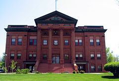
Plymouth County was formed on January 15, 1851. Settlement began in the county in 1856. In October, 1859, the first courthouse was built in Melbourne, formerly located in the southeast quarter of section 34, Plymouth Township, about five to six miles due south of Merrill. The first public school opened its doors there with 32 pupils. In 1872, the county seat was moved to Le Mars and a new courthouse and a jail were built there in 1873. The courthouse in present use was built in 1900 of red sandstone.
During the Great Depression, the farmers organized a group, which they named the Farmers Holiday Group. The goal was to keep farm products off the market until the desired price was met. A radical group among them abducted Judge Bradley from his court chamber and threatened to hang him in the front of the courthouse. Bradley was freed, but the governor ordered the national guard to Plymouth County and declared state of emergency, which meant the end of the Farmers Holiday Group.
Geography
According to the U.S. Census Bureau, the county has a total area of 864 square miles (2,240 km2), of which 863 square miles (2,240 km2) is land and 0.8 square miles (2.1 km2) (0.1%) is water. It is the fourth-largest county by area in Iowa.
Adjacent counties
Major highways
Airport
Le Mars Municipal Airport is located in Plymouth County, two nautical miles (3.7 km) southwest of the central business district of Le Mars, Iowa.
2010 census
The 2010 census recorded a population of 24,986 in the county, with a population density of 28.9337/sq mi (11.17137/km2). There were 10,550 housing units, of which 9,875 were occupied.
2000 census
As of the census of 2000, there were 24,849 people, 9,372 households, and 6,804 families residing in the county. The population density was 29 people per square mile (11/km²). There were 9,880 housing units at an average density of 11 per square mile (4/km²). The racial makeup of the county was 98.16% White, 0.29% Black or African American, 0.14% Native American, 0.27% Asian, 0.06% Pacific Islander, 0.46% from other races, and 0.62% from two or more races. 1.32% of the population were Hispanic or Latino of any race.
There were 9,372 households out of which 35.70% had children under the age of 18 living with them, 63.30% were married couples living together, 6.20% had a female householder with no husband present, and 27.40% were non-families. 24.00% of all households were made up of individuals and 12.00% had someone living alone who was 65 years of age or older. The average household size was 2.61 and the average family size was 3.12.
In the county, the population was spread out with 28.30% under the age of 18, 7.20% from 18 to 24, 26.40% from 25 to 44, 22.00% from 45 to 64, and 16.00% who were 65 years of age or older. The median age was 38 years. For every 100 females there were 98.80 males. For every 100 females age 18 and over, there were 95.70 males.
The median income for a household in the county was $41,638, and the median income for a family was $50,009. Males had a median income of $33,566 versus $22,558 for females. The per capita income for the county was $19,442. About 4.40% of families and 6.00% of the population were below the poverty line, including 6.70% of those under age 18 and 6.40% of those age 65 or over.
Points of interest
The Pappas Telecasting Tower, with a height of 603.5 metres (1,980 ft), is one of the tallest masts in the world.
Notable natives
Population ranking
The population ranking of the following table is based on the 2010 census of Plymouth County.
† county seat