
Existed: 1949 – present Constructed 1949 | Length 101 km | |
 | ||
North end: PTH 100 / Route 42 in Winnipeg | ||
Provincial Trunk Highway 75 (PTH 75, also officially known as the Lord Selkirk Highway) is the main highway from Winnipeg, Manitoba, to the Canada–U.S. border, where it connects with Interstate 29.
Contents
- Map of MB 75 Manitoba Canada
- Route description
- History
- Speed limits
- Flooding issues
- Major intersections
- References
Map of MB-75, Manitoba, Canada
Route description
The highway, which is part of Canada's National Highway System, begins at the Canada-United States border at Emerson and runs approximately 101 kilometers (63 miles) north, along on the west side of the Red River, to Winnipeg. There it connects with Pembina Highway, which forms the southern portion of Winnipeg Route 42. PTH 75 is also part of an International Mid-Continent Trade Corridor, a network of highways and rail lines that connects cities in central regions of North America.
The entire route is a 4-lane divided highway, but access is not fully controlled. Proposals do exist to upgrade the highway to an expressway or freeway standard with bypasses at Morris and St. Norbert. PTH 75 consisted of two lanes south of Morris until approximately 1992 when the current four-lane divided highway between Morris and United States border was built.
History
The PTH 75 route originated as a trail used by early settlers to travel between the Selkirk Settlement and Fort Pembina. The provincial government officially designated the road as the Lord Selkirk Highway in 1962 to commemorate this.
Prior to the numbering system, PTH 75 was the northern leg of the Jefferson Highway, also known as the Palm to Pine Highway since it ended in New Orleans.
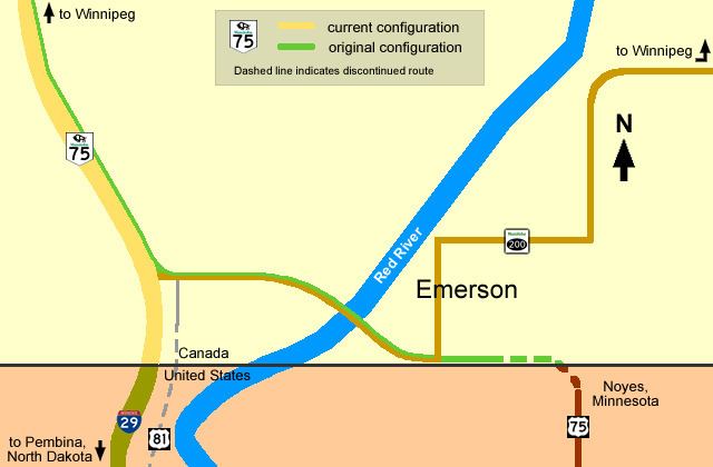
When Manitoba introduced the numbering system for highways in 1920, PTH 75 was originally numbered as Highway 14. In 1949, the government re-designated it to match U.S. Route 75 as, at that time, the Manitoba highway crossed the Red River at Emerson and connected with the U.S. 75 at the Noyes, Minnesota border crossing on the east side of the Red River. Today, PTH 14 runs west from PTH 75 to PTH 3 near Winkler.
The Canadian government closed the Emerson East border crossing in 2003 to consolidate resources; the American port of entry at Noyes followed soon after. Motorists wishing to travel US 75 must now take Interstate 29 south to North Dakota Highway 59 at Pembina, North Dakota, then east to Minnesota State Highway 171, which connects to U.S. 75. In 2012, the provincial government officially re-routed PTH 75 to extend all the way to the Pembina-Emerson Border Crossing, which eliminated PTH 29. The former PTH 75 route through Emerson is now part of Provincial Road 200.
Planning is currently underway to redesign the PTH 75 approach to the Emerson border crossing, in order to accommodate future expansion at the port of entry.
Speed limits
On February 27, 2008 the Manitoba Highway Traffic Board approved a request by the Government of Manitoba to raise the speed limit on Highway 75 in Manitoba to 110 km/h (70 mph) on most sections between Winnipeg and the US border. The speed limit change took effect on July 1, 2009, where the speed limit was raised to 110 km/h only from St. Jean Baptiste to the Canada-U.S. border. The rest of the highway is still not set to the new speed and remains at 100 km/h (60 mph), though this might change in the future.
Flooding issues
PTH 75's proximity to the flood-prone Red River causes closures of the highway during spring flooding. The town of Morris is one of the most problematic areas, as the town is forced to close off the dikes surrounding the town, thereby cutting off PTH 75. These closures have a significant impact on the trucking industry, as PTH 75 is the primary transportation route between Winnipeg and the United States. The Manitoba Trucking Association estimates the closing of the highway costs the industry $1.5 million CAD per week. The closures also have a significant impact on Morris businesses that depend on travelers passing through town. There are several solutions being considered to fix the ongoing problem, including the building of new bridges and raising of roadways along PTH 75, and the construction of a bypass for PTH 75 around Morris.
Major intersections
This is the travel route for Provincial Trunk Highway 75 (PTH 75) from south to north: