
Existed: 1926 – present KY KY 43 → Constructed 1926 | Length 571.3 km | |
 | ||
West end: US 31E / US 60 in Louisville, KY North end: US 6 / US 20 / US 322 / US 422 / SR 3 / SR 8 / SR 14 / SR 43 / SR 87 in Cleveland, OH | ||
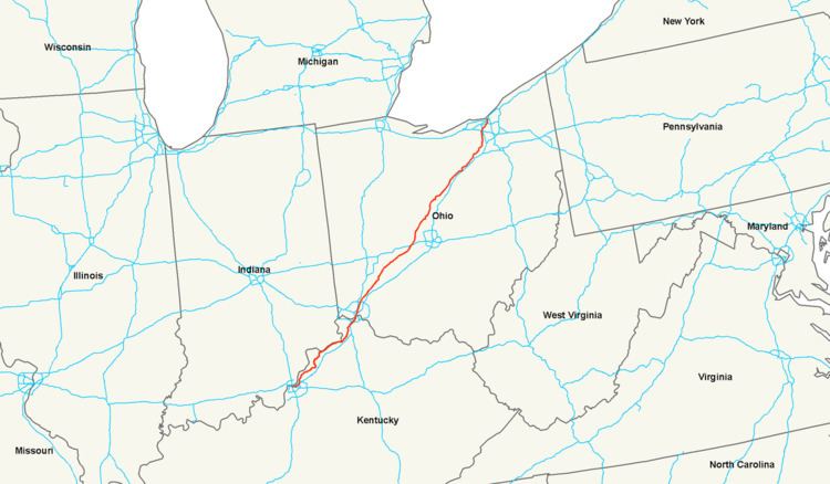
U.S. Route 42 (US 42) is an east–west United States highway that runs southwest-northeast for 355 miles (571 km) from Louisville, Kentucky to Cleveland, Ohio. The route has several names including Pearl Road from Cleveland to Medina in Northeast Ohio, Reading Road in Cincinnati, Cincinnati and Lebanon Pike in southwestern Ohio and Brownsboro Road in Louisville. Traveling east, the highway ends in downtown Cleveland, Ohio; and traveling west it ends in Louisville.
Contents
Map of US-42, United States
Interstate 71 fully supplanted US 42 as an interurban highway in the early 1960s, relegating US 42 to its current role as an ordinary town-to-town surface road. Additionally, I-71 passes through Columbus, where US 42 avoids Columbus completely. It remains intact as a route; no part of it has ever been diverted to any Interstate highway. It is not the "parent" of any US route with a related number.
In spite of its even number, US 42 is posted north-south in Ohio.
Kentucky
U.S. Route 42 starts in Louisville, Kentucky, heading northeast through Prospect on the Oldham County and Jefferson County line. From here US 42 is a two lane road passing through the northern KY hills paralleling between Interstate 71 and the Ohio River. Next, it passes through Goshen and North Oldham High School, which sits off to its north side. U.S. 42 continues through Oldham County into Trimble County. In Bedford US 42 intersects with US 421 and is concurrent through downtown. The route still heading northeast crosses into Carroll County prior to crossing the Kentucky River and entering Carrollton. US 42 follows northeast along the south bank of the Ohio River passing Markland Lock and Dam and KY 1039 Markland Dam Bridge which connects between Kentucky Speedway and Indiana. Heading east US 42 parallels the Ohio River passing through Warsaw, Gallatin County about 5 miles (8.0 km) prior to intersecting with U.S. Route 127 starting an extended concurrency. US 127 heads south toward Glencoe, Owenton, and eventually Frankfort.
From the intersection with US 127, US 42 turns away from the Ohio River bank. US 42 enters Boone County about 2.25 miles (3.62 km) prior to intersecting with the western terminus of KY 14. Continuing North US 42-127 in about 6 miles (9.7 km) intersects Beaver Road KY 338 creating a wrong-way concurrency between U.S. 127 and KY 338: when going north, drivers are traveling east on U.S. 42, north on U.S. 127, and south on Kentucky 338. This continues for less than a mile until it intersects with Richwood Pike where KY 338 splits off continuing south.
Continuing north for several miles the US 42-127 intersects with KY 536 (Mount Zion Road). Prior to KY 536 Ryle High School sits on the road's west side. Just south of Ryle, U.S. 42 turns from a two-lane country road to a five-lane road. US 42 passes through Union prior to continuing to the northeast with U.S. 127. After a couple of miles, it crosses Interstate 71/Interstate 75. Entering Florence US 42 intersects with KY 842 and KY 237. Within Florence U.S. Route 25 Dixie Highway joins in a concurrency with US 42-127 which takes on the name Dixie Highway. After crossing briefly into Elsmere, the route enters Erlanger. U.S. 42 becomes almost entirely a commercial road for the duration of its length in Erlanger. Prior to leaving Erlanger, U.S. 42 becomes narrower and more congested after it crosses KY 236.
U.S. 42 is primarily a commercial road prior to crossing under I-275 and proceeds to turn back into an almost purely residential road with a few exceptions while going north. The route intersects with KY 1303 (Turkeyfoot Road) northern terminus. The Crestview Hills town center lies just south of I-275 on the east side of the road, between Dixie Highway and Turkeyfoot Road. Dixie Heights High School is less than a mile down the road on the western side. Two intersections later US 42 is joined with KY 371 for about 500 feet (150 m). After crossing I-71/I-75 again the road heads in a northeast direction closely parallel to I-71/I-75. As it heads north U.S. 42 starts off mostly as a residential road, turning more and more into a commercial road.
As it winds down from the suburbs into Covington the highway's name changes from Dixie Highway to Pike Street prior to crossing I-71/I-75 again. US 25-42-127 turns left on Main St heading north and crossing KY 8. U.S. 42 crosses into Ohio from Covington on the Clay Wade Bailey Bridge, together with US 25 and US 127.
Ohio
U.S. 42 crosses into Ohio from Covington on the Clay Wade Bailey Bridge, together with US 127, into Cincinnati, Hamilton County. In Ohio the route is classified as 59.3% rural and 40.7% urban with only 1.1 miles (1.8 km) coded as freeway (while running concurrently with US 23 in Delaware) of 241.8 miles (389.1 km) total. While heading Northeast out of Cincinnati US 42 parallels between I-71 and I-75 intersecting with I-275 prior to leaving Hamilton County. US 42 continues through Butler, Warren, Greene, Clark, Madison, Union, Delaware, Morrow, Richland, Ashland, Wayne and Medina Counties prior to reaching its terminus in Cleveland, Cuyahoga County. The route barely enters Butler and Wayne Counties with about 3 miles (4.8 km) in each.
The portion of U.S. 42 in Warren County between Lebanon and Waynesville is designated "Sergeant Brian Dulle Memorial Highway", in honor of a Warren County Sheriff's deputy who was struck and killed along U.S. 42 on May 10, 2011 by a stolen car, while he was laying out stop sticks to catch the driver.
Major cities along the route are Xenia, London, Delaware, Mansfield, Ashland and Medina prior to reaching the Cleveland Metropolitan area. In London US 42 intersects with I-70. Other than a short concurrency at each end, in Delaware are the only other two concurrency with US routes. Entering Delaware from the south US 42 runs concurrent with US 23 in Delaware until the junction with US 36 which it follows east for about .25 miles (0.40 km) before turning back to the north. The 1.1 miles (1.8 km) concurrence with US 23 is the only stretch of US 42 that is categorized as a limited access freeway in Ohio.
Heading into Cuyahoga County at Strongsville, U.S. 42 intersects I-80, the Ohio Turnpike, and continues through Middleburg Heights, Parma Heights, and Parma heading into Cleveland and is known locally as Pearl Road. US 42 continues north intersecting with I-71 and nearby exits to I-90. The route is part of the Ohio & Erie Canalway Scenic Byway while continuing north on West 25th. At this point on the route the road is a business district surrounded by varying business and residents of the Ohio City neighborhood. Along this stretch of the route, can be found many historic buildings, including the West Side Market. The last stretch of US 42 is a concurrency with US 6.
The eastern/northern end of U.S. 42 finds its terminus at the intersection of Superior Ave. and Ontario St. in the middle of Public Square in downtown Cleveland. This intersection also serves as the western terminus of US 322 coming from the east on Superior as well as the western termini of US 422, SR 14, and SR 87 and the northern terminus of SR 8 coming from the south on Ontario.