
Region | Area 191.87 sq mi | |
 | ||
Destinations | ||
University University of Science, Arts and Technology USAT / Montserrat College of Medicine | ||
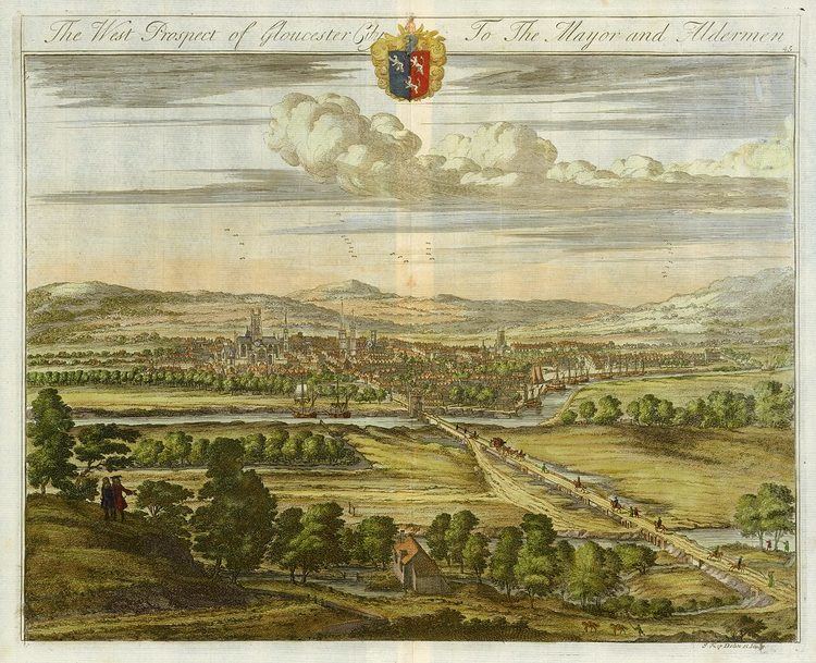
Map of South Gloucestershire
South Gloucestershire is a unitary authority area in South West England. It comprises multiple suburban areas to the north and east of Bristol. South Gloucestershire was created in 1996 from the northern section of the county of Avon, which was abolished at that time.
Contents
- Map of South Gloucestershire
- South gloucestershire show best bits
- South gloucestershire a great place
- History
- Demographic
- Economy
- Education
- Geography
- Transport
- Major Towns of South Gloucestershire and their population
- Other towns and villages
- Places of interest
- Democracy
- References
The area includes multiple towns and population centres, with many of these areas continuing to expand in both population and industry. Many of these towns and population areas are listed under two major subheadings below.
South Gloucestershire took its title for historic reasons, but as a unitary authority it is not administered as part of the shire county of Gloucestershire. It is, however, part of the ceremonial county of Gloucestershire, which means it shares its Lord Lieutenant (the Sovereign's representative to the county) with Gloucestershire. Because of its history as part of the county of Avon, South Gloucestershire works closely with the other unitary authorities that took over when that county was abolished, including shared services such as Avon Fire and Rescue Service and the Avon and Somerset Constabulary, together with co-operation in planning strategy for transport, roads and housing.
South gloucestershire show best bits
South gloucestershire a great place
History
Prior to the implementation of the Local Government Act 1972 on 1 April 1974, the area that now forms South Gloucestershire formed part of the shire county of Gloucestershire, comprising the urban districts of Kingswood and Mangotsfield and the Rural Districts of Warmley, Sodbury and Thornbury. However, under the terms of that act, the area was removed from Gloucestershire, and became part of the county of Avon, forming the districts of Kingswood and Northavon.
In 1996, the county of Avon was abolished, and South Gloucestershire was created as a unitary authority area comprising the former districts of Kingswood and Northavon. The area borders the city and county of Bristol, the Bath and North East Somerset unitary authority area, plus the shire county of Gloucestershire.
The geographic area currently known as South Gloucestershire should not be confused with Southern Gloucestershire. Nor should organisations or bodies in the past titled 'South Gloucestershire', (meaning Southern Gloucestershire), be confused with the area covered by the unitary authority.
Demographic
In the 2001 census, the population of South Gloucestershire was 245,641. In the 2011 census, this had increased to 262,767.
According to these estimates, 97.6 percent of the population was described as white, 0.8 percent as dual heritage, 0.7 percent as Asian or Asian British, 0.4 percent as Black or Black British and 0.5 percent as Chinese or other.
Much of the population is in towns that form the 'suburbs' to the north and east of Bristol. There are also the large Towns of Yate and Thornbury, along with Chipping Sodbury plus the population centres of Winterbourne, and Frampton Cotterell areas.
Economy
The main employers are the local authority with 9,500 people and the Ministry of Defence Headquarters for Defence Procurement and the Naval Support Command with 7,000 employees. Other key employers include Airbus, Rolls Royce and the Royal Mail, which dominates the Filton-Patchway area of South Gloucestershire. Friends Provident and Hewlett Packard also have major offices in nearby Stoke Gifford.
Many employers operate in the heavily developed area between the northern edge of Bristol and the M5 motorway, an area sometimes described as the North Fringe of Bristol. This includes the Cribbs Causeway shopping centre, comprising The Mall regional shopping centre and the surrounding retail parks. East of Patchway are the Aztec West and Almondsbury business parks either side of the A38, extending to Bradley Stoke and the M4/M5 Almondsbury Interchange. Employers with sites in this area include EE and the RAC.
Education
South Gloucestershire is home to 99 primary schools, 16 secondary schools, and post-16 colleges and centres. There is one university, the University of the West of England, which was a former polytechnic. In 2008, DCSF figures revealed that there was a 6.6% overall absence in the district's secondary schools, whilst 7.4% is the national average.
In 2005, the then Chancellor of the Exchequer recognised the City of Bristol's ties to science and technology by naming it one of six "science cities", and promising funding for further development of science in the city, with a £300 million science park planned at Emerson's Green, which is situated in South Gloucestershire.
Geography
The River Severn forms the north-western edge of the area, with a wide coastal plain terminated by an escarpment. East of this is the wide River Frome Valley drainage area. Further east is another escarpment running roughly north-south, passing between Yate and Chipping Sodbury and west of Pucklechurch. The Cotswolds Escarpment forms the eastern edge of South Gloucestershire.
A small part of the Cotswolds and the National Trust site of Dyrham Park are also in the district. South of the motorways are suburbs of Bristol while areas north are rural. Some of the inner green belts have been taken away by developments like the new town of Bradley Stoke.
Transport
South Gloucestershire is a major transport hub with many areas of South Gloucestershire having easy commuting access to: Bristol (A38 & M32 Roads), Bath to the east, as well as westward to South Wales and Cardiff via the two Severn bridges. Plus there is easy access to London, (M5 & M4 Motorway links), also Gloucester to the north. South Gloucestershire also has access to the major 'Avon' Ring Road. (See map for motorways).
This network of roads is of paramount importance to the industries and distribution centres in the area, as well as to the regional shopping centres - which give it a prime location.
Currently, South Gloucestershire is working with the City and County of Bristol in developing a large Metrobus system.
The area also has an important and very well used railway network, with many direct routes to towns and cities across the UK. This includes eastward to London and westward through the Severn Tunnel to Cardiff and the rest of South Wales. There are also routes down to the South-West counties and north to England's second city, Birmingham. Many routes cross in Stoke Gifford at the Bristol Parkway railway station.
South Gloucestershire is home to the eastern ends of the two Severn Bridges, which are the main arterial routes by road to and from South Wales.
Major Towns of South Gloucestershire, and their population
Other towns and villages
Places of interest
Democracy
Whilst the Liberal Democrats held an overall majority on the council 1999-2003, it has been no overall control for the rest of its existence. In 2012, it became one of the first authorities in the UK to return to a Committee System, abolishing the single party Cabinet, as allowed under the Localism Act
Under the Boundary Commission proposals, which took effect at the 2010 general election, the authority has been divided between three new constituencies, all lying within the authority boundary. These are:
County/Borough is a legal term denoting the type of constituency. County is a rural area, Borough is an urban area.