
Population 348 (2011) Sovereign state United Kingdom Local time Monday 9:00 AM | Post town Bristol | |
 | ||
Weather 8°C, Wind S at 10 km/h, 78% Humidity | ||
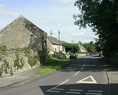
Tormarton is a village in South Gloucestershire, England. Its name may come from Thor Maer Tun meaning The settlement with the thorn (tree) on the boundary. Another source suggests the name derives from the church tower (Tor) on the border between Wessex and Mercia (Anglo-Saxon Meark). It is one mile North-East of junction 18 of the M4 motorway, with the A46 road and close to the border between Wiltshire and South Gloucestershire. In 2001 and 2011 there were 144 households and the population was 348. A National Trail, the Cotswold Way passes through the village. There is a church, a hotel, a pub and also a number of bed and breakfasts in the village. A Highways Agency depot with a salt dome is situated near to the village.
Contents
Map of Tormarton, Badminton, UK
History
It is thought that humans have been active in the area of Tormarton for more than 6000 years. In 1968 the bodies of three Bronze Age men were discovered near Tormarton, when a gas pipeline was being installed. Unusually two of the bodies showed combat wounds, they are now located in Bristol City Museum. Further excavations were made in 1999 and 2000, these found remains of two other bodies. They were estimated to be 3,500 years old. They are all thought to have all died at a similar time and were then buried in a ditch. A BBC documentary, Meet The Ancestors, was made that followed the second excavation. The area is thought to have been inhabited by the Romans as a stone coffin was found in nearby Hinton. The village was on the border of the Anglo Saxon kingdoms of Wessex and Mercia. The medieval village was larger than today, extensive eathworks to the north and east of the church suggest that this area may have been settled previously. Some historic buildings remain in Tormarton; St Mary Magdalene Church, Manor Farm and Tormarton Court. The Old Manor House was owned by the de la Riviere family but much of it was demolished in the English Civil War between 1642 and 1649, some sections survived and were incorporated into today's Manor Farm. Tormarton Court was constructed in the 18th century. The village became part of the Badminton estate owned by the Duke of Beaufort in 1789. In 1848 the population of the parish was 620.
Baron Altrincham, of Tormarton is a title in the Peerage of the United Kingdom that was created in 1945 for the politician Edward Grigg and then held by John Edward Poynder Grigg who disclaimed the title under the Peerage Act of 1963.
The M4 motorway to the West of Tormarton opened in 1967 with the section to the East running to Stanton St Quintin (Junction 17) opening four years later. There are plans to open a park and share facility at the motorway junction to allow commuters to park their cars and share lifts to and from Swindon, London, South Wales and Bath.
In 2008 SITA made a planning application to build a large in-vessel composting facility near Tormarton. Previously SITA had been proposing to site it on a brown field site in Pucklechurch but this was met with opposition from residents due to concerns it could pose a health risk and be an eyesore. The proposed facility would handle 30,000 tonnes of waste a year. BBC News reported that it was controversial with residents in Tormarton too.