
Length 464.7 km | ||
 | ||
South end: PH 9 PH 26 in Fangshan, Pingtung County | ||
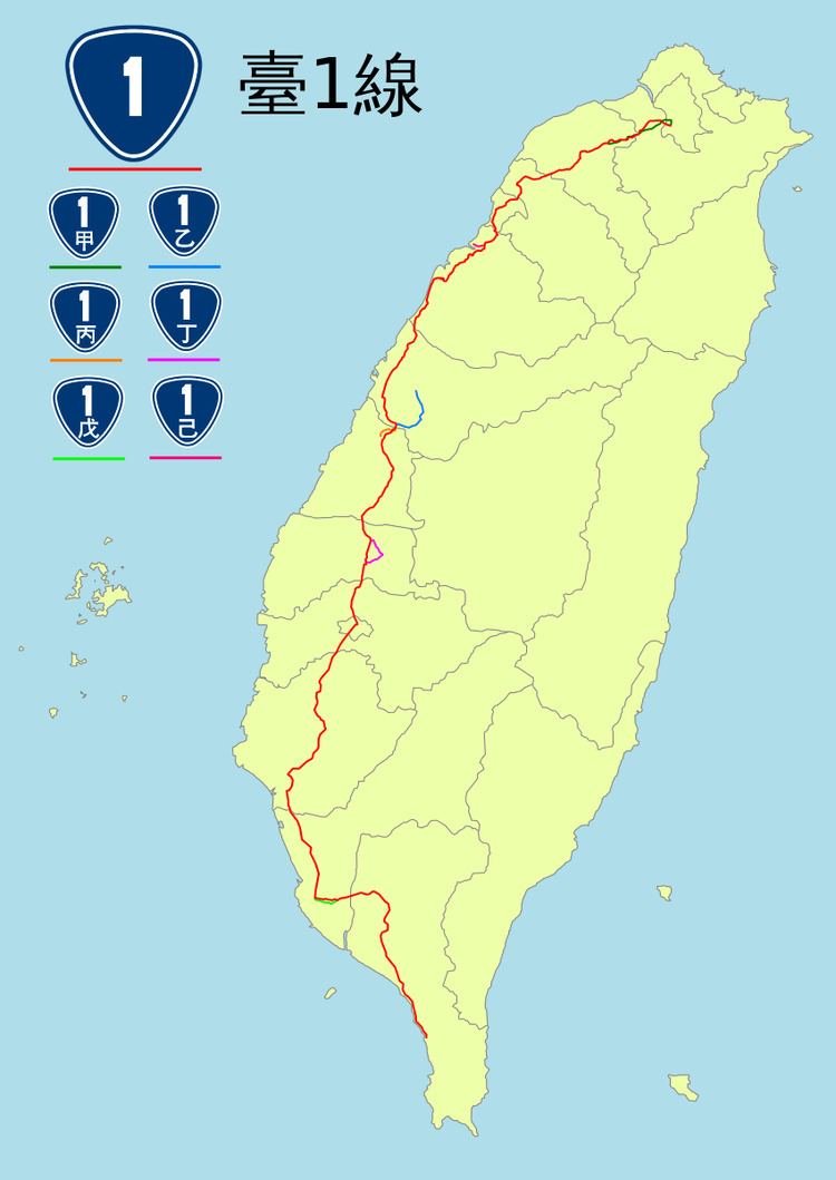
Provincial Highway 1 (Chinese: 台1線; pinyin: Tái yī xiàn) is a 464.693 km (288.747 mi)-long Taiwanese provincial highway that starts in the north of the country near Taipei Main Station and ends in the south at Fangshan, Pingtung County. It intersects with Provincial Highway 9 and Provincial Highway 26. Before the freeway system was built in Taiwan, this was the primary north-south highway for the island. The highway connects most of the major cities in Taiwan. In most parts of Taiwan, the road is known as The North-South Highway (縱貫公路).
Contents
- Map of Taiwan E58FB01E7B79A
- Taipei and New Taipei Cities
- Taoyuan Hsinchu Miaoli
- Taichung and Changhua
- Yunlin Chiayi and Tainan
- Kaohsiung and Pingtung
- Major cities along the route
- Special routes
- References
Map of Taiwan, %E5%8F%B01%E7%B7%9A
Kilometreposts on the highway count south from T'aipei.
Taipei and New Taipei Cities
Provincial Highway 1 begins in front of Executive Yuan in Taipei. The highway follows Zhongxiao West Road (忠孝西路) in Taipei, and crosses into Sanchong, New Taipei City via Zhongxiao Bridge (忠孝橋). The highway is known as Xinbei Blvd (新北大道) as it passes through Sanchong, Xinzhuang, and Taishan. PH 1 continues through Shulin and enters Taoyuan City.
Taoyuan, Hsinchu, Miaoli
In Taoyuan, PH1 passes through the most populated areas, including Guishan, Downtown Taoyuan, Bade, Zhongli, Pingzhen, and Yangmei. In downtown Taoyuan, PH1 runs concurrent with PH4. The highway continues to Hsinchu County, passing Hukou, Xinfeng, Zhubei before entering downtown Hsinchu City. PH 1 continues through Miaoli County, connecting the coastal townships of Zhunan, Toufen, Zaoqiao, Houlong, Xihu, Tongxiao, and Yuanli before entering Taichung City. The highway briefly runs concurrent with PH61 (Xibin Expressway, 西濱快速道路) in Tongxiao, Miaoli.
Taichung and Changhua
In Taichung City, PH 1 is an important route connecting the coastal districts. The highway passes through the districts of Dajia, Qingshui, Wuqi, Longjing, and Dadu, before exiting the city in Wuri. The highway continues to Changhua County, Passing through Changhua City and the agricultural townships of Huatan and Dacun before entering downtown Yuanlin. From Yuanlin the highway continues through a number of rural townships, including Puxin, Yongjing, Tianwei, Beidou, Xizhou, and Pitou. The highway enters Xiluo in Yunlin County via Xizhou Bridge (溪州大橋), passing through Zhuoshui River.
Yunlin, Chiayi, and Tainan
PH 1 in Yunlin county passes through Xiluo, Citong, Huwei, Dounan and Dapi before entering Chiayi County at Dalin. The highway continues through Xikou and Minxiong before entering Chiayi City. PH 1 then continues to Shuishang in Chiayi County before entering Tainan City. In Tainan City, the highway is one of the main roads that connect the major urban districts. The urban and rural districts served by PH 1 include Houbi, Xinying, Liuying, Liujia, Guantian, Shanhua, Xinshi, and Yongkang. The highway then goes through the downtown Tainan City and Tainan Airport as Zhonghua Rd. (中華路)
Kaohsiung and Pingtung
Entering Kaohsiung City, the highway passes through several rural and suburban districts, including Hunei, Luzhu, Gangshan, and Qiaotou, before entering central Kaohsiung City. In central Kaohsiung, PH 1 follows Minzu Rd. (民族路) before turning to an east-west direction along Jiuru Rd. (九如路) and Jianguo Rd. (建國路) in Fengshan. The highway crosses through Gaoping River in Daliao and continues toward Pingtung City in Pingtung County. After bypassing downtown Pingtung City, the highway goes back to a north-south direction, passing through Linluo, Neipu, Zhutian, Chaozhou, Nanzhou, Xinpi, Jiadong, Fangliao, and ends at the intersection of PH 9 and PH 26 in Fangshan.
Major cities along the route
Special routes
Special routes of Provincial Highway 1 use the same number, followed by a heavenly stem character. In English, these characters are replaced by letters in alphabetical order.