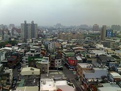
Population 218,290 (Jan 2016) Municipality Taoyuan, Taiwan | Area 47.75 km² Local time Monday 1:30 PM | |
 | ||
Weather 20°C, Wind W at 8 km/h, 87% Humidity Points of interest Xinshi Park, Yunnan Cultural Park, Sunflowers Art Gallery University Hsin Sheng College of Medical Care and Management | ||
Pingzhen District (Chinese: 平鎮區; pinyin: Píngzhèn Qū) is a district in the central part of Taoyuan City, Taiwan.
Contents
- Map of Pingzhen District Taoyuan City Taiwan 324
- History
- Geography
- Demographics
- Infrastructure
- Administrative divisions
- Transportation
- Tourist attractions
- Notable natives
- References
Map of Pingzhen District, Taoyuan City, Taiwan 324
History
Pingzhen was originally established as Changluliao during the Qing Dynasty rule of Taiwan. In 1920 under the Japanese rule, the city was renamed to Pingzhen. On 1 March 1992, it was upgraded as the third county-controlled city of Taoyuan County named Pingzhen City. On 25 December 2014, it was upgraded to a district named Pingzhen District when Taoyuan County was upgraded from a county to a municipality.
Geography
The district spans over 47.75 km² of area. It is located in the middle part of a hilly plateau and the entire district is on a slope.
Demographics
Pingzhen District has a population of 212,328 people as of December 2014. Most of the people in Pingzhen are Hakka people.
Infrastructure
To solve the water supply problem, many ponds have been built in the past. Currently the district has 123 ponds.
Administrative divisions
Pingzeng, Zengxing, Nanshi, Jinxing, Pingan, Pingnan, Shanfeng, Fulin, Yongguang, Zhuangjing, Yongfeng, Yongan, Songwu, Pingxing, Guangxing, Guangda, Guangren, Fudan, Fuxing, Yimin, Yixing, Shuanglian, Gaoshuang, Beishi, Beihua, Xinshi, Beian, Xinrong, Xinfu, Xinying, Xingui, Beixing, Jinling, Beigui, Beifu, Jianan, Huaan, Tungan, Xinan, Tungshi, Longen, Tungshe, Zhongzhen, Maoyi, Longxing and Zhongzheng Village.
