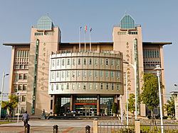
Divisions List15 villages Area 38.04 km² | Postal code 434 Population 76,696 (Jan 2016) | |
 | ||
Website www.longjing.taichung.gov.tw | ||
Longjing District (Chinese: 龍井區; pinyin: Lóngjǐng Qū) is a coastal suburban district in western Taichung, Taiwan.
Contents
- Map of Longjing District Taichung City Taiwan 434
- Geography
- Name and history
- Infrastructure
- Transportation
- References
Map of Longjing District, Taichung City, Taiwan 434
Geography
Longjing shares borders with Wuqi and Shalu to the north, Xitun to the east, the Pacific to the west, Dadu and Shengang in Changhua County to the south. The eastern part of Longjing is located on the Dadu Plateau.
Name and history
The area was originally occupied by the aboriginal Papora people. The term Longjing (龍井) means "Dragon Well"; a well is located in the area. Prior to Japanese rule, the district was called "Chie Tou Village" (茄投庄). During Japanese rule over Taiwan the district was renamed to Longjing (龍井), taken from the name of a famous well in the area named Dragon Eye Well (龍目井)
Dragon Eye Well is located in Longquan Village, under an old camphor tree. One of the Qing governors of Changhua recorded that the well's water was cool and refreshing, and the atmosphere was serene around the well. The name "Dragon Eye" comes from the two rocks around the well that makes it look like a dragon.
Infrastructure
Longjing houses Taichung Power Plant, the world's largest coal-fired power plant.
Transportation
The district is served by a variety of national roads.
The district can be reached by rail through TRA Longjing Station.
