
Length 552.4 km | PA PA 179 → | |
 | ||
Bigrigtravels live erie to portersville pennsylvania interstate 79 december 12 2016
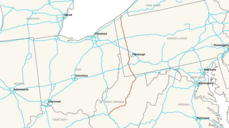
Interstate 79 (abbreviated I-79) is an Interstate Highway in the eastern United States, designated from Interstate 77 in Charleston, West Virginia to Pennsylvania Route 5 and Pennsylvania Route 290 in Erie, Pennsylvania. It is a primary thoroughfare through western Pennsylvania and West Virginia, and makes up part of an important corridor to Buffalo, New York, and the border with Canada.
Contents
- Bigrigtravels live erie to portersville pennsylvania interstate 79 december 12 2016
- Map of I 79 United States
- Route description
- West Virginia
- Pennsylvania
- History
- Auxiliary routes
- References
Map of I-79, United States
In West Virginia, Interstate 79 is known as the Jennings Randolph Expressway. In the three most northern counties it is signed as part of the High Tech Corridor. For most of its Pennsylvania stretch, it is known as the Raymond P. Shafer Highway.
Route description
Except at its northern end, I-79 is located on the Allegheny Plateau. Despite the somewhat rugged terrain, the road is relatively flat. Most of the highway is at an elevation of about 1000 to 1200 feet (300 to 360 m) above sea level, with some lower areas near both ends and higher areas near Sutton, West Virginia. In the hillier areas, this flatness is achieved by curving around hills, along ridges, and in or partway up river valleys. From Sutton, West Virginia north, Interstate 79 generally parallels the path of U.S. Route 19.
West Virginia
I-79 begins at a three-way directional Y interchange with Interstate 77 along the northwest bank of the Elk River just northeast of Charleston. For its first 67 miles (108 km), to a point just south of Flatwoods, I-79 is located in the watershed of the Elk River, which drains into the Kanawha River. It crosses the Elk River twice — at Frametown and Sutton - and never strays more than about 15 to 20 miles (25 to 30 km) from it.
Pennsylvania
I-79 enters Pennsylvania after leaving West Virginia University in Morgantown, WV. South of Washington, PA, I-79 traverses the mostly rural Greene County area.
Between mile markers 34 and 38, I-79 is multiplexed with I-70 in the Washington, PA area before heading north towards Pittsburgh.
The freeway into Pittsburgh requires drivers to use I-376 while I-79 completely bypasses the city. Beyond the Pittsburgh area, I-79 traverses more rural areas in Butler, Lawrence, Mercer, Crawford, and Erie counties before arriving at its termination point in Erie.
Around the 100 mile marker on the northbound side are two ghost ramps that were specifically built for the Boy Scouts of America in order to have access to Moraine State Park without having to get on U.S. Route 422 for the 1973 and 1977 National Scout Jamborees, which were held at Moraine. The ramps were permanently closed after the 1977 event, but remain in place as of 2013.
I-79 was completely re-built in the Pittsburgh area in the early 1990s.
History
The Pennsylvania General Assembly authorized the Pennsylvania Turnpike Commission to build two extensions in the 1950s. The Northwestern Extension, authorized in 1953, was to stretch from the main Pennsylvania Turnpike north to Erie, and would have included a lateral connection between Ohio and New York (later built as Interstate 90). The Southwestern Extension, authorized in 1955, was to run south from the main line near Pittsburgh to West Virginia, connecting there with an extension of the West Virginia Turnpike. Except for the section between Washington and the Pittsburgh area, which was included as part of Interstate 70, the first portion of I-79 to be added to the plans was north from Pittsburgh to Erie, along the U.S. Route 19 corridor.
In September 1955, two short urban portions were designated:
The number 79 was assigned in 1958, and an extension south along I-70 to Washington and beyond to Charleston was approved on October 18, 1961. This extension also paralleled US 19 to near Sutton, where it turned westerly to reach Charleston. (The part of US 19 from Sutton south to Interstate 77 at Beckley, WV has since been four-laned as Corridor L of the Appalachian Development Highway System.)
On December 21, 1967, the first section of I-79 in West Virginia, between Exits 125 (Saltwell Road) and 132 (South Fairmont), opened to traffic. This five-mile (8 km) section bypassed part of WV 73 between Bridgeport and Fairmont. Another five miles (8 km) opened in July 1968, extending the highway on a bypass of downtown Fairmont to Exit 137 (East Park Avenue). It was further extended 9.5 miles (15 km) towards Morgantown on October 15, 1970, bypassing more of WV 73 to Exit 146 (Goshen Road) south of that city.
On June 29, 1970 the swap of I-79 and I-279 was approved. At the same time, I-76 was extended west from downtown Pittsburgh over former I-79 to the new location of I-79 west of Pittsburgh, so I-279 only ran north from downtown Pittsburgh. On December 3, 1971, I-76 was rerouted to bypass Pittsburgh, and I-279 was extended to I-79 utilizing the former section of I-76.
On June 29, 1973, I-79 was extended from West Virginia Exit 146 to Exit 148 (I-68), where at one point, traffic was forced onto the newly opened west end of Corridor E (now I-68) to Exit 1. A further extension of six miles (10 km), including the Uffington Bridge over the Monongahela River southwest of Morgantown, was opened on August 30, 1973, leading north to Exit 155 (Star City). This completed I-79 from north of Bridgeport to north of Morgantown.
To the south of Bridgeport, the first two sections were both opened on December 22, 1971. One of these ran ten miles (16 km) from Exit 51 (Frametown) to Exit 62 (Sutton), and the other from Exit 105 (Jane Lew) to Exit 115 (Nutter Fort). On September 19, 1973, another 7.5-mile (12.1 km) stretch was opened, from Exit 105 (Jane Lew) south to Exit 99 (Weston).
In 1973, significant portions of the interstate were completed. Interstate 79 opened from Exit 62 to Exit 99. Another 23.9 miles (38.5 km), from Exit 67 (Flatwoods) north to Exit 91 (Roanoke), opened on November 28, 1973, along with the section from exit 115 north to exit 117 (Anmoore), completing the route between Frametown and Morgantown except in the Bridgeport area.
A 5.5-mile (8.9 km) extension from exit 51 south to exit 46 (Servia) opened on February 1, 1974, and County Route 11 to WV 4 near Duck was widened to handle the increased load. On the same day, two lanes opened from exit 155 (Osage) north to the state line.
On October 16, 1974, two pieces of I-79 were opened: the other two lanes of the 6.6 miles (10.6 km) from exit 155 to the state line, and 7.1 miles (11.4 km) between exits 117 (Anmoore) and 125 (north of Bridgeport). On the same day, the eastern end of Corridor D and the western end of Corridor E, both connecting to I-79 (at exits 119 and 148), were opened. This completed I-79 in West Virginia north of exit 46 (Servia); it was extended south to exit 25 (Amma) in late November and to U.S. Route 119 north of Clendenin (exit 19) on November 13, 1975. It was opened from exit 19 to exit 9 (Elkview) on November 18, 1977, and finally completed to Interstate 77 in 1979.
On July 25, 1975, Interstate 79 was opened between exits 1 and 14 in Pennsylvania. The last piece of I-79 between West Virginia and Erie — the Neville Island Bridge over the Ohio River - opened on September 3, 1976.
In late 2008, the "missing ramps" of the I-79/I-376 interchange (PA 60 was designated as the route for southbound traffic seeking to go to Pittsburgh International Airport & airport traffic seeking to go northbound on I-79) were completed.
In June 2009, I-376 was extended west and north of downtown Pittsburgh, and I-279 was truncated back to the section only running from downtown Pittsburgh north to I-79.