
Founded March 12, 1800 Area 2,059 km² | Congressional district 3rd Website www.co.butler.pa.us Population 185,476 (2013) Unemployment rate 4.0% (Apr 2015) | |
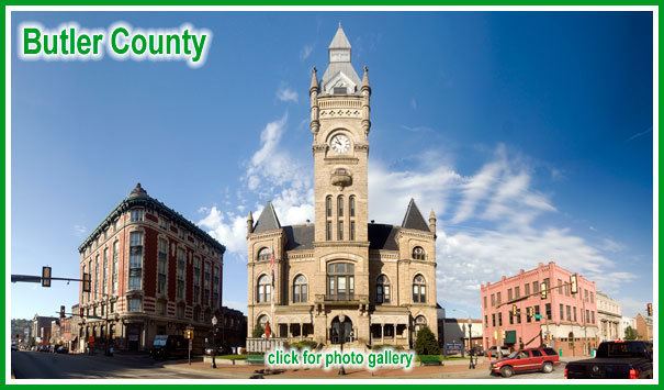 | ||
Points of interest Harmony Historic District, Jennings Environmental Educatio, Moraine State Park, North Boundary Park, Succop Nature Park Destinations | ||
Golf courses of butler county pennsylvania
Butler County is a county located in the U.S. state of Pennsylvania. As of the 2010 census, the population was 183,862. Its county seat is Butler. Butler County was created on March 12, 1800, from part of Allegheny County and named in honor of General Richard Butler, a hero of the American Revolution.
Contents
- Golf courses of butler county pennsylvania
- Map of Butler County PA USA
- History
- Geography
- Waterways
- Demographics
- County judges
- District judges
- State Senate
- State House of Representatives
- United States House of Representatives
- United States Senate
- Politics
- Colleges and universities
- Technical schools
- Public school districts
- Media
- Parks
- Trails
- Airports
- Transit
- Communities
- City
- Census designated places
- Unincorporated communities
- Population ranking
- In popular culture
- References
Map of Butler County, PA, USA
Butler County is included in the Pittsburgh, PA Metropolitan Statistical Area.
History
Some famous inventions and discoveries were made in Butler County. It was in Saxonburg, that the designer of the Brooklyn Bridge, John Roebling, invented his revolutionary "wire rope." At what is now known as Oil Creek, Butler County resident William Smith and Edwin Drake first proved that oil could be tapped from underground for consistent supply. The Jeep was developed in Butler County by American Bantam in 1941.
Famous politicians have lived in and traveled through Butler County. George Washington passed through during the French and Indian War. Butler's only U.S. Senator, Walter Lowrie, built a home in 1828 that still stands behind the Butler County Courthouse. The Butler County Historical Society's office is located in this home. Butler's highest ranked federal official ever is William J. Perry, Secretary of Defense under President Bill Clinton from 1994-1997. He graduated from Butler High School in 1945. In 1923, President Warren G. Harding's funeral train passed through Butler County on its way back to Washington D.C. John F. Kennedy delivered a speech in front of the Butler County Courthouse during the United States presidential election, 1960. Hubert Humphrey also spoke in Butler during this time period. Then in 2004, Vice President Dick Cheney delivered a speech in Saxonburg to rally support for President George W. Bush during the United States presidential election, 2004. Bret Michaels, lead singer of the rock band Poison was also born here in 1963.
Geography
According to the U.S. Census Bureau, the county has a total area of 795 square miles (2,060 km2), of which 789 square miles (2,040 km2) is land and 6.1 square miles (16 km2) (0.8%) is water.
It is the location of Moraine State Park, with the 3,000-acre (12 km2) glacial lake, Lake Arthur. Lake Arthur is used for fishing and sailing, and the surrounding park is used for hiking and hunting.
Waterways
Demographics
As of the census of 2000, there were 174,083 people, 65,862 households, and 46,827 families residing in the county. The population density was 221 people per square mile (85/km²). There were 69,868 housing units at an average density of 89 per square mile (34/km²). The racial/ethnic makeup of the county is 96.5% White, 0.9% Black or African American, 0.09% Native American, 0.8% Asian, 0.03% Pacific Islander, 0.17% from other races, 0.7% from two or more races; and 0.9% Hispanic or Latino of any race. 35% were of German, 12% Irish, 11% Italian, 7% English, 6% American 5% Polish, and 4% Scotch-Irish ancestry according to Census 2000.
There were 65,862 households out of which 32.90% had children under the age of 18 living with them, 59.80% were married couples living together, 8.10% had a female householder with no husband present, and 28.90% were non-families. 24.20% of all households were made up of individuals and 10.40% had someone living alone who was 65 years of age or older. The average household size was 2.55 and the average family size was 3.04.
In the county, the population was spread out with 24.60% under the age of 18, 8.80% from 18 to 24, 29.40% from 25 to 44, 23.00% from 45 to 64, and 14.30% who were 65 years of age or older. The median age was 38 years. For every 100 females there were 95.40 males. For every 100 females age 18 and over, there were 91.80 males.
County judges
District judges
State Senate
State House of Representatives
United States House of Representatives
United States Senate
Politics
Unlike the rest of traditionally Democratic Western Pennsylvania, Butler County has leaned towards the Republican Party. The last Democratic presidential candidate to win Butler was Lyndon Johnson in 1964. In the 2000 U.S. presidential election, the county was carried by Republican George W. Bush 62% to Democrat Al Gore 35%. In the 2004 U.S. presidential election, the county was carried by Republican George W. Bush 64% to Democrat John Kerry 35%. In the 2008 U.S. presidential election, the county was carried by Republican John McCain 63% to Democrat Barack Obama 35%. Additionally, John McCain carried every Western Pennsylvania county except for Allegheny County and Erie County, in sharp contrast to previous years, like 2004, in which Democratic candidate John Kerry carried 5 counties in Western Pennsylvania. As of May 2007, there are 121,719 registered voters in Butler County.
Colleges and universities
Technical schools
Public school districts
In 2008, Pennsylvania School Districts were ranked by the Pittsburgh Business Times. The ranking was based on student academic performance as demonstrated in 3 years of PSSA results.
Media
Parks
There are 2 Pennsylvania state parks in Butler County.
Before the glacier dam. Slippery Rock and Muddy creeks flowed north while extinct McConnells Run flowed south. The glacier dammed Lake Prouty on the edge of the drainage divide. Eventually Lake Pouty spilled over and rushed to the south, carving Slippery Rock Creek Gorge. Lakes Watts and Edmund drained into the gorge, digging it deeper and making Slippery Rock and Muddy creeks flow south. Areas of the 400-foot (120 m) deep Slippery Rock Gorge may be seen at nearby McConnells Mill State Park.
The glacier created a landscape of rolling hills topped with hardwood trees and swamps in the valley bottoms. Moraines containing gravel, sand and clay were draped upon the landscape and silt was left on the extinct lake bottoms. Reference to: http://www.dcnr.state.pa.us/stateParks/parks/moraine/moraine_history.aspx
Trails
Airports
Transit
Communities
Under Pennsylvania law, there are four types of incorporated municipalities: cities, boroughs, townships, and, in at most two cases, towns. The following cities, boroughs and townships are located in Butler County:
City
Census-designated places
Census-designated places are geographical areas designated by the U.S. Census Bureau for the purposes of compiling demographic data. They are not actual jurisdictions under Pennsylvania law. Other unincorporated communities, such as villages, may be listed here as well.
Unincorporated communities
Several of these communities, most notably Renfrew, Lyndora, Herman, Sarver, Cabot, Boyers, and Forestville, have post offices and zip codes, but aren't officially incorporated under Pennsylvania law, and exist entirely within townships.
Population ranking
The population ranking of the following table is based on the 2010 census of Butler County.
† county seat
In popular culture
Butler County has often been used as a setting for films shot in the North Pittsburgh area. Such films include:
Films set in Butler County, but not necessarily filmed there.
Novels set in Butler County.
Benjamin's Field, a trilogy by local author J. J. Knights