
Country United States County Lewis Area code(s) 304 Zip code 26452 Local time Saturday 8:49 AM | State West Virginia Time zone Eastern (EST) (UTC-5) Elevation 311 m Population 4,104 (2013) | |
 | ||
Incorporated 1818 (town)1913 (city) Weather 7°C, Wind NW at 8 km/h, 91% Humidity | ||
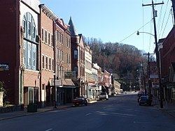
Weston is a city in Lewis County, West Virginia, United States. The population was 4,110 at the 2010 census. It is the county seat of Lewis County, and home to the West Virginia Museum of American Glass and the Trans-Allegheny Lunatic Asylum.
Contents
Map of Weston, WV 26452, USA
History
Weston was founded in 1818 as Preston; the name was changed to Fleshersville soon after, and then to Weston in 1819. The city was incorporated in 1913.
Weston is the site of the former Trans-Allegheny Lunatic Asylum[1], a psychiatric hospital and National Historic Landmark which has been mostly vacant since its closure in 1994 upon its replacement by the nearby William R. Sharpe Jr. Hospital. Jackson's Mill, a childhood home of Stonewall Jackson, is approximately four miles (6 km) north of Weston; it has been operated as a 4-H facility since the 1920s and is also the site of conference center operated by the West Virginia University Extension Service. It is listed on the National Register of Historic Places as the Jackson's Mill State 4-H Camp Historic District.
Weston has two national historic districts: the Weston Downtown Historic District and Weston Downtown Residential Historic District. Other buildings on the National Register of Historic Places are the Jonathan M. Bennett House and the former Weston Colored School.
Geography
Weston is located at 39°2′31″N 80°28′12″W (39.041857, -80.469929), along the West Fork River at its confluence with Stonecoal Creek in central Lewis County.
According to the United States Census Bureau, the city has a total area of 2.00 square miles (5.18 km2), of which, 1.95 square miles (5.05 km2) is land and 0.05 square miles (0.13 km2) is water.
The city is crossed by Interstate 79, U.S. Route 19, U.S. Route 33 and U.S. Route 119.
Climate
The climate in this area is characterized by hot, humid summers and generally mild to cool winters. According to the Köppen Climate Classification system, Weston has a humid subtropical climate, abbreviated "Cfa" on climate maps.
2010 census
As of the census of 2010, there were 4,110 people, 1,811 households, and 1,082 families residing in the city. The population density was 2,107.7 inhabitants per square mile (813.8/km2). There were 2,135 housing units at an average density of 1,094.9 per square mile (422.7/km2). The racial makeup of the city was 97.0% White, 0.8% African American, 0.7% Asian, and 1.5% from two or more races. Hispanic or Latino of any race were 1.3% of the population.
There were 1,811 households of which 27.7% had children under the age of 18 living with them, 40.9% were married couples living together, 13.3% had a female householder with no husband present, 5.5% had a male householder with no wife present, and 40.3% were non-families. 33.7% of all households were made up of individuals and 16.6% had someone living alone who was 65 years of age or older. The average household size was 2.27 and the average family size was 2.86.
The median age in the city was 41.4 years. 22% of residents were under the age of 18; 7.7% were between the ages of 18 and 24; 26.1% were from 25 to 44; 26.2% were from 45 to 64; and 18.1% were 65 years of age or older. The gender makeup of the city was 48.7% male and 51.3% female.
2000 census
As of the census of 2000, there were 4,317 people, 1,942 households, and 1,172 families residing in the city. The population density was 2,533.5 inhabitants per square mile (980.5/km²). There were 2,222 housing units at an average density of 1,304.0 per square mile (504.7/km²). The racial makeup of the city was 98.24% White, 0.19% African American, 0.09% Native American, 0.72% Asian, 0.19% from other races, and 0.58% from two or more races. Hispanic or Latino of any race were 0.46% of the population.
There were 1,942 households out of which 24.5% had children under the age of 18 living with them, 44.4% were married couples living together, 13.2% had a female householder with no husband present, and 39.6% were non-families. 34.7% of all households were made up of individuals and 18.6% had someone living alone who was 65 years of age or older. The average household size was 2.22 and the average family size was 2.84.
In the city, the population was spread out with 20.3% under the age of 18, 7.9% from 18 to 24, 27.1% from 25 to 44, 24.9% from 45 to 64, and 19.7% who were 65 years of age or older. The median age was 42 years. For every 100 females there were 83.2 males. For every 100 females age 18 and over, there were 80.4 males.
The median income for a household in the city was $26,690, and the median income for a family was $33,783. Males had a median income of $27,988 versus $17,335 for females. The per capita income for the city was $14,089. About 15.1% of families and 18.8% of the population were below the poverty line, including 25.8% of those under age 18 and 9.3% of those age 65 or over.