
Founded November 7, 1803 Congressional district 3rd Area 1,769 km² Unemployment rate 4.8% (Apr 2015) | Population 115,195 (2013) | |
 | ||
Website www.mcc.co.mercer.pa.us Points of interest Wendell August Forge, Shenango River Lake, Deer Park, Grove City Memorial Park, Buhl Farm Park Colleges and Universities Grove City College, Thiel College, Penn State Shenango, Laurel Technical Institute, Mercer County Career C | ||
Mercer County is a county located in the U.S. state of Pennsylvania. As of the 2010 census, the population was 116,638. Its county seat is Mercer, and its largest city is Hermitage. The county was created in 1800 and later organized in 1803.
Contents
- Map of Mercer County PA USA
- Geography
- Adjacent counties
- Demographics
- Government and politics
- Political bellwether
- County Commissioners
- Higher education
- Career based education
- Public school districts
- Charter schools
- Recreation
- Communities
- Cities
- Census designated places
- Unincorporated communities
- Former community
- Population ranking
- References
Map of Mercer County, PA, USA
Mercer County is included in the Youngstown-Warren-Boardman, OH-PA Metropolitan Statistical Area.
Geography
According to the U.S. Census Bureau, the county has a total area of 683 square miles (1,770 km2), of which 673 square miles (1,740 km2) is land and 10 square miles (26 km2) (1.5%) is water.
Adjacent counties
Demographics
As of the census of 2000, there were 120,293 people, 46,712 households, and 32,371 families residing in the county. The population density was 179 people per square mile (69/km²). There were 49,859 housing units at an average density of 74 per square mile (29/km²). The racial makeup of the county was 93.13% White, 5.25% Black or African American, 0.11% Native American, 0.40% Asian, 0.02% Pacific Islander, 0.17% from other races, and 0.91% from two or more races. 0.67% of the population were Hispanic or Latino of any race. 24.5% were of German, 12.0% Italian, 10.5% Irish, 9.3% English and 6.8% American ancestry according to Census 2000.
There were 46,712 households out of which 29.30% had children under the age of 18 living with them, 54.80% were married couples living together, 10.90% had a female householder with no husband present, and 30.70% were non-families. 27.00% of all households were made up of individuals and 13.20% had someone living alone who was 65 years of age or older. The average household size was 2.44 and the average family size was 2.96.
In the county, the population was spread out with 23.40% under the age of 18, 8.90% from 18 to 24, 26.10% from 25 to 44, 23.50% from 45 to 64, and 18.10% who were 65 years of age or older. The median age was 40 years. For every 100 females there were 94.70 males. For every 100 females age 18 and over, there were 90.80 males.
Government and politics
As of November 2008, there are 80,917 registered voters in Mercer County.
Political bellwether
Mercer County was previously considered a political bellwether for the state of Pennsylvania since its demographics, urban/rural ratio, and party affiliation once closely mirrored the state as a whole. In 2000, Al Gore carried it against George W. Bush. This trend failed to hold true during 2004 Presidential election and 2008 Presidential election, in which Mercer County voted more conservatively than the rest of the state. In 2004, George W. Bush won Mercer County with 51% of the vote. That year John Kerry won the state as a whole with 51% of the popular vote. In 2008, John McCain won Mercer County by fewer than 200 votes, as he and Barack Obama each received roughly 49% of the popular vote. Barack Obama won the state of Pennsylvania as a whole with 55% of the popular vote. Each of the three statewide office winners also carried Mercer in 2008. In 2016, Donald Trump won Mercer County by 12,403 votes. Trump won the state of Pennsylvania. Each of the three statewide office republican candidates each carried Mercer in 2016.
County Commissioners
Secretary
Higher education
Career-based education
Public school districts
Charter schools
Recreation
There is one Pennsylvania state park in Mercer County. Maurice K. Goddard State Park, named for Maurice K. Goddard, former Secretary of the Pennsylvania Department of Environmental Resources, is just off exit 130 of Interstate 79 on Pennsylvania Route 358 near Stoneboro.
The Wendell August Forge, the last remaining working forge in the state, was open to the public for tours, but it burned down on March 6, 2010. It has since reopened in new facilities.
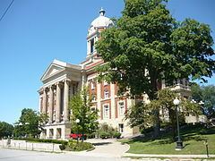
Mercer County Court House built in 1909.
Communities
Under Pennsylvania law, there are four types of incorporated municipalities: cities, boroughs, townships, and, in one case, towns. The following cities, boroughs and townships are located in Mercer County:
Cities
Census-designated places
Unincorporated communities
Former community
Population ranking
The population ranking of the following table is based on the 2010 census of Mercer County.
† county seat