
Type Highway Length 2,964 km | Opened 1955 Constructed 1955 | |
 | ||
Route number(s) National Route 1 (NT border to Cairns) A1 (Cairns to Cooroy) M1 (Cooroy to NSW border) Southeast end QLD/NSW border near Coolangatta | ||
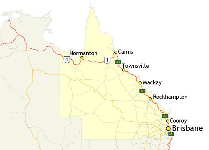
In Queensland, Highway 1 is a 2,964-kilometre (1,842 mi) long route that crosses the state, from the Northern Territory (NT) border near Wollogorang to Cairns, and then travels along the coastline to the New South Wales (NSW) border near Coolangatta. Highway 1 continues around the rest of Australia, joining all mainland state capitals, and connecting major centres in Tasmania. All roads within the Highway 1 system are allocated a road route numbered 1, M1, A1, or B1, depending on the state route numbering system. In Queensland, the highway is designated as National Route 1 from the NT border to Cairns, Route A1 from Cairns to Cooroy, and then Route M1 down to the NSW border.
Contents
History
Highway 1 was created as part of the National Route Numbering system, adopted in 1955. The route was compiled from an existing network of state and local roads and tracks.
Route description
The Savannah Way is the largely unsignposted route for Highway 1 between the Northern Territory border and Normanton. From there, it follows the Gulf Developmental Road, Kennedy Highway and Captain Cook Highway to Cairns. Highway 1 then travels southwards along the Queensland Coast along Bruce Highway to Brisbane. The highway travels through Brisbane as the Gateway Motorway, and continues south as the Pacific Motorway, towards the Gold Coast, and subsequently, the New South Wales border.
The following sections, which are freeways or dual carriageways, are designated as route M1: