
Type Highway Formerroute number National Route 78 | Route number(s) A6 Length 754 km | |
 | ||
Major settlements | ||
Road train on flinders highway queensland australia
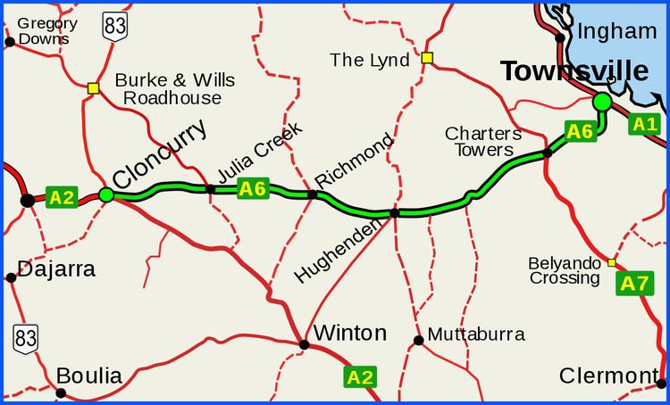
The Flinders Highway is a highway that crosses Queensland east to west, from Townsville on the Pacific coast to Cloncurry. The road continues as the Barkly Highway from Cloncurry to the Northern Territory border at Camooweal and beyond. The Flinders Highway passes a number of small outback towns and typical outback landscape predominates towards the inland. It was known as National Route 78 before Queensland began to convert to the alphanumeric system being adopted in Australia and is now designated as A6. The highway is also known as Overlander's Way. Its entire length is part of the National Land Transport Network (formerly Auslink).
Contents
- Road train on flinders highway queensland australia
- Map of Flinders Hwy Queensland Australia
- Charters Towers
- Hughenden
- Richmond
- Julia Creek
- Cloncurry
- References
Map of Flinders Hwy, Queensland, Australia
Charters Towers
Charters Towers, 133 km to the south west from Townsville. A former gold rush town with a population of 30 000 in 1890. At that time it was known as "The World" because it seemed to be the centre of everything. Presently it is a centre for cattle grazing, with gold mining continuing to be an important industry. Much of the elegant gold rush architecture of the nineteenth remains in place and is a tourist attraction.
Hughenden
Located 243 km further on, Hughenden, the administrative centre of Flinders shire is in the heart of sheep and cattle country.
Richmond
Richmond, a former gold rush town located 112 km further west. Currently a pastoral centre.
Julia Creek
Julia Creek, 147 km further west, another pastoral settlement
Cloncurry
Cloncurry, former copper-mining town located 139 km west from Julia Creek. The first regular Qantas flights started between here and Charleville in 1922 and Royal Flying Doctor Service of Australia service started here in 1928. Nowadays it is an important road and rail junction. Flinders Highway ends here.